MyTopo
Uxbridge Massachusetts US Topo Map
Couldn't load pickup availability
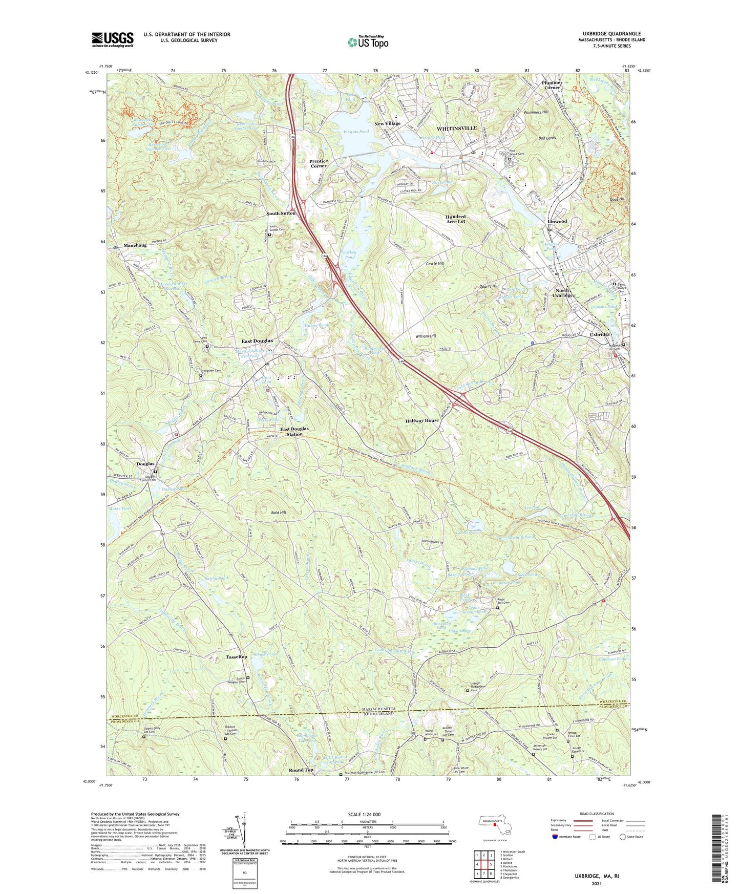
2021 topographic map quadrangle Uxbridge in the states of Massachusetts, Rhode Island. Scale: 1:24000. Based on the newly updated USGS 7.5' US Topo map series, this map is in the following counties: Worcester, Providence. The map contains contour data, water features, and other items you are used to seeing on USGS maps, but also has updated roads and other features. This is the next generation of topographic maps. Printed on high-quality waterproof paper with UV fade-resistant inks.
Quads adjacent to this one:
West: Oxford
Northwest: Worcester South
North: Grafton
Northeast: Milford
East: Blackstone
Southeast: Georgiaville
South: Chepachet
Southwest: Thompson
Contains the following named places: Aldrich - Thayer Lot Cemetery, Aldrich Pond, Aldrich School, Amasa Esten Lot, Arcade Pond, Armenian Apostolic Church, Bad Lands, Bald Hill, Bating Brook, Bating Pond, Bazeley Pond, Big Round Top Pond, Bitt Shop Pond, Black Hut State Management Area, Black Pond, Blissful Meadows Golf Course, Caprons Pond, Caprons Pond Dam, Castle Hill, Caswell Brook, Cedar Swamp, Cedar Swamp Brook, Cedar Swamp Pond, Centerville Brook, Chase Pond, Chockalog Pond, Cold Spring Brook, Cook Allen Brook, Cooke - Thayer Lot, Douglas, Douglas Center Cemetery, Douglas Center School, Douglas Early Childhood Learning Center, Douglas Fire Department, Douglas Memorial High School, Douglas Orchard, Douglas Police Department, Douglas Post Office, Dudley Brook, Dudley Pond, Dudley Pond Dam, Dunleavey Brook, Dunleavey Pond, Earl D Taft School, East Douglas, East Douglas Census Designated Place, East Douglas Elementary School, East Douglas High School, East Douglas Station, East Douglas United Methodist Church, Ellis Pond, Evergreen Cemetery, Fairlawn Christian Church, Farrel Brook, First Congregational Church, Fish Pond, Gilboa Brook, Gilboa Pond, Gilboa Pond Dam, Goat Hill, Greene Brook, Halfway House, Happy Hollow Brook, Hayward Mill, Hemlock Brook, Houghton Pond, Hundred Acre Lot, Hunt Pond, Jeremiah Mowry Lot, Joels Pond, Joseph Esten Lot, Joseph Richardson Cemetery, Lackey Dam, Lackey Pond, Laurel Brook, Lee Pond, Lee Pond Dam, Lee Reservoir, Lee Reservoir Dam, Linwood, Linwood Historic District, Linwood Pond, Linwood Pond Dam, Linwood Post Office, Lippitt Eddy Lot Cemetery, Little Round Top Pond, Manchaug, Manchaug Post Office, Meadow Pond, Meadow Pond Dam, Morse Pond, Mumford River Reservoir, New Village, North Uxbridge, North Uxbridge Baptist Church, North Uxbridge Post Office, Northbridge Fire Department, Northbridge High School, Northbridge Middle School, Northbridge Primary School, Old Mill Pond Dam, Peabody Pond, Pine Grove Cemetery, Pleasant Street Christian Reformed Church, Plummer Corner, Plummers Hill, Potter Road Dam, Prentice Corner, Prospect Hill Cemetery, Purgatory Brook, Quarry Hill, Reservoir Number Five, Reservoir Number Five Dam, Reservoir Number Four, Reservoir Number Four Dam, Reservoir Number Six, Reservoir Number Six Dam, Riddle Brook, Riley Pond, Rivulet Mill Complex, Rivulet Pond, Rivulet Pond Dam, Robbins - Lapham Lot Cemetery, Rogersons Village Historic District, Round Top Fishing Area, Royal Taft Cemetery, Saint Annes Church, Saint Camillus Hospital, Saint Denis Cemetery, Saint Mary's Cemetery, Sawmill Pond, Scadden Brook, Sherman - Burlingame Lot Cemetery, South Douglas Cemetery, South Sutton, South Sutton Cemetery, Steamburg Brook, Sutton Falls Dam, Sutton Falls Reservoir, Swans Pond, Swans Pond Dam, Taft Memorial Methodist Church, Taft Memorial Park, Tasseltop, Tinkerville Brook, Town of Uxbridge, Towne Plaza Shopping Center, Trinity Episcopal Church, Upper Tucker Pond Dam, Uxbridge, Uxbridge Common District, Uxbridge Fire Department Station 1 Headquarters, Uxbridge Fire Department Station 2, Uxbridge Fire Department Station 3, Uxbridge Free Public Library, Uxbridge High School, Uxbridge Shopping Center, Uxbridge Town Hall, Uxbridge Town Police Department, Village Congregational Church, W Edward Balmer School, Webster Intermediate School, Weeks Pond, Wellman Brook, Whitin Pond, Whitin Pond Dam, Whitins Pond, Whitinsville, Whitinsville Census Designated Place, Whitinsville Christian School, Whitinsville Historic District, Whitinsville Post Office, Whitinsville United Methodist Church, Whittin Intermediate School, William Hill, Young - White Lot, ZIP Codes: 01525, 01569, 01588