MyTopo
Georgiaville Rhode Island US Topo Map
Couldn't load pickup availability
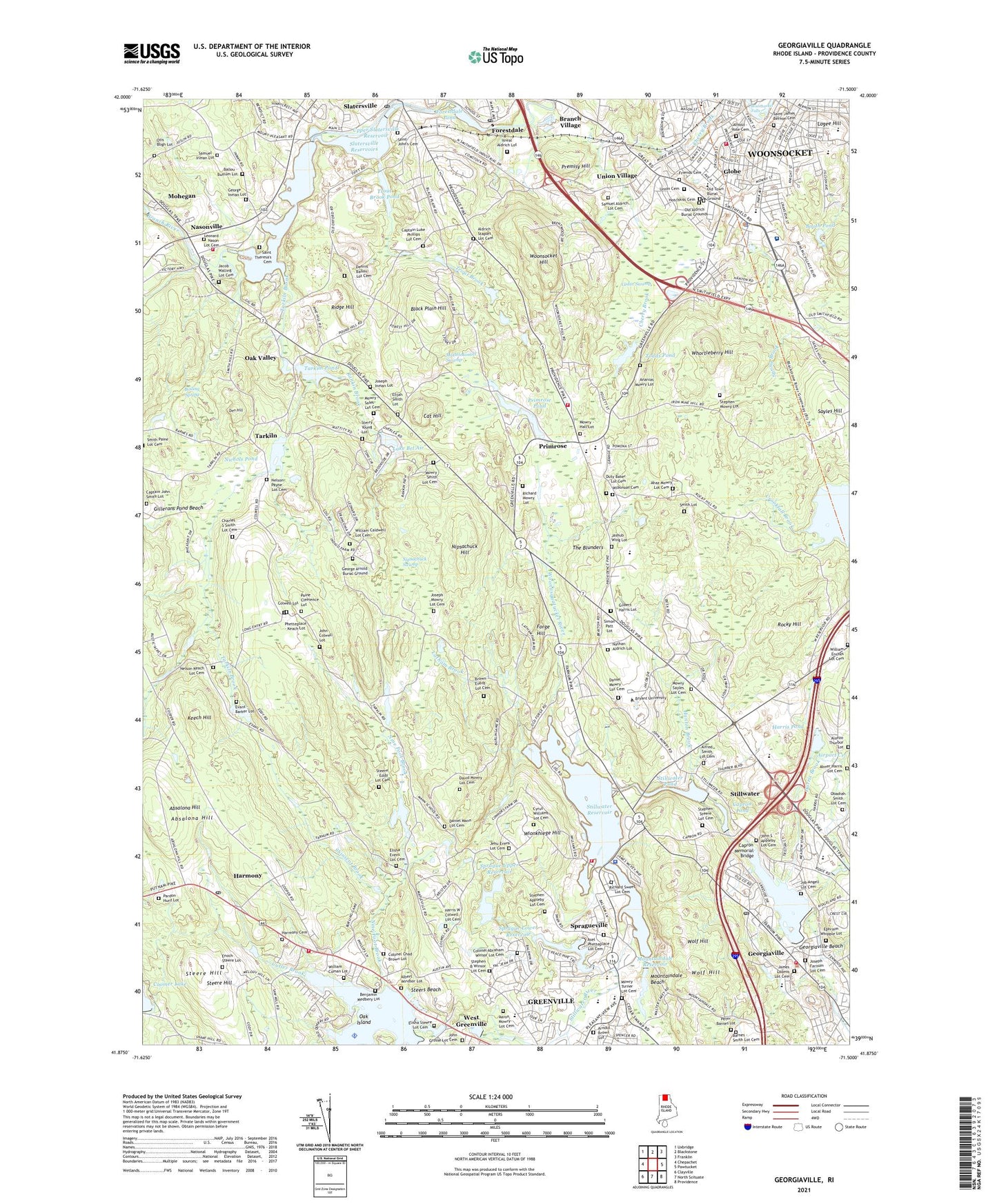
2024 topographic map quadrangle Georgiaville in the state of Rhode Island. Scale: 1:24000. Based on the newly updated USGS 7.5' US Topo map series, this map is in the following counties: Providence. The map contains contour data, water features, and other items you are used to seeing on USGS maps, but also has updated roads and other features. This is the next generation of topographic maps. Printed on high-quality waterproof paper with UV fade-resistant inks.
Quads adjacent to this one:
West: Chepachet
Northwest: Uxbridge
North: Blackstone
Northeast: Franklin
East: Pawtucket
Southeast: Providence
South: North Scituate
Southwest: Clayville
This map covers the same area as the classic USGS quad with code o41071h5.
Contains the following named places: Aaron Mowry Lot Cemetery, Abner Harris Lot Cemetery, Absalona Hill, Airport Creek, Albert Windsor Lot, Alfred Smith Lot Cemetery, Allenville Mill, Alonzo Thurbur Lot, Ananias Mowry Lot, Andrews School, Anna M McCabe School, Apple Valley, Arnold - Vose Cemetery, Arnold Brown Lot, Asel Phetteplace Lot Cemetery, Ballou - Buffum Lot, Barnes - Smith Lot Cemetery, Barry Field, Benjamin Medbery Lot, Bernon Heights School, Black Plain Hill, Boiling Spring, Booth Pond, Bourdon Boulevard Center Woonsocket Head Start, Branch Village, Brown - Evens Lot Cemetery, Bryant College, Burrillville Middle School, Capron Memorial Bridge, Capron Pond, Captain John Smith Lot, Cat Hill, Cedar Swamp, Charles S Smith Lot Cemetery, Colonel Abraham Winsor Lot Cemetery, Colonel Chad Brown Lot, Colwell Lot, Coomer Lake, Curran Lower Reservoir, Curran Lower Reservoir Dam, Cutler Brook, Cyrus Williams Lot Cemetery, Daniel Mann Lot Cemetery, Daniel Mowry Lot Cemetery, David Mowry Lot Cemetery, Dawley Brook, Den Hill, Elijah Smith Lot, Elisha Evens Lot Cemetery, Elisha Steere Lot Cemetery, Enoch Steere Lot, Ephraim Whipple Lot, Evans - Barker Lot, Field Station, Fifth Avenue School, Forestdale, Forestdale Mill Village Historic District, Forestdale Pond, Forestdale Pond Dam, Forge Hill, George Inman Lot, Georgiaville, Georgiaville Beach, Georgiaville Historic District, Georgiaville Pond, Georgiaville Pond Dam, Gilbert Harris Lot, Globe, Globe Park, Globe Park School, Gloucester Country Club, Gould Brook, Greenville Census Designated Place, Greenville Shopping Center, Grove Street School, Hanora Mills, Hanton Brook, Harmony, Harmony Cemetery, Harmony Census Designated Place, Harris Brook, Harris Pond, Harris W Colwell Lot Cemetery, Harrisville Pre-School, Hunt Brook, Irving S Cook School, Island Place Historic District, Isreal Aldrich Lot, Jacob Walling Lot Cemetery, James Loomis Lot Cemetery, Jashub Wing Lot, Jaswells Farm, Jehu Evens Lot Cemetery, Job Angell Lot Cemetery, John Colwell Lot, John Grosse Lot Cemetery, John S Appleby Lot Cemetery, Joseph Farnum Lot Cemetery, Joseph Inman Lot, Joseph Mowry Lot Cemetery, Keech Hill, Kevin K Coleman Elementary School, Lake Bel Air, Landmark Medical Center Fogarty Campus, Latham Brook, Leonard Nason Lot Cemetery, Logee Hill, Market Square, Masters Regional Academy, Matteo's Farm, Mattetee Swamp Brook, Mattetokomitt Swamp, Melody Hill Golf Course, Mohegan, Monsignor Gadoury Regional Primary School, Mount Saint Charles School, Mountaindale, Mountaindale Beach, Mountaindale Reservoir, Mountaindale Reservoir Dam, Mowry - Hall Lot, Mowry Paine Brook, Mowry Sayles Lot Cemetery, Mowry Turner Lot Cemetery, Nasonville, Nathan Aldrich Lot, Nelson Keach Lot Cemetery, Nelson Payne Lot Cemetery, Nichols Pond, Nichols Pond Dam, Nine Foot Brook, Nipsachuck Hill, Nipsachuck Swamp, North Smithfield, North Smithfield Elementary School, North Smithfield Junior-Senior High School, North Smithfield Wildlife Marsh, Oak Island, Oak Valley, Obadiah Smith Lot Cemetery, Old Aldrich Burial Grounds, Old Country Road School, Old Town Burial Ground, Otis Bligh Lot, Paine Clemence Lot, Pardon Hunt Lot, Park Square Plaza Shopping Center, Peter Barnes Lot, Phetteplace - Keach Lot, Premisy Hill, Primrose, Primrose Pond, Primrose Pond Dam, Rankin Brook, Reaper Brook, Rehabilitation Hospital of Rhode Island, Richard Mowry Lot, Richard Sweet Lot Cemetery, Ridge Hill, River Island Park, Rocky Hill, Saint John's Cemetery, Saint Peters School, Saint Theresa's Cemetery, Samuel Inman Lot, Sayles Hill, Seven Cedars Christmas Tree Farm, Shinscot Brook, Simon Patt Lot, Slatersville Plaza Shopping Center, Slatersville Reservoir Middle Dam, Slatersville Reservoir Upper Dam, Slatersville Reservoirs, Slattersville Reservoir, Smith Lot, Smithfield, Smithfield Senior High School, South Main Street Historic District, Sprague Brook, Sprague Lower Reservoir, Sprague Lower Reservoir Dam, Sprague Upper Reservoir, Spragueville, Steere - Eddy Lot Cemetery, Steere Hill, Steere Orchard, Steers Beach, Stephen Appleby Lot Cemetery, Stephen B Winsor Lot Cemetery, Stephen Mowry Lot, Stephen Steere Lot Cemetery, Sterry Young Lot, Stillwater, Stillwater Pond, Stillwater Pond Dam, Stillwater Reservoir, Stillwater Reservoir Dam, Stillwater River, Tarkiln, Tarkiln Brook, Tarkiln Pond, Tarkiln Pond Dam, The Blunders, The Shrine, Todds Pond, Town of North Smithfield, Town of Smithfield, Trout Brook, Trout Brook Horse Farm, Trout Brook Pond, Union Cemetery, Union Village, Union Village Historic District, Upper Slatersville Reservoir, Upper Sprague Reservoir, Upper Sprague Reservoir Dam, Waterman Reservoir, Waterman Reservoir Dam, West Greenville, Whipple Brook, Whortleberry Hill, William Coman Lot, William Enches Lot Cemetery, Wionkhiege Hill, WJMF-FM (Smithfield), WLKW-AM (Providence), Wolf Hill, Woonsocket Falls, Woonsocket Hill, WWON-AM (Woonsocket), WWON-FM (Woonsocket), ZIP Codes: 02828, 02876, 02896, 02917