MyTopo
Worcester South Massachusetts US Topo Map
Couldn't load pickup availability
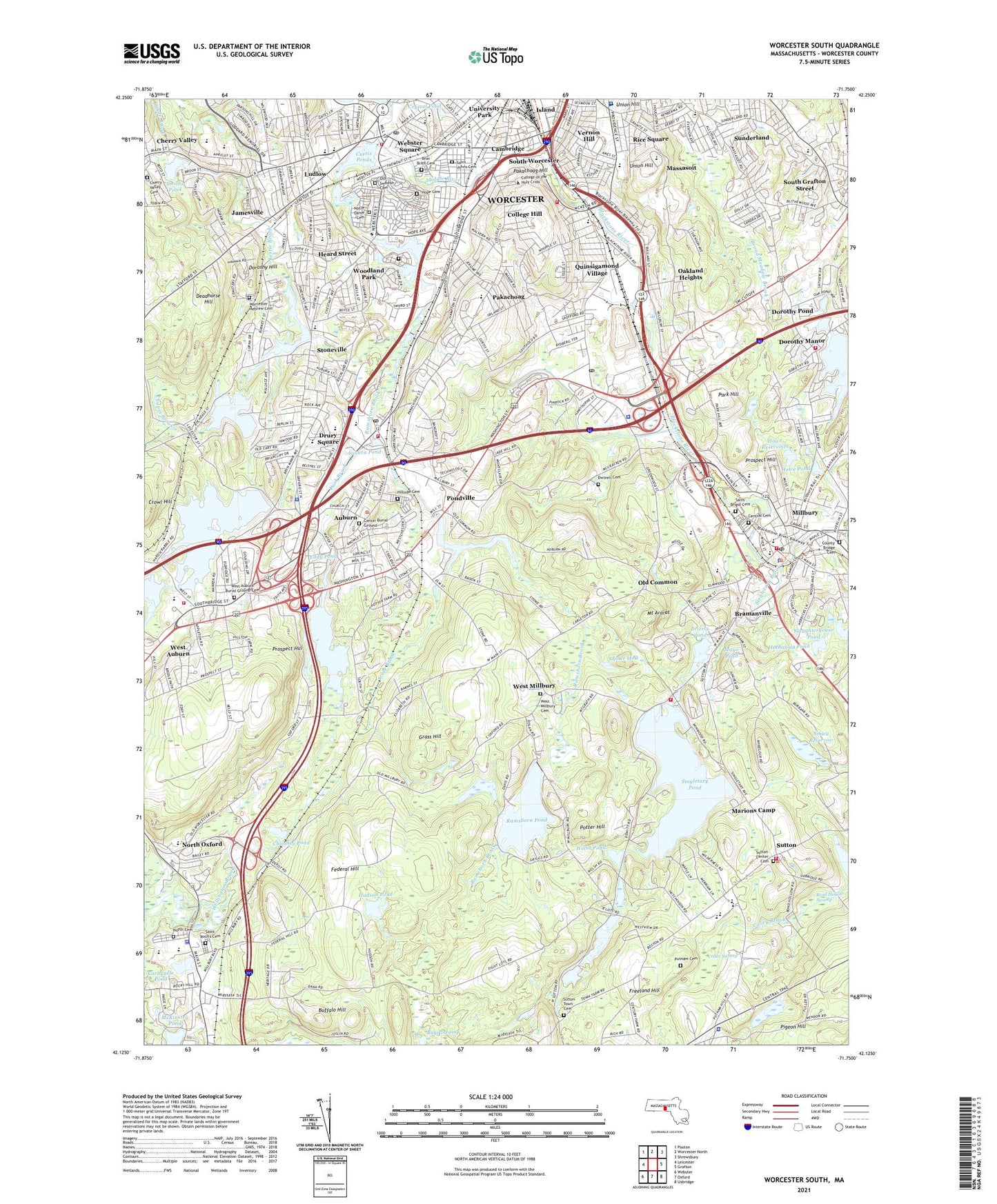
2024 topographic map quadrangle Worcester South in the state of Massachusetts. Scale: 1:24000. Based on the newly updated USGS 7.5' US Topo map series, this map is in the following counties: Worcester. The map contains contour data, water features, and other items you are used to seeing on USGS maps, but also has updated roads and other features. This is the next generation of topographic maps. Printed on high-quality waterproof paper with UV fade-resistant inks.
Quads adjacent to this one:
West: Leicester
Northwest: Paxton
North: Worcester North
Northeast: Shrewsbury
East: Grafton
Southeast: Uxbridge
South: Oxford
Southwest: Webster
This map covers the same area as the classic USGS quad with code k42071b7.
Contains the following named places: Adriatic Mills, All Faiths Cemetery and Crematory, Apricot Street Playground, Arnold Pond Dam, Assumption School, Auburn, Auburn High School, Auburn Industrial Park, Auburn Mall Shopping Center, Auburn Middle School, Auburn Plaza, Auburn Plaza Shopping Center, Auburn Pond, Auburn Pond Dam, Auburn Senior High School, Beaver Brook, Bennett Field, Blithewood School, Bnai Brith Cemetery, Bond Hollow Swamp, Boyce Street Park, Bramanville, Brierly Pond, Brierly Pond Dam, Broad Meadow Brook, Bryn Mawr Elementary School, Buffalo Hill, Bugs Swamp, Calvin Coolidge School, Cambridge, Cambridge Street School, Canterbury Street School, Carbuncle Pond, Casey Brook, Cedar Swamp, Center Burial Ground, Central Cemetery, Chapin Brook, Cherry Valley, Chimney Pond, Chimney Pond Dam, Clara Barton School, Clear View Country Club, College Hill, College of the Holy Cross, Cookson Field, Crompton Park, Crystal Pond, Crystal Street Historic District, Curtis Ponds, Curtis Ponds Dam, Dark Brook, Dark Brook Reservoir Dam, Dark Brook Reservoir Dike, Dark Dam, Deadhorse Hill, Dorothy Brook, Dorothy Hill, Dorothy Manor, Dorothy Pond, Dorthy School, Drury Square, Dwinell Cemetery, Eddy Pond, Elmwood Street School, Euclid Avenue-Montrose Street Historic District, Federal Hill, Federal Plaza, Federal Plaza Shopping Center, Fitton, Freegrace Marble Farm Historic District, Freeland Hill, Freeland Street School, Gaskin Field, Gates Lane Elementary School, Goddard School of Science and Technology, Grass Hill, Greenwood Industrial Park, Greenwood Park, Hadwen Park, Happy Day Child Care Center, Hathaway Pond, Hawk Hill Orchards, Heard Street, Heard Street Elementary School, Heritage Mall Shopping Center, Hillside Cemetery, Holy Name Center Catholic High School, Hope Cemetery, Hopeville Pond, Howe Pond, Howe Reservoirs, Hudson Pond, Hudson Pond Dam, Island, Jamesville, Jamesville Pond, Jamesville Station, Julia Bancroft School, Kettle Brook, Kinnear Brook, Leesville Pond, Leesville Pond Dam, Ludlow, Lynde Brook, Malvern School, Marions Camp, Mary D Stone School, Massasoit, Mayo Mill Number One Pond Dam, Mayo Pond, McGrath Education Center, McKinstry Pond, Mernill Pond State Reservation, Middle River, Middle River Park, Milbury Street School, Military Street School, Mill Brook, Millbury, Millbury Center School, Millbury Memorial High School, Millbury Savings - West Heliport, Mount Ararat, New Ludlow Elementary School, New Worcester, North Cemetery, North Oxford, Notre Dame Cemetery, Oakland Heights, Oakland Heights Playground, Old Common, Old Swedish Cemetery, Our Lady of the Angles School, Oxford Airport, Oxford High School, Oxford Sanitary Land Fill, Pakachoag, Pakachoag Golf Course, Pakachoag Hill, Park Hill, Pigeon Hill, Pondville, Pondville Pond, Pondville Pond Dam, Potter Hill, Pratt Brook, Prospect Hill, Putnam Cemetery, Quinsigamond Elementary School, Quinsigamond Pond, Quinsigamond Pond Dam, Quinsigamond Village, Ramshorn Brook, Ramshorn Pond, Ramshorn Pond Dam, Randall School, Rice School, Rice Square, Route 146 Shopping Center, Sacred Heart School, Saint Brigid Cemetery, Saint Johns Cemetery, Saint Roch's Cemetery, Saint Vincent Hospital, Shaw Memorial Elementary School, Shiner Hole, Sibley Reservoir, Singletary Brook, Singletary Pond, Singletary Pond Dam, Slaughterhouse Pond, Smiths Pond, South Grafton Street, South Plaza Shopping Center, South Worcester, South Worcester Playground, Stillwater Pond, Stone Brook, Stoneville, Stoneville Brook, Stoneville High School, Stoneville Pond, Stoneville Pond Dam, Stoneville Reservoir, Stowe Farm Orchard, Stump Hill, Sullivan Middle School, Sunderland, Sutton, Sutton Center Cemetery, Sutton Elementary School, Sutton Junior-Senior High School, Sutton Memorial School, Sutton Town Cemetery, Tatnuck Brook, The Fair Plaza, The Fair Shopping Center, The Fair Shopping Plaza Shopping Center, Town of Auburn, Town of Millbury, Town of Oxford, Town of Sutton, Trowbridgeville, Ty Cobb Park, Union Hill, Upper Stoneville Reservoir Dam, Upsala School, Valley Falls, Vernon Hill, Vernon Hill Elementary School, Vernon Hill Playground, View Street Historic District, WCHC-FM (Worcester), Webster Square, Webster Square Plaza Shopping Center, Welsh Pond, West Auburn, West Millbury, Wheelerville, Whispering Pines Estates Mobile Home Park, Windbrook Acres Mobile Home Park, Woodford Street Historic District, Woodland Park, WORC-AM (Worcester), Worcester Hebrew Cemetery, Worcester High School, Worcester Junior High School, Worcester South Shopping Center, ZIP Codes: 01501, 01527, 01590, 01603, 01607, 01610