MyTopo
Cedar Springs Michigan US Topo Map
Couldn't load pickup availability
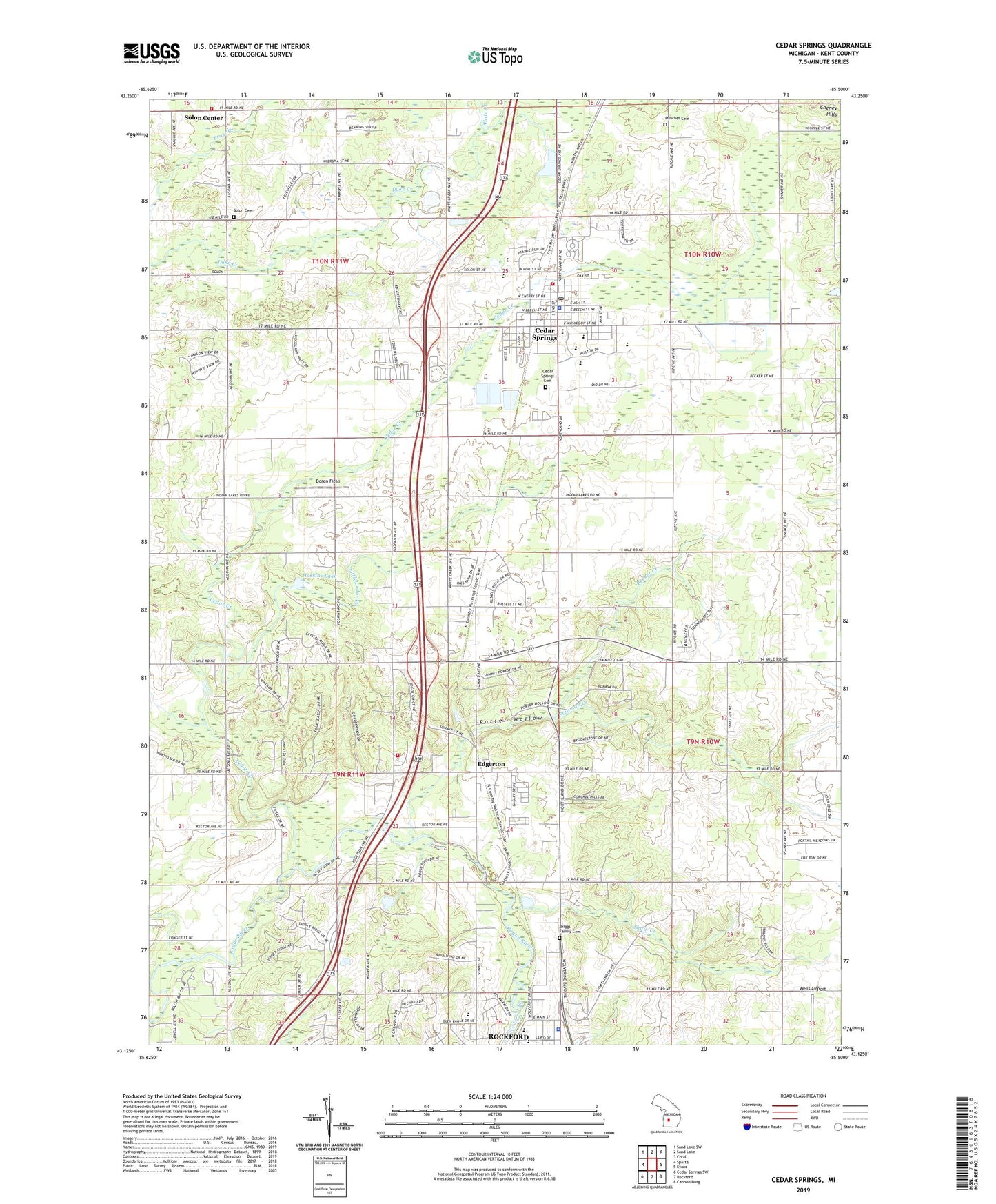
2023 topographic map quadrangle Cedar Springs in the state of Michigan. Scale: 1:24000. Based on the newly updated USGS 7.5' US Topo map series, this map is in the following counties: Kent. The map contains contour data, water features, and other items you are used to seeing on USGS maps, but also has updated roads and other features. This is the next generation of topographic maps. Printed on high-quality waterproof paper with UV fade-resistant inks.
Quads adjacent to this one:
West: Sparta
Northwest: Sand Lake SW
North: Sand Lake
Northeast: Coral
East: Evans
Southeast: Cannonsburg
South: Rockford
Southwest: Cedar Springs SW
This map covers the same area as the classic USGS quad with code o43085b5.
Contains the following named places: Algoma Post Office, Algoma School, Algoma Township Fire Department Station 2, Beach Elementary School, Becker Creek, Brae Side Golf Course at Cortland Hills, Briggs Family Cemetery, Burch's Post Office, Cedar Creek, Cedar Creek Community Church, Cedar Springs, Cedar Springs Cemetery, Cedar Springs Christian Church, Cedar Springs City Hall, Cedar Springs Fire Department, Cedar Springs High School, Cedar Springs Library, Cedar Springs Middle School, Cedar Springs Mobile Estates, Cedar Springs Police Department, Cedar Springs Post Office, Cedar Springs Station, Cedar Trails Elementary School, Cedar View Elementary School, Cedarfield Mobile Home Park, Chauteau Algoma Estates Mobile Home Park, Cheney Hills, City of Cedar Springs, City of Rockford, Doren Field, Duke Creek Campgrounds, Edgerton, Edgerton Post Office, Edgerton Station, First Baptist Church, Free Methodist Church, Glen Park, Grace Evangelical Free Church, Grand Rapids and Indiana Railroad Culvert Historical Marker, Hillcrest Community Church, Hoskins Lake, Kingdom Hall, Lakeside Camp Park, Little Cedar Creek, Metro Health Cedar Springs, Michigan State Police District 6 Headquarters and Rockford Post 61, Morley Park, North Kent Golf Course, Our Lady of Consolation Catholic Church, Our Lady of Consolation School, Parkside Elementary School, Pilgrim Bible Church, Pioneer Church, Porter Hollow, Punches Cemetery, Red Hawk Elementary School, Rockford Family Medicine, Rockford Public Schools Administration Building, Rockford Reformed Church, Rockford Rest Area, Rockford Springs Community Church, Shaw Creek, Solid Rock Worship Center, Solon Center, Solon Center Wesleyan Church, Solon Township Cemetery, Solon Township Fire Department, Stegman Creek, Township of Algoma, United Methodist Church, Valley View School, Velzy Post Office, Wells Airport, White Creek, ZIP Code: 49319