MyTopo
Greenville West Michigan US Topo Map
Couldn't load pickup availability
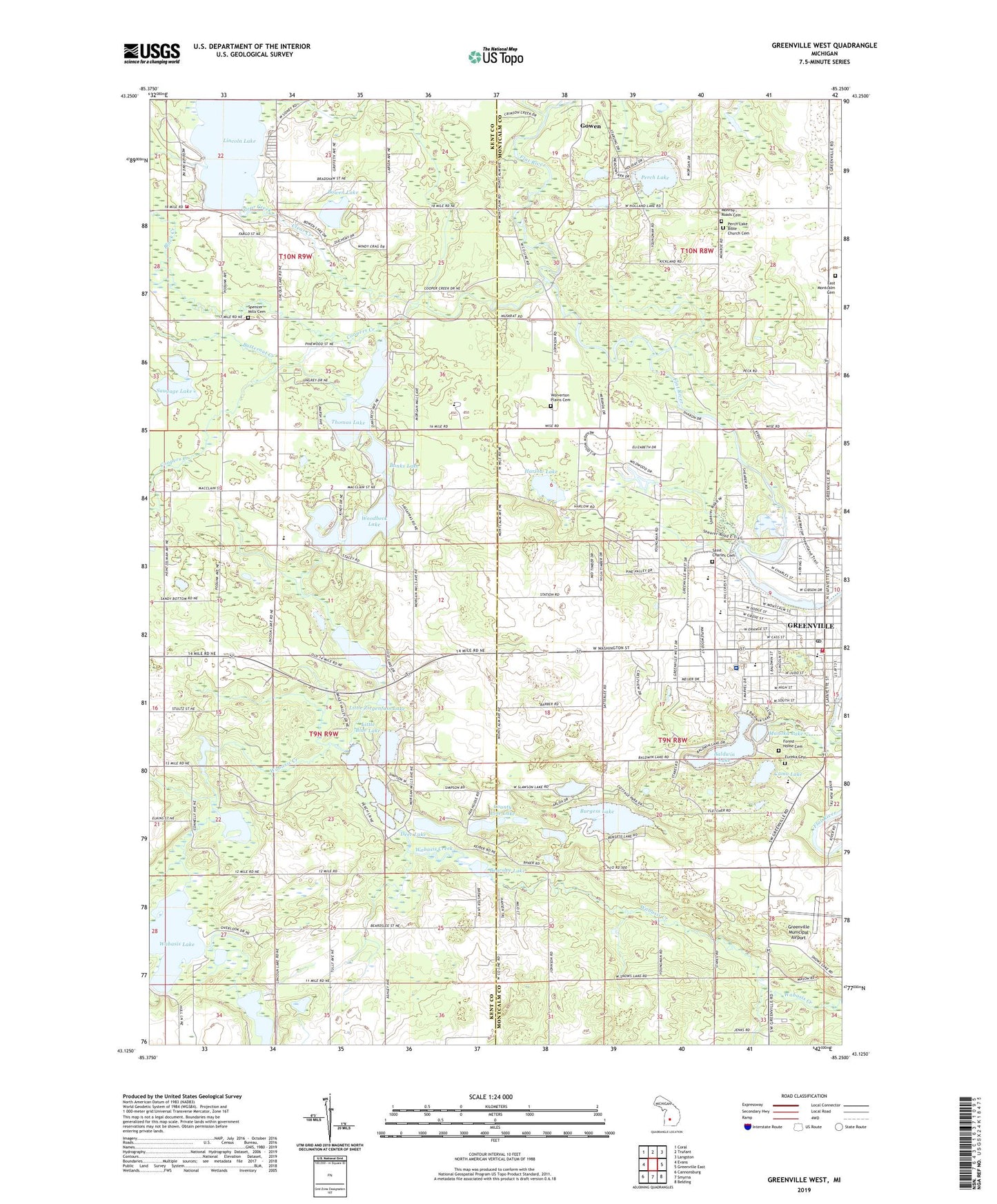
2023 topographic map quadrangle Greenville West in the state of Michigan. Scale: 1:24000. Based on the newly updated USGS 7.5' US Topo map series, this map is in the following counties: Montcalm, Kent. The map contains contour data, water features, and other items you are used to seeing on USGS maps, but also has updated roads and other features. This is the next generation of topographic maps. Printed on high-quality waterproof paper with UV fade-resistant inks.
Quads adjacent to this one:
West: Evans
Northwest: Coral
North: Trufant
Northeast: Langston
East: Greenville East
Southeast: Belding
South: Smyrna
Southwest: Cannonsburg
This map covers the same area as the classic USGS quad with code o43085b3.
Contains the following named places: Ash Technology and Learning Center, Baldwin Heights School, Baldwin Lake, Baldwin Lake Beach, Banks Lake, Bearslee Lake, Belgreen Seventh Day Adventist Church, Black Creek, Bowen Lake, Burgess Lake, Butternut Creek, Calvary Baptist Church, Camp Concordia, Church of Jesus Christ of Latter Day Saints, Church of Nazarene, City of Greenville, Clear Creek, Como Lake, Coopers Creek, County Line Lake, Deer Lake, East Montcalm Cemetery, Eureka Cemetery, Eureka Township Hall, Faith Baptist Church, Fighting Falcon Military Museum, First Baptist Church, First Church of God, First Congregational Church, Flat River Community Library, Flat River Family Care, Flat River Historical Museum, Forest Home Cemetery, Greenbriar Estates Mobile Home Park, Greenville, Greenville City Hall, Greenville Country Club, Greenville Department of Public Safety, Greenville Family Care Center, Greenville High School, Greenville Historical Marker, Greenville Middle School, Greenville Municipal Airport, Greenville Post Office, Greenville Public Safety Department Fire Station, Greenville Public Safety Department Police Station, Greenville Station, Greenwood Camp, Halfmile Lake, Hansen Park, Harlow Lake, Heritage Park, Hillcrest Free Methodist Church, Horseshoe Lake, Liberty Baptist Church, Lincoln Heights School, Lincoln Lake, Lincoln Lake Post Office, Lincoln Lake Station, Links of Bowen Lake, Little Blue Lake, Little Wabasis Lake, Little Ziegenfuss Lake, Manoka Lake, Maranatha Chapel, Monroe Roads Cemetery, Montcalm County 4H Fairgrounds, Morgan Lake, Mount Calvary Lutheran Church, Mount Calvary Lutheran School, Oakfield Township Museum, Perch Lake, Perch Lake Bible Church Cemetery, Perch Lake Church, Saint Charles Catholic Cemetery, Saint Charles Catholic Church, Saint Charles Catholic School, Saint Paul Lutheran Church, Saint Paul's Episcopal Church, Saint Paul's Episcopal Church Historical Marker, Saint Peters Church, Satterlee School, Saugage Lake, Sheriffs Camp, Spectrum Health United Hospital, Spencer Mills Cemetery, Spencer Mills Church, Spencer Township Fire Department, Spencer Township Library, Spencers Mill Post Office, Tek-E-Nink Lake, Thomas Lake, Tower Park, Tower Riverside Park, Township of Eureka, Township of Oakfield, United Methodist Church, Veteran's Park, West Washington Cemetery, White Pine Park, Wolverton Plains Cemetery, Woodbeck Lake, WPLB-AM (Greenville), Ziegenfuss Lake, ZIP Codes: 48838, 49326