MyTopo
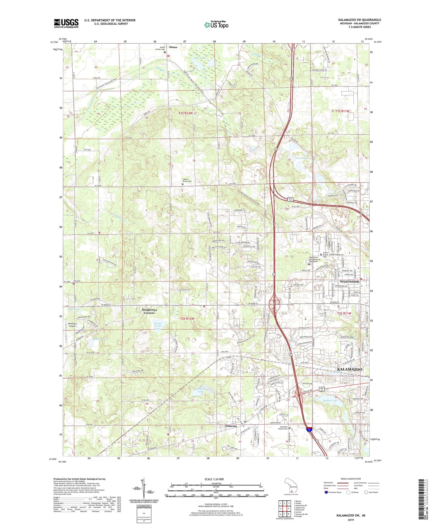
Kalamazoo SW Michigan US Topo Map
Couldn't load pickup availability
2023 topographic map quadrangle Kalamazoo SW in the state of Michigan. Scale: 1:24000. Based on the newly updated USGS 7.5' US Topo map series, this map is in the following counties: Kalamazoo. The map contains contour data, water features, and other items you are used to seeing on USGS maps, but also has updated roads and other features. This is the next generation of topographic maps. Printed on high-quality waterproof paper with UV fade-resistant inks.
Quads adjacent to this one:
West: Gobles East
Northwest: Merson
North: Otsego
Northeast: Kalamazoo NE
East: Kalamazoo
Southeast: Portage
South: Schoolcraft NW
Southwest: Lawton
This map covers the same area as the classic USGS quad with code o42085c6.
Contains the following named places: Agape Christian Church, Alamo Center Cemetery, Alamo Rest Area, Alamo Station, Alamo Township Fire Department, Alamo Valley School, Americana Estates Mobile Home Park, Arcadia Elementary School, Asylum Lake, Bonnie Castle Lake, Charter Township of Oshtemo, Chime Street School, Church of God Westwood, Colonial Manor Mobile Home Park, Cooper School, Davenport University-Kalamazoo Campus, Doughertys Corners, Dustin Lake, Faith Church, Fountain Springs Mobile Home Park, Franklin Valley Estates Mobile Home Park, Frays Park, Genessee Prairie Cemetery, Grand Prairie Cemetery, Grand Prairie Golf Course, Grand Prairie School, Harris Family Historical Marker, Heritage Christian Reformed Church, Hill Cemetery, Huntington Run Mobile Home Park, Hurd School, Immanuel Lutheran Church, Indian Prairie School, Judson Church, Kalamazoo Central High School, Kalamazoo Chinese Christian Church, Kalamazoo Post Office Oshtemo Station, Kalamazoo Post Office Westwood Station, Kalamazoo Protestant Reformed Church, Kalamazoo Region Historical Marker, Kalamazoo Speedway, King-Westwood School, Latvian Evangelical Lutheran Church, Liberty Street Cemetery, Meadow View Village Mobile Home Park, Mount Ever - Rest Memorial Park North, Mud Lake, Mud Lakes, New Day Church, Newman's Airport, Northwest Oshtemo Church, Oshtemo, Oshtemo Branch Library, Oshtemo Township Fire Department Station 1 Headquarters, Oshtemo Township Fire Department Station 2, Oshtemo Township Fire Department Station 3, Prairies Golf Club, Ravine Road Baptist Church, Saint Martin of Tours Church, Second Christian Reformed Church, Seventh-Day Adventist Church, South Lake, Temple B'Nai Israel, Tendercare Kalamazoo, Thornapple Creek Golf Club, Township of Kalamazoo Fire Department - Station 4 - Westwood, Twelfth Street Baptist Church, Twin Lakes, Twin Lakes Church, Valley View Church, West Town Mall, Western Michigan University-Parkview Campus, Westwood, Westwood Census Designated Place, Westwood Christian Reformed Church, Westwood United Methodist Church, WGVK-TV (Kalamazoo), Williams Post Office, Williams Station, Wyman Lake, ZIP Codes: 49006, 49009