MyTopo
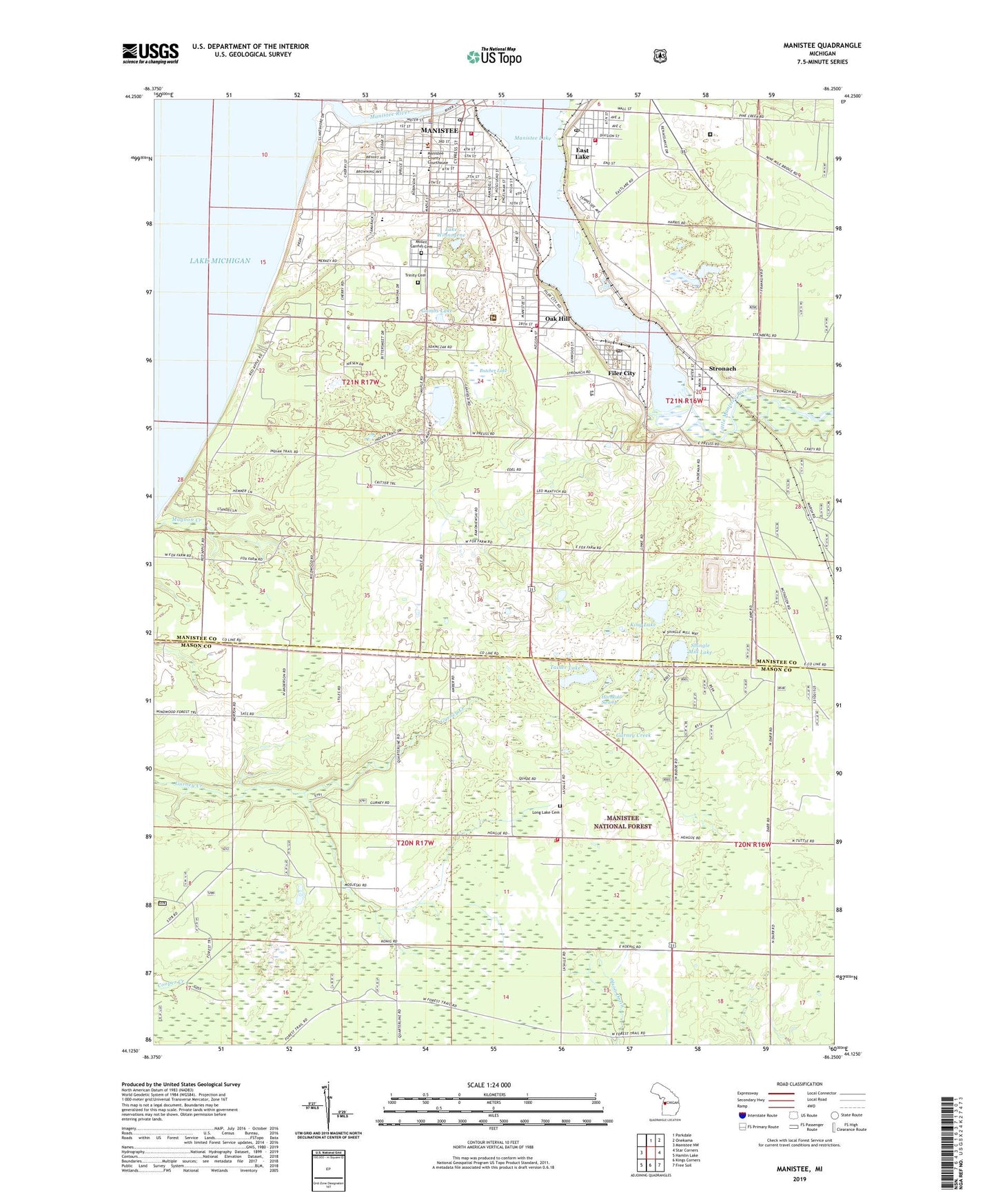
Manistee Michigan US Topo Map
Couldn't load pickup availability
Also explore the Manistee Forest Service Topo of this same quad for updated USFS data
2023 topographic map quadrangle Manistee in the state of Michigan. Scale: 1:24000. Based on the newly updated USGS 7.5' US Topo map series, this map is in the following counties: Manistee, Mason. The map contains contour data, water features, and other items you are used to seeing on USGS maps, but also has updated roads and other features. This is the next generation of topographic maps. Printed on high-quality waterproof paper with UV fade-resistant inks.
Quads adjacent to this one:
West: Manistee NW
North: Parkdale
Northeast: Onekama
East: Star Corners
Southeast: Free Soil
South: Kings Corners
Southwest: Hamlin Lake
This map covers the same area as the classic USGS quad with code o44086b3.
Contains the following named places: Ayres School, Buitema Dock and Dredge Company, Butcher Lake, Canfield Lake, Central High School, Century Boat Company, Charter Township of Filer, City of Manistee, Clark Equipment Company, Driftwood Village Mobile Home Park, East Lake, Eastlake Fire and Rescue, Eastlake Post Office, Eastlake Station, Faith Covenant Church, Filer City, Filer City Census Designated Place, Filer City Post Office, Filer City Station, Filer Township Fire Department, Filer Township Hall, First Congregational Church, First Congregational Church Historical Marker, First Street Beach, Flynn School, Fox Hills Golf Course, Gambs Lake, Good Shepherd Lutheran Church, Grant Township Fire and Rescue, Guardian Angel School, Guardian Angels Church, Hardy Salt Company, Holy Trinity Episcopal Church, Holy Trinity Episcopal Church Historical Marker, Hornkohl Swamp, Jefferson School, Jehovah's Witnesses, King Lake, Lake Winnogene, LaSalle School, Lincoln School, Little Manistee River, Little River Band Health Center, Long Lake Cemetery, Madison School, Mangoon Creek Park, Manistee, Manistee Assembly of God Church, Manistee City Hall, Manistee City Library Historical Marker, Manistee County Courthouse, Manistee County Library, Manistee County Museum, Manistee Drop Forge Corporation, Manistee Fire Department, Manistee Fire Hall Historical Marker, Manistee Golf and Country Club, Manistee High School, Manistee Lake, Manistee Middle School, Manistee National Forest District Ranger Station, Manistee National Golf and Resort, Manistee Police Department, Manistee Post Office, Manistee River State Game Area, Manistee Station, Manistee United Methodist Church, Manisteel Incorporated, Marsh, Martin Marietta Chemicals, Morton Chemical Company, Morton Salt Company, Mount Carmel Catholic Cemetery, New Life Tabernacle Church, North Riverwalk and Memorial Park, Oak Hill, Oak Hill Census Designated Place, Oakhill Post Office, Oaks Correctional Facility, Old Freesoil School, Our Savior's Historical Museum, Our Saviour's Lutheran Church Historical Marker, Packaging Corporation of America, Ramsdell Theatre Historical Marker, Ramsdell Theatre Opera House, Rietz Park, Saint Joseph Catholic Church, Saint Paul's Lutheran Church, Sands Park, Seventh Day Adventist Church, Shingle Mill Lake, Stronach, Stronach Census Designated Place, Stronach Post Office, Stronach Station, Stronach Township Fire Department, Sundling Park, Tainer Lake, Trinity Cemetery, Trinity Lutheran Church, Trinity School, United States Forest Service Manistee Ranger Station, Village of Eastlake, William Douglas House Historical Marker, WMTE-AM (Manistee), WRRK-FM (Manistee), ZIP Codes: 49626, 49634