MyTopo
Saint Charles Michigan US Topo Map
Couldn't load pickup availability
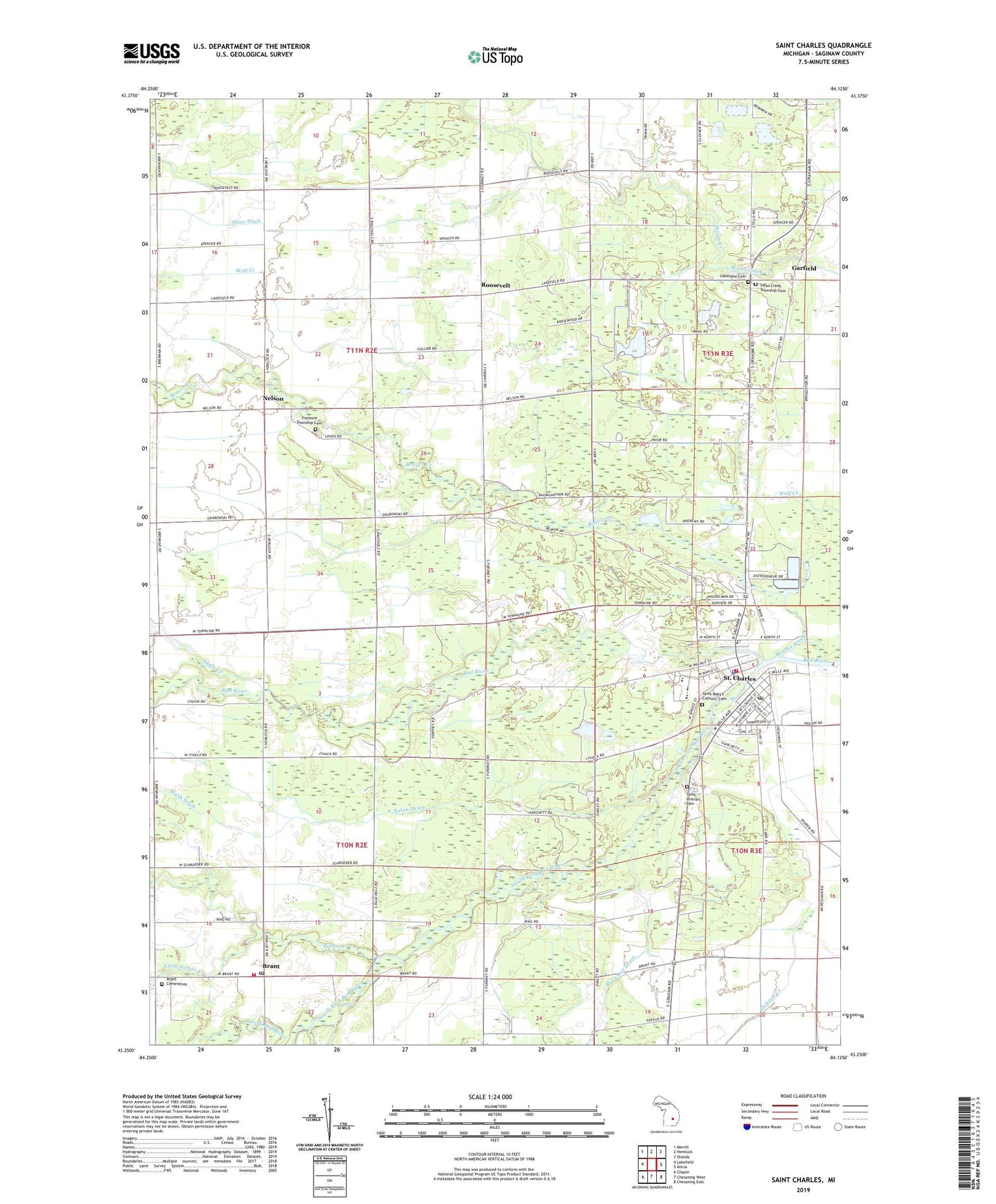
2023 topographic map quadrangle Saint Charles in the state of Michigan. Scale: 1:24000. Based on the newly updated USGS 7.5' US Topo map series, this map is in the following counties: Saginaw. The map contains contour data, water features, and other items you are used to seeing on USGS maps, but also has updated roads and other features. This is the next generation of topographic maps. Printed on high-quality waterproof paper with UV fade-resistant inks.
Quads adjacent to this one:
West: Lakefield
Northwest: Merrill
North: Hemlock
Northeast: Shields
East: Alicia
Southeast: Chesaning East
South: Chesaning West
Southwest: Chapin
This map covers the same area as the classic USGS quad with code o43084c2.
Contains the following named places: Beaver Creek, Blackmer Drain, Brant, Brant Cemeteries, Brant Post Office, Brant Township Hall, Coal Mine Number Eight Historical Marker, Dygert Drain, Eagle Creek, Eastwood Post Office, Eaton Drain, Faith Fellowship Assembly of God Church, Fergus, Fergus Post Office, First Baptist Church, Fowler Schoolhouse Historical Marker, Fremont Township Cemetery, Garfield, Garfield Station, Guardian Angels Church, Hartley Outdoor Recreation Center, Hope Church, Immaculate Conception Church, Kimberly Oaks Golf Club, Lakefield Cemetery, Little Potato Creek, Lumberjack Park, Mina J Miller Elementary School, Nativity Lutheran Church, Nelson, Nelson Post Office, Nelson United Methodist Church, Orr Post Office, Potato Creek, Riverside Cemetery, Roosevelt, Roosevelt Post Office, Saginaw Valley Coal Historical Marker, Saint Charles, Saint Charles Elementary School, Saint Charles Family Practice, Saint Charles Health Center, Saint Charles High School, Saint Charles Historical Museum, Saint Charles Police Department, Saint Charles Post Office, Saint Charles Public Library, Saint Charles Station, Saint Charles United Methodist Church, Saint Charles Waterfowl Observatory, Saint Mary's Catholic Cemetery, Schroeder House Historical Marker, Seventh Day Adventist Church, Short Ditch, South Fork Bad River, Swan Creek Township Cemetery, Swan Creek Township Park, Thurston Middle School, Township of Brant, Township of Fremont, Township of Swan Creek, Tri - Township Fire Department Station 1, Tri - Township Fire Department Station 2, Trinity Church, United Methodist Church, Village of Saint Charles, Village Park, Webb Drain, ZIP Code: 48655