MyTopo
Austin East Minnesota US Topo Map
Couldn't load pickup availability
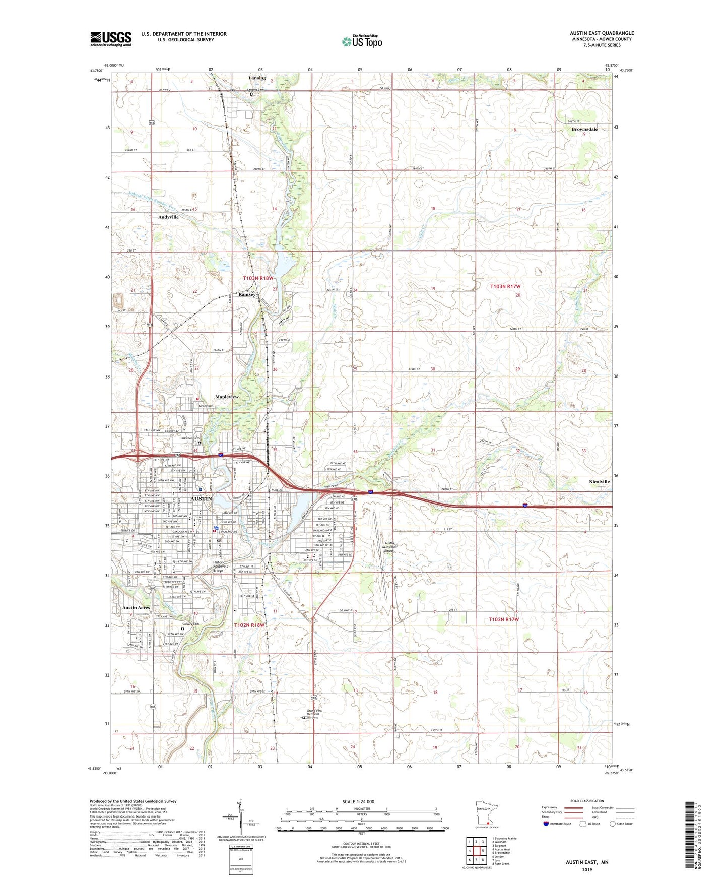
2022 topographic map quadrangle Austin East in the state of Minnesota. Scale: 1:24000. Based on the newly updated USGS 7.5' US Topo map series, this map is in the following counties: Mower. The map contains contour data, water features, and other items you are used to seeing on USGS maps, but also has updated roads and other features. This is the next generation of topographic maps. Printed on high-quality waterproof paper with UV fade-resistant inks.
Quads adjacent to this one:
West: Austin West
Northwest: Blooming Prairie
North: Waltham
Northeast: Sargeant
East: Brownsdale
Southeast: Rose Creek
South: Lyle
Southwest: London
This map covers the same area as the classic USGS quad with code o43092f8.
Contains the following named places: Andyville, Arthur Winfield Wright House, Austin, Austin Baptist Chapel, Austin Christian Fellowship, Austin Church of Christ, Austin City Police Department, Austin Country Club, Austin Fire Department, Austin Mobile Home Park, Austin Municipal Airport, Austin Police Department, Austin Post Office, Austin Public Library, Austin Senior High School, Austin State Junior College, Banfield School, Beautiful Saviors Church, Bethlehem Free Church, Burr Oaks School, Calvary Cemetery, Cedar River Church of Christ, Cedar River Dam, Chateau Speedway, Christ Episcopal Church, City of Austin, City of Mapleview, Comforcare Good Samaritan Center, Community Park, Countryside Mobile Home Park, Crane Community Chapel, Crane Park, Cullen Park, Decker Park, Dobbins Creek, Dobbins Creek Dam, Dreisner Park, East Side Lake, East Side Lake Park, Ellis Junior High School, Evangelical Community Church, Faith Church, Faith Church of Austin, Fayette Sherman Park, Fellowship Church, First Baptist Church of Austin, First United Church, Galloway Park, Garard School, Grace Baptist Church, Grace Church, Grand View Memorial Gardens, Hillside Park, Historic Roosevelt Bridge, Holy Cross Church, Holy Cross School, Horace Austin Park, Hormel Historic Home, Jay C Hormel Nature Center, Judicial Ditch Number Five, Kaufman Park, Keys to Life Apostolic Church, Kingdom Hall of Jehovahs Witnesses, KQAQ-AM (Austin), Lafayette Park, Lakeside Center, Lansing, Lansing Cemetery, Lansing Census Designated Place, Lansing Corners, Lansing Post Office, Lansing Town Hall, Lions Park, Mapleview, Mapleview City Hall, Mapleview Fire Department, Marcusen Park, Mayo Clinic Health System Austin, Mill Pond, Mousenik Launch Site, Mower County Courthouse, Mower County Fairgrounds, Mower County Historical Center, Mower County Jail, Mower County Veterans Memorial, Mower Law Enforcement Center, Murphy Creek, Nevelin Elementary School, Neveln Park, New Life Vineyard Christian Fellowship, Nicolville, North West Park, Northwest Church of Christ, Oak Grove School, Oak Park Mall, Oakwood Cemetery, Open Bible Church, Our Savior's Lutheran Church, Pacelli High School, Prairie View School, Queen of Angels Catholic Church, Queen of Angels School, Ramsey, Ramsey Dam, Ramsey Golf Club, Ramsey Mill Pond, Ramsey Post Office, Rydjor Bike Museum, Sacred Heart Care Center, Saint Augustine - Saint Edward School, Saint Augustine's Church, Saint John's Lutheran Church, Saint Mark's Lutheran Home, Saint Olaf Hospital Heliport, Saint Olaf Lutheran Church, Saint Paul's Evangelical Church, Saint Paul's Lutheran School, Salvation Army Corps Church, School Number 101, Shaw School, South Grove Park, Southgate School, Spam Museum, Sterling Park, Sterling Shopping Center, Sulton Park, Sumner School, Todd Park, Township of Lansing, Turtle Creek, United Church of God, United Methodist Church, Victory Christian Church, Westminster Presbyterian Church, Wolf Creek, Woodson School, ZIP Codes: 55912, 55950