MyTopo
Orchard Lake Minnesota US Topo Map
Couldn't load pickup availability
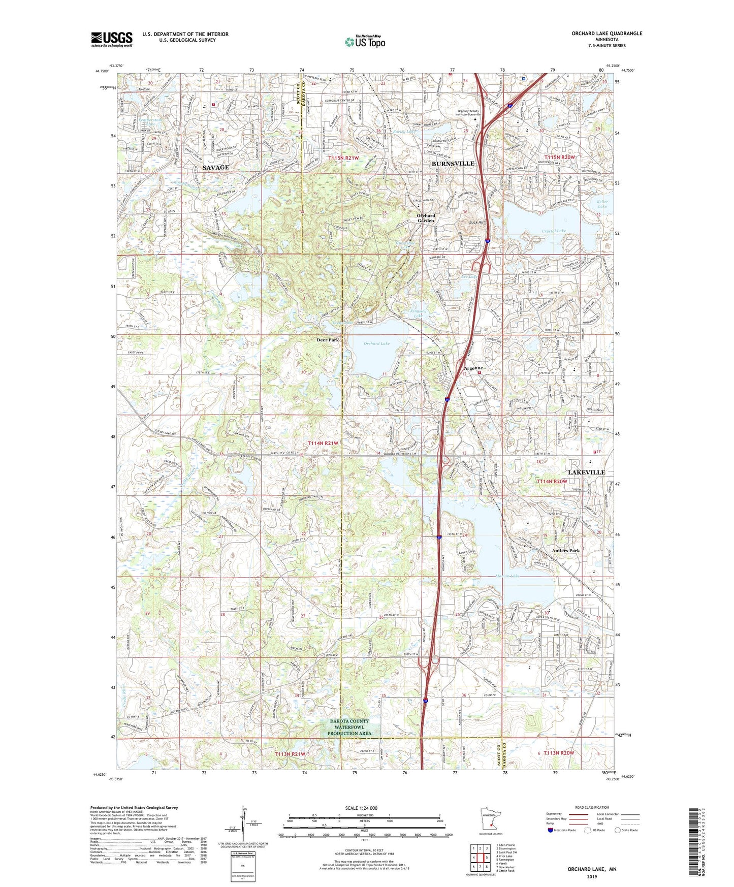
2022 topographic map quadrangle Orchard Lake in the state of Minnesota. Scale: 1:24000. Based on the newly updated USGS 7.5' US Topo map series, this map is in the following counties: Dakota, Scott. The map contains contour data, water features, and other items you are used to seeing on USGS maps, but also has updated roads and other features. This is the next generation of topographic maps. Printed on high-quality waterproof paper with UV fade-resistant inks.
Quads adjacent to this one:
West: Prior Lake
Northwest: Eden Prairie
North: Bloomington
Northeast: Saint Paul SW
East: Farmington
Southeast: Castle Rock
South: New Market
Southwest: Veseli
This map covers the same area as the classic USGS quad with code o44093f3.
Contains the following named places: Antlers Park, Argonne, Aurora Village Center Shopping Center, Berean Church, Bracketts Crossing Golf Club, Buck Hill, Buck Hill Ski Area, Burnhaven Shopping Center, Burnhill Plaza Shopping Center, Burnhill Shoppers Corner Shopping Center, Burnside Plaza Shopping Center, Burnsville Alimagnet Park, Burnsville Center Shopping Center, Burnsville Chamber of Commerce, Burnsville Crossings Shopping Center, Burnsville Fire Department Station 1, Burnsville Marketplace Shopping Center, Byerlys Burnsville Center Shopping Center, Cam Ram Park, Casperson Park, Century Middle School, Christina Huddleston Elementary, City of Credit River, City of Lakeville, Cobblestone Court Shopping Center, Crystal Lake, Crystal Lake Church, Crystal Lake Elementary School, Crystal Lake Golf Course, Crystal Lake Seaplane Base, Crystal Lake West Park, Dakota County Waterfowl Production Area, Day Park, Deer Park, Earley Lake, Eastview Elementary School, Echo Park Elementary School, Fairview Ridges Hospital, Featherstone Lake, Glendale Township, Glory Academy, Good Shepherd Church, Good Shepherd Lutheran School, Grace Church, Hanrahan Lake, Harriet Bishop Elementary School, Hilgenberg Pond Dam, Hollows Park, Holy Cross Church, Honeywell Country Club, Horseshoe Lake, Judd Post Office, Judicial Park, Keller Lake, Kensington Park, Kenwood Center Shopping Center, Kenwood Trail Junior High School, Kenwood Trail Middle School, King Park, Kingsley Lake, Krenz Lake, Lake Marion Elementary School, Lake Marion Seaplane Base, Lakeside Park, Lakeview Elementary School, Lakeville Fire Department Station 3, Lakeville Fire Department Station 4 Headquarters, Lakeville North High School, Lakeville Senior High School, Lakeville South High School, Lee Lake, Legends Golf Course, Loop Park, Marion Lake, McAndrews Center Shopping Center, Meadows Park, Minneapolis Gun Club, Murphy Lake, Murphy-Hanrehan Regional Park Reserve, New Spirit United Church of Christ, North Park, Northview Park, Oak Shores Park, Orchard Garden, Orchard Gardens Golf Course, Orchard Lake, Orchard Lake Elementary School, Orchard Lake School, Paha Sapa Park, Redeemer Church, Ritter Farm Park, Rollings Oaks Park, Rose Park, Saint Mary Magdalene Lutheran Church, Savage Fire Department - Station 2 - O'Connell Road, Skyline Plaza Shopping Center, Southcross Shoppes Shopping Center, Southfork Shopping Center, Southview Christian School, Summit Oaks Square Shopping Center, Township of Credit River, Trinity Church, Twin Lakes Park, Wallace Henry Pond Dam, West Lake Marion Park, Wood Park, Wood Park Pond, ZIP Codes: 55044, 55306