MyTopo
Blue Mountain Mississippi US Topo Map
Couldn't load pickup availability
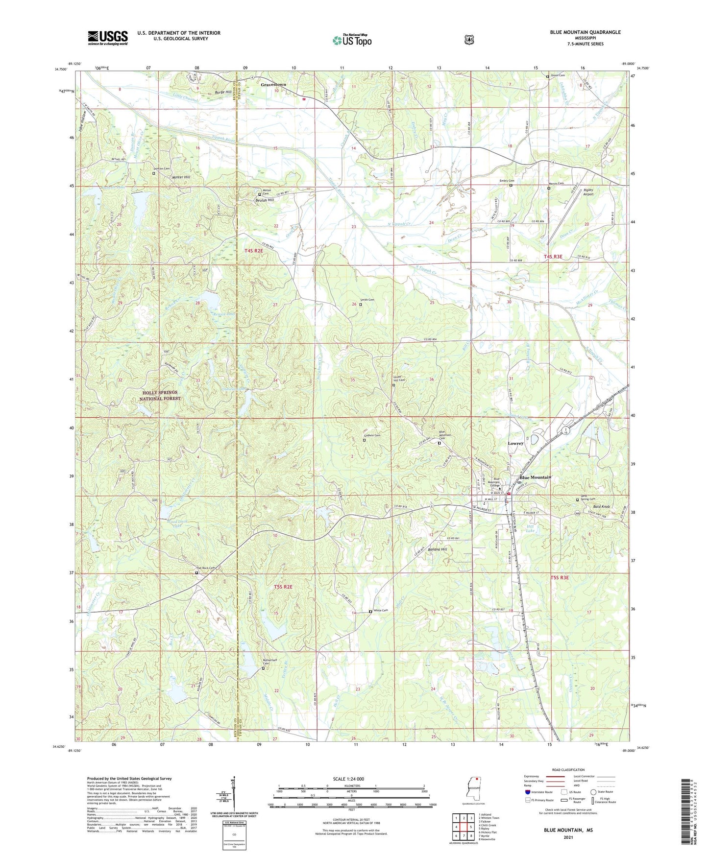
2021 topographic map quadrangle Blue Mountain in the state of Mississippi. Scale: 1:24000. Based on the newly updated USGS 7.5' US Topo map series, this map is in the following counties: Tippah, Benton. The map contains contour data, water features, and other items you are used to seeing on USGS maps, but also has updated roads and other features. This is the next generation of topographic maps. Printed on high-quality waterproof paper with UV fade-resistant inks.
Quads adjacent to this one:
West: Chilli Creek
Northwest: Ashland
North: Whitten Town
Northeast: Falkner
East: Ripley
Southeast: Keownville
South: Myrtle
Southwest: Hickory Flat
Contains the following named places: Bald Knob, Banana Hill, Baumann Lake Dam, Beulah Hill, Beulah Hill Church, Beulah Land Church, Bill Creek, Blue Mountain, Blue Mountain Cemetery, Blue Mountain Childrens Home, Blue Mountain Church, Blue Mountain College, Blue Mountain Elementary School, Blue Mountain High School, Blue Mountain Police Department, Blue Mountain Post Office, Blue Mountain United Methodist Church, Blue Mountain Volunteer Fire Department, Booth Chapel, Brougher Creek, Burge Hill, Central Church, Coomb Branch, Dean Creek, Duncan Branch, Duncan Cemetery, Duncan Lake, Embry Cemetery, Embry Creek, Flat Rock Cemetery, Flat Rock Church, Flatwood Grove Church, Godwin Cemetery, Godwin Creek, Godwin Lake, Gravestown, Gravestown Volunteer Fire Department, Gray Creek, Guyton, Harrison, Hell Creek Watershed LT-9b-4 Dam, Hell Creek Watershed LT-9b-5 Dam, Hell Creek Watershed LT-9b-6 Dam, Hill Lake, Hobson Branch, Hobson Lake Dam, Ishitubba Creek, Jobe Hollow, Little Channel, Lower Tippah River Lt-7-18, Lowrey, Lowrey Memorial Baptist Church, LT 6-5 Dam, LT 7-7 Dam, LT 8-11 Dam, Macedonia, Macedonia Church, Marvin Cemetery, May Creek, McAllister Creek, Minter Cemetery, Minter Hill, Mississippi Heights Academy, Mount Olive Creek, Mount Olive Lake, Mount View Church, North Tippah Creek, Oaklimetal, Oaklimeter Watershed LT-8-12 Dam, Renick Creek, Renick Lake, Ripley Airport, Rushing Branch, Rutherford Branch, Rutherford Cemetery, Saint James Church, Saint Matthew Church, Sand Gulley, Sand Spring Cemetery, Shady Grove, Shady Grove Church, Shady Grove School, Shelby Creek, Smith Cemetery, Sorghum Creek, South Tippah Creek, Supervisor District 3, Thomas Creek, Thurmond, Tippah River Watershed LT-7-12 Dam, Todd Branch, Town of Blue Mountain, Turkey Branch, Union Cemetery, Union Church, Union Hill Cemetery, Union Hill Church, White Cemetery, Wood Duck Lake, ZIP Code: 38610