MyTopo
Lampe Missouri US Topo Map
Couldn't load pickup availability
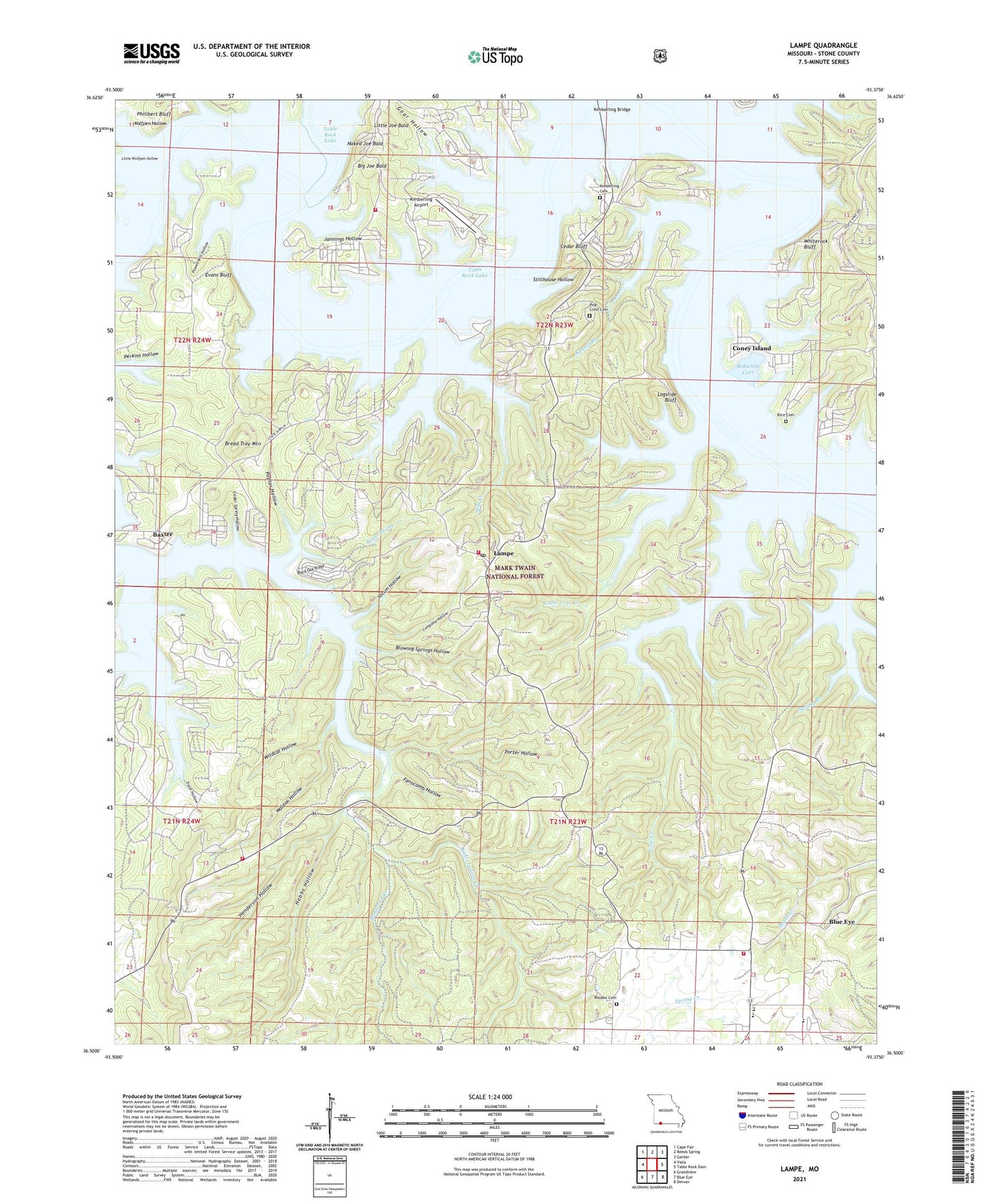
2021 topographic map quadrangle Lampe in the state of Missouri. Scale: 1:24000. Based on the newly updated USGS 7.5' US Topo map series, this map is in the following counties: Stone. The map contains contour data, water features, and other items you are used to seeing on USGS maps, but also has updated roads and other features. This is the next generation of topographic maps. Printed on high-quality waterproof paper with UV fade-resistant inks.
Quads adjacent to this one:
West: Viola
Northwest: Cape Fair
North: Reeds Spring
Northeast: Garber
East: Table Rock Dam
Southeast: Denver
South: Blue Eye
Southwest: Grandview
Contains the following named places: Baxter, Big Joe Bald, Black Oak Ridge, Blowing Springs Hollow, Blue Eye Public Schools, Blue Eye School, Bobwhite Cove, Bread Tray Mountain, Cedar Bluff, Cedar Spring Hollow, Company Hollow, Coney Island, Cow Creek, Cow Creek Park, Cow Creek Public Use Area, Dogwood Creek, Dorcas, Evans Bluff, Evans Cemetery, Fanncomb Hollow, Fisher Creek, Goar Hollow, Gospel Lighthouse Church, Great Bend of White River, Hammer Cemetery, Henderson Hollow, Highview Church, Hobbs Hollow, Homer, Hoot Owl Hollow, Horn Cemetery, Indian Hills Community Church, Jannings Hollow, Joe Bald Park, Jones School, Kanakuk-Kanakom Church Camp, Kennel Branch, Kimberling Airport, Kimberling Bridge, Kimberling Cemetery, Kimberling Park, Lampe, Little Cow Creek, Little Indian Creek, Little Joe Bald, Little Mill Creek, Little Wolfpen Hollow, Logslide Bluff, Marmaros, McCollough School, Mill Creek, Mill Creek Park, Mill Creek Public Use Area, Mobley Bluff, Naked Joe Bald, Old Elm Tree Church, Philibert Bluff, Philibert Cemetery, Pine Crest Cemetery, Pitts Cemetery, Poplar Hollow, Porter Hollow, Powell Mill Hollow, Radical, Rhodes Cemetery, Rice Cemetery, Right Prong, Schooner Creek, Slane Chapel, Slane School, Southern Stone County Fire Protection District Station 14, Southern Stone County Fire Protection District Station 15, Southern Stone County Fire Protection District Station 3, Southern Stone County Fire Protection District Station 4, Stillhouse Hollow, Sunrise School, Table Rock Lake, Thomas Camp, Thomas Cemetery, Tibbetts School, Town of Blue Eye, Township of Pine A, Township of Pine B, Trace Hollow, Village of Coney Island, Waldon Hollow, Whiterock Bluff, Whites Branch, Wildcat Hollow, Wolfpen Hollow, Yates Cemetery, Yocum Hollow, ZIP Code: 65681