MyTopo
Poplar Bluff Missouri US Topo Map
Couldn't load pickup availability
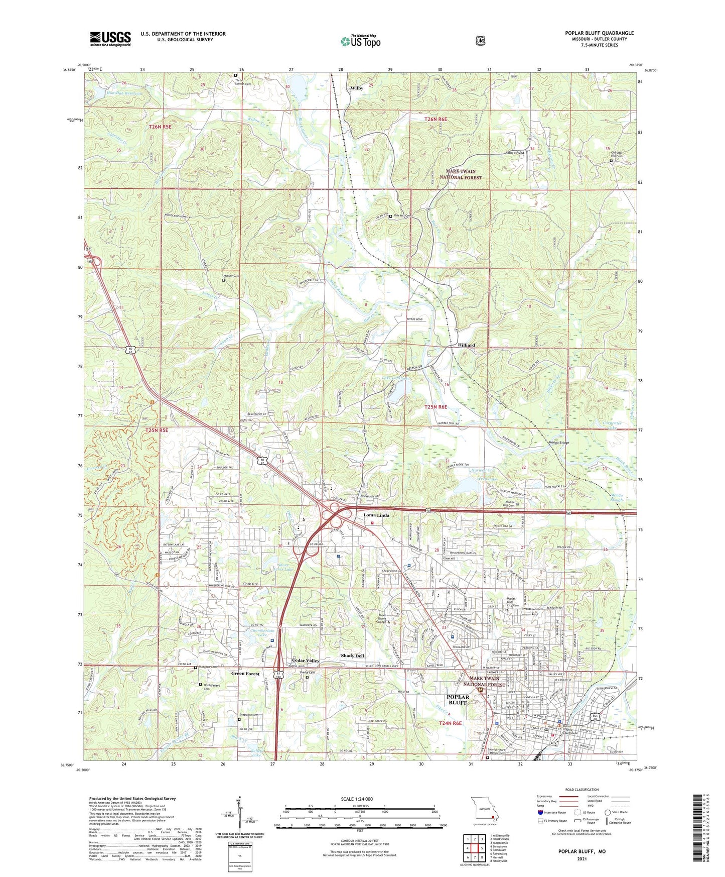
2021 topographic map quadrangle Poplar Bluff in the state of Missouri. Scale: 1:24000. Based on the newly updated USGS 7.5' US Topo map series, this map is in the following counties: Butler. The map contains contour data, water features, and other items you are used to seeing on USGS maps, but also has updated roads and other features. This is the next generation of topographic maps. Printed on high-quality waterproof paper with UV fade-resistant inks.
Quads adjacent to this one:
West: Stringtown
Northwest: Williamsville
North: Hendrickson
Northeast: Wappapello
East: Rombauer
Southeast: Hanleyville
South: Harviell
Southwest: Fairdealing
Contains the following named places: Agee Church, Agee Creek, Aldridge Creek, Bacon Memorial Park, Big Lake, Black Creek School, Black River Seminary, Buck Creek, Butler County Fire Protection District Oakbrier Station, Butler County Fire Protection District PP Highway Station, Butler County Sheriff's Office, Carpenter Lake, Cedar Valley, Chamberlain Dam, Chamberlain Lake, City of Poplar Bluff, Dobbs Creek, First Baptist Church, Green Forest, Green Forest Church, Hartman Creek, Harwell Creek, Hewlett Lake Dam, Hickory Creek, Hillcrest Park, Hilliard, Hoedapp Creek, Hon-Dah Reservoir, Hudgens Cemetery, Indian Creek, John J Pershing Veterans Affairs Medical Center, Kelley Lake, Kelley Lake Dam, Kelly Town, Kinyon School, KOKS-FM (Poplar Bluff), KPOB-TV (Poplar Bluff), KWOC-FM (Poplar Bluff), KXOQ-FM (Poplar Bluff), Lake Lockloma, Lake Lockloma Dam, Lake Shore Acres Dam, Lewis Creek, Line Park, Loma Linda, Lucy Lee Hospital Heliport, Mansion Mall, Marble Hill Cemetery, Marble Hill School, Mark Twain National Forest Poplar Bluff, Mark Twain School, Martin School, Mason Memorial Dam, Mengo, Mengo Bridge, Mengo Slough, Mill Creek, Missouri Department of Conservation Forestry Southeast Regional Field Fire Office Poplar Bluff, Missouri State Highway Patrol Troop E, Mononame 646 Dam, Mononame 667 Dam, Montgomery Cemetery, Mount Olive Church, North Side Church, Nunley Cemetery, Oak Brier Estates Dam, Oak Grove Church, Oak Grove School, Oak Hill Cemetery, Oak Hill Church, Oak Hill School, Oak Lookout Tower, Old Mark Twain School, O'Neal School, Palmer Slough, Pike Creek Church, Poplar Bluff, Poplar Bluff Country Club, Poplar Bluff Fire Department Station 1, Poplar Bluff Fire Department Station 2, Poplar Bluff Police Department, Poplar Bluff Post Office, Poplar Bluff Regional Medical Center - Westwood, Poplar Bluff Regional Medical Center South, Rolling Hills Estates Lake, Rolling Hills Estates Lake Dam, Sacred Heart Catholic Cemetery, Sacred Heart Church, Sacred Heart School, Second Baptist Church, Shadle Cemetery, Shady Dell, Sheppard Cemetery, Shipman Ford, Shore Acres Lake, Smith School, Tamaro Oaks Dam, Temple Church, Three Springs Cemetery, Three Springs School, Township Line Church, Wheatley School, Widow Creek, Wilby, Woodlawn Cemetery, Wren Lake, Wren Lake Dam, Yarbro Field, ZIP Codes: 63901, 63902