MyTopo
Webster Groves Missouri US Topo Map
Couldn't load pickup availability
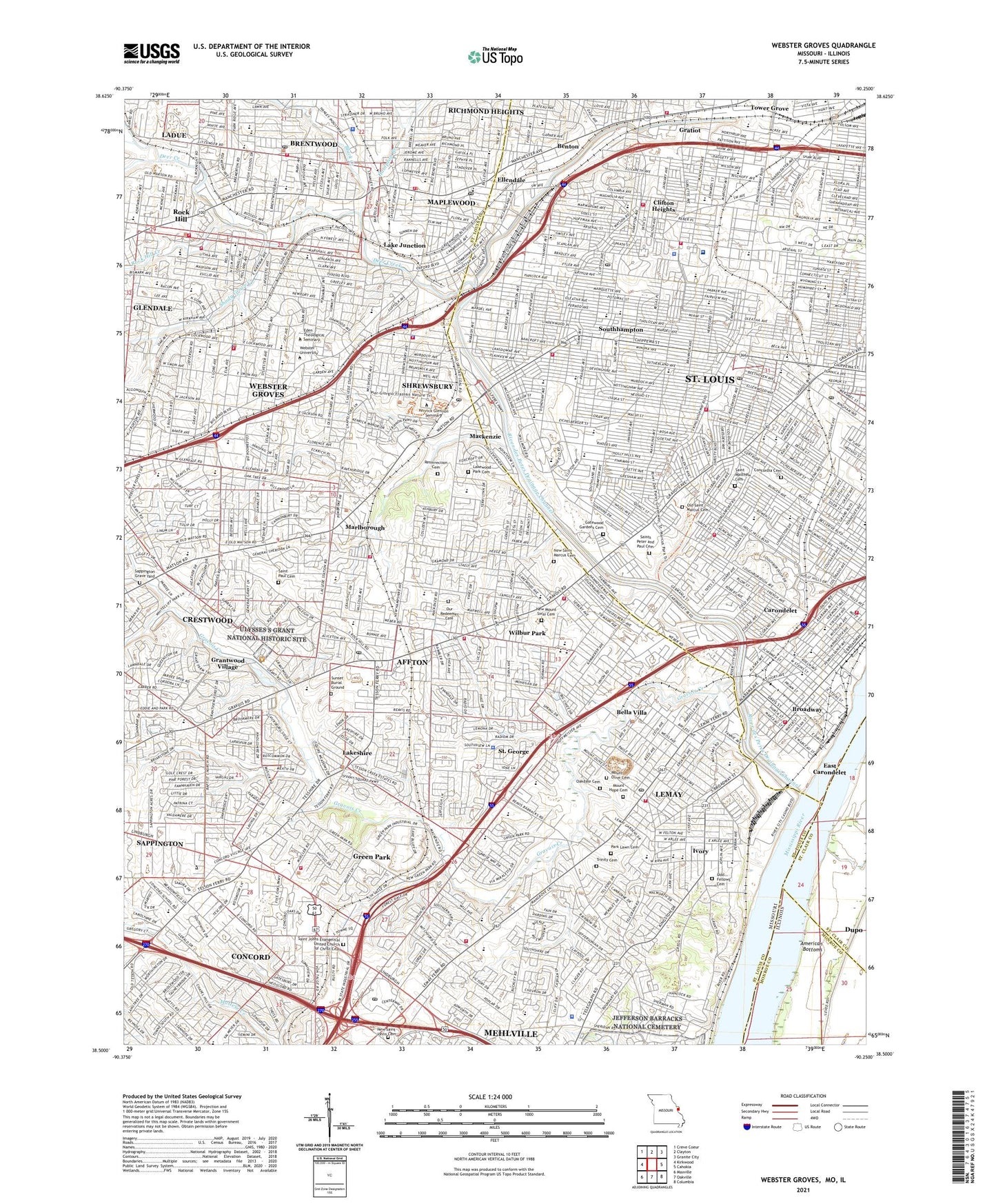
2021 topographic map quadrangle Webster Groves in the states of Missouri, Illinois. Scale: 1:24000. Based on the newly updated USGS 7.5' US Topo map series, this map is in the following counties: St. Louis, St. Louis (city), Monroe, St. Clair. The map contains contour data, water features, and other items you are used to seeing on USGS maps, but also has updated roads and other features. This is the next generation of topographic maps. Printed on high-quality waterproof paper with UV fade-resistant inks.
Quads adjacent to this one:
West: Kirkwood
Northwest: Creve Coeur
North: Clayton
Northeast: Granite City
East: Cahokia
Southeast: Columbia
South: Oakville
Southwest: Maxville
This map covers the same area as the classic USGS quad with code o38090e3.
Contains the following named places: Affton, Affton Census Designated Place, American Plaza Shopping Center, Assumption Parish School, Bayless School, Bella Villa, Benton, Bishop Dubourg High School, Black Creek, Black Forest County Park, Blackburn Park, Blow School, Bohrer County Park, Brentwood, Brentwood High School, Brentwood Plaza, Bristol Elementary School, Broadway, Buder School, Busch School, Carondelet, Carondelet Park, Carondelet School, Central City South, Central City South Shopping Center, Chippewa Plaza Shopping Center, Christy Park, City of Bella Villa, City of Brentwood, City of Green Park, City of Lakeshire, City of Maplewood, City of Rock Hill, City of Saint George, City of Shrewsbury, City of Webster Groves, Clark School, Claytonia Creek, Clifton Heights, Clifton Park, Clydesdale County Park, Colonial Square Shopping Center, Concord, Concord Census Designated Place, Concord Elementary School, Concord Plaza, Concordia Cemetery, Deer Creek, Deer Creek Center Shopping Center, Deer Creek Park, Douglass High School, Eden Theological Seminary, Edgar Road School, Edgebrook Station, Eighty-o-one Manchester Center, Ellendale, Francis Park, Franz Square, Frisco Park, Gardenville School, Gatewood Gardens Cemetery, General Grant Shopping Center, Goodal School, Grants, Grants Farm, Grantwood, Grantwood Village, Grasso Plaza, Gratiot, Gratiots League Square, Gravois Creek, Gravois Plaza Shopping Center, Green Park, Hampton Branch, Hampton Village Shopping Center, Hamsher High School, Hillside Village Shopping Center, Holy Family School, Ivory, Jefferson Barracks, Jefferson Barracks County Park, KDNL-TV (St Louis), Kendrick Plaza Shopping Center, Kennard School, Kenrick Seminary, KEZK-FM (St Louis), KFUO-FM (Clayton), KHTR-FM (St Louis), Kings Highway Shopping Center, KMJM-FM (St Louis), KMOV-TV (St Louis), KOMR-FM (St Louis), KPLR-TV (St Louis), KRJY-FM (St Louis), KSD-FM (Saint Louis), KSDK-TV (St Louis), KSHE-FM (Crestwood), KSIV-AM (Clayton), KTVI-TV (St Louis), KWMU-FM (St Louis), KYKY-FM (St Louis), Lake Junction, Lakeshire, Lakewood Park Cemetery, Lemay, Lemay Census Designated Place, Lindbergh Plaza Shopping Center, Lindenwood Park, Lindenwood School, Lockwood School, Long School, Longfellow School, Loughborough Shopping Center, Lyon School, Mackenzie, MacKenzie Point Shopping Center, Mann School, Maple Hills Shopping Center, Maplewood, Marion Heights Plaza, Mark Twain School, Marlborough, Marshalls Plaza Shopping Center, Mason School, Mehlville, Mehlville Census Designated Place, Mehlville High School, Missouri Botanical Garden, Mount Calvary School, Mount Hope Cemetery, Mount Olive Cemetery, Mount Saint Rose Hospital, MRH Early Childhood Center, MRH Elementary School, MRH Middle School, Mullanphy School, New Mount Sinai Cemetery, New Saint Johns Cemetery, New Saint Marcus Cemetery, Nottingham School, Oak Hill Elementary School, Oak Hill School, Oakdale Cemetery, Odd Fellows Cemetery, Ohlendorf County Park, Old Prairie duPont Creek, Old Saint Marcus Cemetery, Our Redeemer Cemetery, Park Lawn Cemetery, Peace School, R-9 County Park, Reavis School, Resurrection Cemetery, Richmond High School, Ritz Center, River des Peres, River des Peres Drainage Channel, Robert H Sperreng Middle School, Rock Hill Creek, Roe School, Rogers Middle School, Ronnies Plaza, Saint Andrew School, Saint Gabriels School, Saint George, Saint George Census Designated Place, Saint Joan of Arc Catholic School, Saint Johns Evangelical United Church of Christ Cemetery, Saint Josephs Convent of Mercy, Saint Louis Developmental Disabilities Treatment Center, Saint Louis Marketplace Shopping Center, Saint Louis Preparatory Seminary, Saint Louis Psychiatric Rehabilitation Medical Center, Saint Marys School, Saint Matthew Cemetery, Saint Michaels School, Saint Paul Cemetery, Saints Peter and Paul Cemetery, Sappington Census Designated Place, Sappington Grave Yard, Shady Grove Creek, Shaw School, Shrewsbury, South County Center, South County Habilitation Center, South County Plaza Shopping Center, South Lakeview Plaza, South Oaks Plaza Shopping Center, South Towne Plaza Shopping Center, Southhampton, Southtown Centre Shopping Center, Southwest High School, Stouffers Heliport, Sublette Park, Sunset Burial Ground, Sylvan Springs County Park, The Hill, Tilles Park, Tower Grove, Tower Grove Park, Town of Grantwood Village, Township of Concord, Township of Gravois, Township of Jefferson, Township of Lemay, Trinity Cemetery, Twomile Creek, Ulysses S Grant National Historic Site, Union Plaza, Union Road County Park, Valley School, Vigo Park, Village of Mackenzie, Village of Marlborough, Village of Wilbur Park, Washington Park School, Webster Groves, Webster University, Westfield Shoppingtown of South County Shopping Center, Wilbur Park, Wilkinson School, Willmore Park, Windsor School, WKBQ-FM (Granite City), Woerner School, Yorkshire Village Shopping Center, ZIP Codes: 63109, 63111, 63116, 63119, 63123, 63125, 63139, 63143, 63144