MyTopo
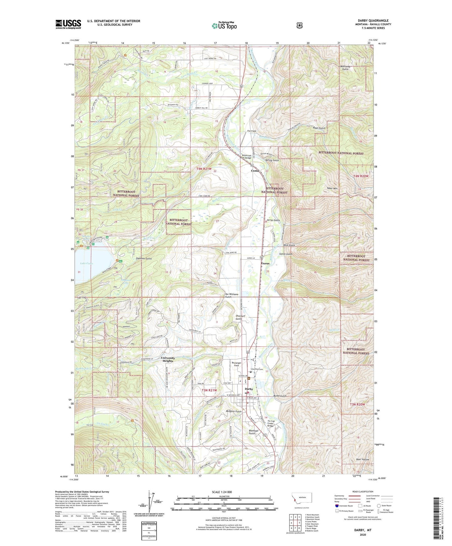
Darby Montana US Topo Map
Couldn't load pickup availability
Also explore the Darby Forest Service Topo of this same quad for updated USFS data
2024 topographic map quadrangle Darby in the state of Montana. Scale: 1:24000. Based on the newly updated USGS 7.5' US Topo map series, this map is in the following counties: Ravalli. The map contains contour data, water features, and other items you are used to seeing on USGS maps, but also has updated roads and other features. This is the next generation of topographic maps. Printed on high-quality waterproof paper with UV fade-resistant inks.
Quads adjacent to this one:
West: Como Peaks
Northwest: Ward Mountain
North: Hamilton South
Northeast: Mountain House
East: Deer Mountain
Southeast: Robbins Gulch
South: Burnt Ridge
Southwest: Trapper Peak
This map covers the same area as the classic USGS quad with code o46114a2.
Contains the following named places: 03N21W10DADD01 Well, 03N21W14BBDA01 Well, 03N21W14CAAA01 Well, 03N21W15CCCD01 Well, 03N21W22BDA_01 Well, 04N21W14CBAD01 Well, 04N21W16DDDD01 Well, 04N21W17BCBB01 Well, 04N21W28DDDD01 Well, 04N21W30DCDD01 Well, 04N21W32BDAA01 Well, 04N21W33AADA01 Well, 04N21W35CCBA01 Well, Bean, Bike Hostel Recreation Site, Bitterroot River Bridge, Blacktail Gulch, Boulanger Field, Bunkhouse Creek, Burke Gulch, Clear Creek, Community Christian School, Como, Como Lake Dam, Como Post Office, Como School, Darby, Darby Ambulance, Darby Division, Darby Elementary School, Darby High School, Darby Park, Darby Police Department, Darby Post Office, Darby Public Library, Darby Volunteer Fire Department, Dick Gulch, Durland Park Campground, Family Fellowship Church, Fern Creek, First Baptist Church, Fox Field, Gorus, Gorus Gulch, Harlan Creek, Historic Forest Service Museum, Holtet Court, Ike Williams Gulch, Jerrys Gulch, Kramis Pond, Lake Como Campground, Lick Creek, Lick Creek Campground, Lone Pine Cemetery, Lost Horse Creek, McCarty Creek, McQuirk Gulch, Mike Creek, Mister Ts Wildlife Museum, Moose Creek, Overturf Gulch, Pioneer Museum, Roan Gulch, Rock Creek, Rock Creek Horse Camp, Rock Creek Trailhead, Saint Philip Benizi Mission, Shannon Gulch, Shannon Lake, Southwick Creek, Spring Gulch, Stella Creek, Tabor Mountain, The Church of Jesus Christ of Latter Day Saints, Tin Cup Creek, Tin Cup Creek Bridge, Town of Darby, University Heights, Upper Como Campground, Waddell Creek, Wallace Crawford Memorial Fishing Access Site