MyTopo
Fairview Montana US Topo Map
Couldn't load pickup availability
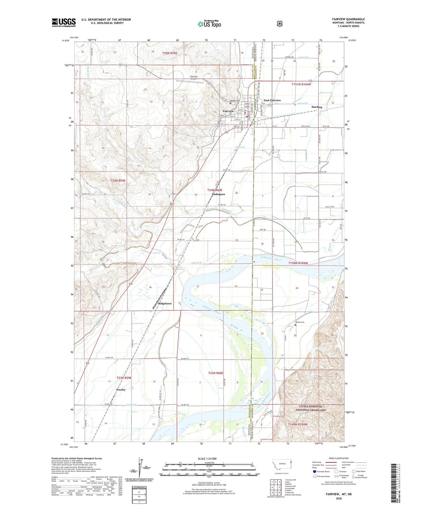
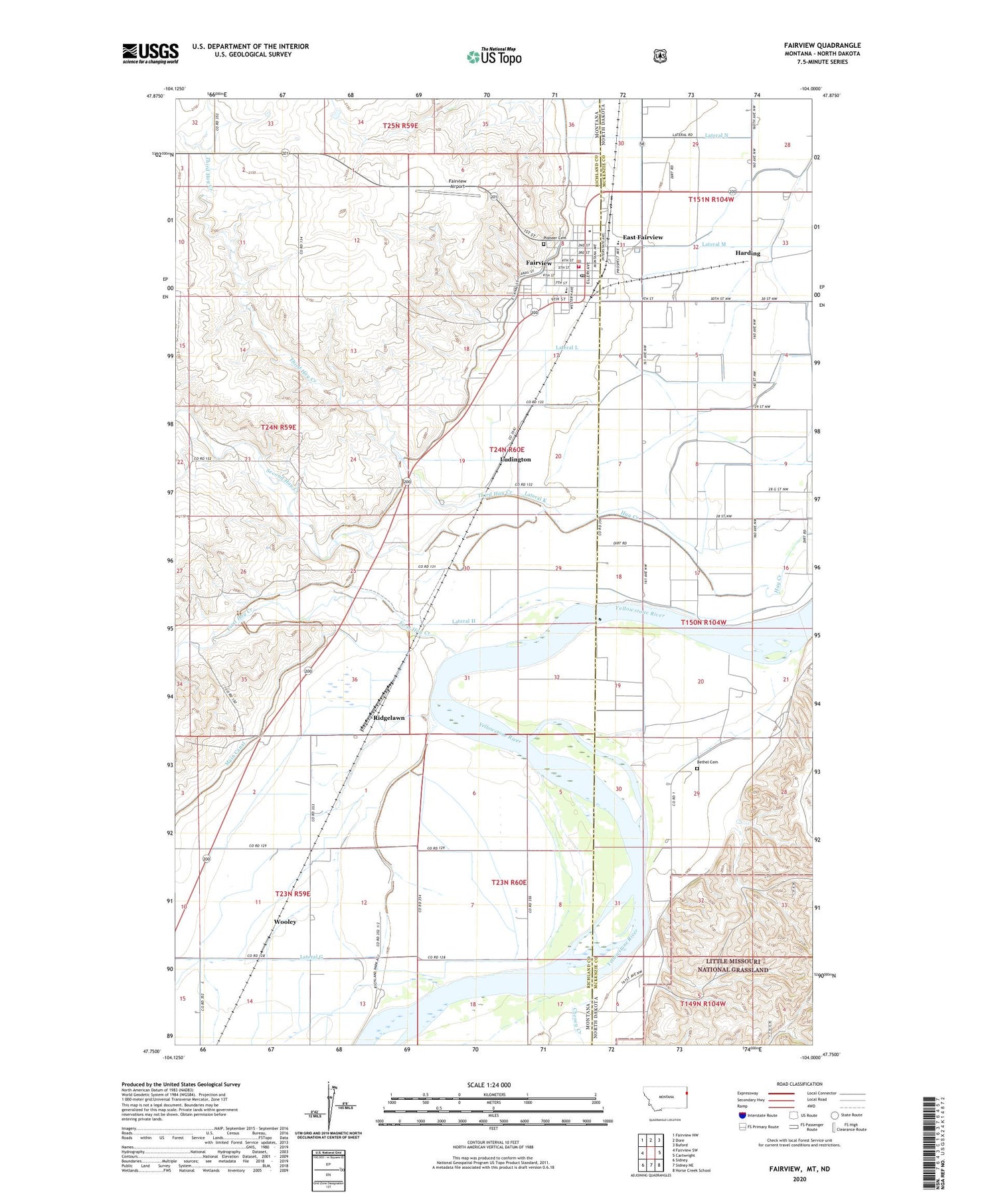
2020 topographic map quadrangle Fairview in the states of Montana, North Dakota. Scale: 1:24000. Based on the newly updated USGS 7.5' US Topo map series, this map is in the following counties: Richland, McKenzie. The map contains contour data, water features, and other items you are used to seeing on USGS maps, but also has updated roads and other features. This is the next generation of topographic maps. Printed on high-quality waterproof paper with UV fade-resistant inks.
Quads adjacent to this one:
West: Fairview SW
Northwest: Fairview NW
North: Dore
Northeast: Buford
East: Cartwright
Southeast: Horse Creek School
South: Sidney NE
Southwest: Sidney
Contains the following named places: 23N59E01AB__01 Well, 23N59E01BA__01 Well, 23N59E01BC__01 Well, 23N59E01CC__01 Well, 23N59E01DC__01 Well, 23N59E02AB__01 Well, 23N59E02CA__01 Well, 23N59E02CC__01 Well, 23N59E02DB__01 Well, 23N59E02DD__01 Well, 23N59E02DD__02 Well, 23N59E11AA__01 Well, 23N59E11AA__02 Well, 23N59E11AB__01 Well, 23N59E11BA__01 Well, 23N59E11BA__02 Well, 23N59E11CC__01 Well, 23N59E11CD__01 Well, 23N59E12AC__01 Well, 23N59E12DA__01 Well, 23N59E12DA__02 Well, 23N59E13AA__01 Well, 23N59E13BA__01 Well, 23N59E13BC__01 Well, 23N59E14AA__01 Well, 23N59E14AB__01 Well, 23N59E14DA__01 Well, 23N60E06CA__01 Well, 23N60E06CD__01 Well, 23N60E06DC__01 Well, 23N60E07AD__01 Well, 23N60E07CD__01 Well, 23N60E08BC__01 Well, 23N60E18AA__01 Well, 23N60E18BB__01 Well, 24N59E03DDDD01 Well, 24N60E07BA__01 Well, 24N60E18AACA01 Well, 24N60E19BAC_01 Well, Bethel Cemetery, Brodhead Maternity Home, Cheney, Cheney Creek, Community Presbyterian Church, Diamond Willow Fishing Access Site, East Fairview, East Fairview Census Designated Place, East Fairview Elementary School, Estes School, Fairview, Fairview Airport, Fairview Alliance Church, Fairview Bean and Seed Elevator, Fairview Police Department, Fairview Post Office, Fairview School, Fairview Volunteer Fire Department, First Hay Creek, First Presbyterian Church, Fort Gilbert, H Pederson Ranch, Harding, KGCX-AM (Sidney), Lateral G, Lateral H, Lateral K, Lateral L, Lateral M, Lateral N, Lewis and Clark Trail, Ludington, M Flynn Ranch, Mondak Family Clinic, Nineteen hundred and three Lateral N, Old Fort Gilbert Historical Marker, Pioneer Cemetery, R Olson Ranch, Richland County Ambulance Fairview, Richland Park, Ridgelawn, Ridgelawn Post Office, Ridgelawn School, Roughrider Grain Company Elevator, Saint Catherine Catholic Church, Saint Johns Lutheran Church Missouri Synod, Second Hay Creek, Sharbano Park, Third Hay Creek, Town of Fairview, Wooley, Zion Lutheran Church