MyTopo
Florence Montana US Topo Map
Couldn't load pickup availability
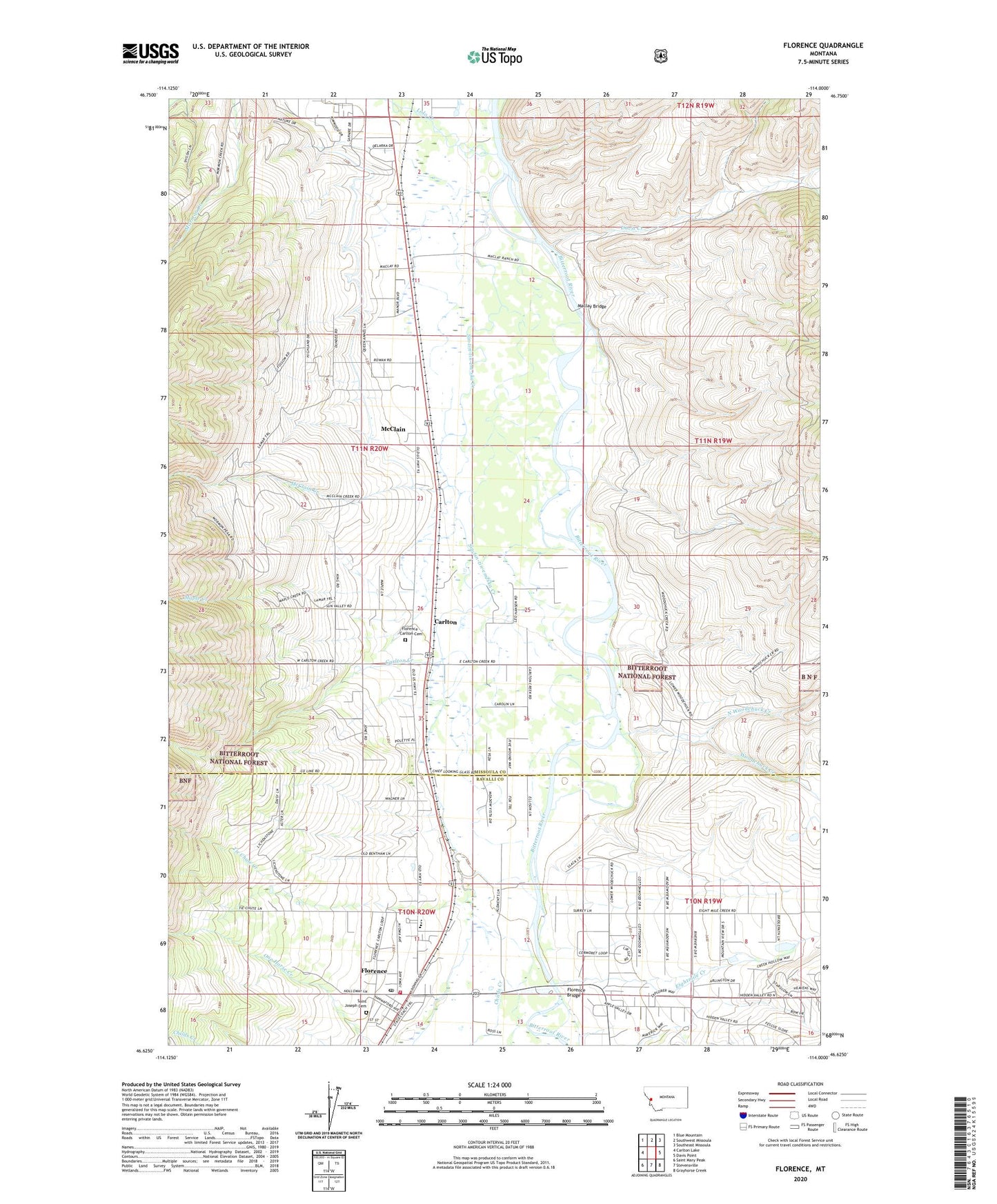
2020 topographic map quadrangle Florence in the state of Montana. Scale: 1:24000. Based on the newly updated USGS 7.5' US Topo map series, this map is in the following counties: Missoula, Ravalli. The map contains contour data, water features, and other items you are used to seeing on USGS maps, but also has updated roads and other features. This is the next generation of topographic maps. Printed on high-quality waterproof paper with UV fade-resistant inks.
Quads adjacent to this one:
West: Carlton Lake
Northwest: Blue Mountain
North: Southwest Missoula
Northeast: Southeast Missoula
East: Davis Point
Southeast: Grayhorse Creek
South: Stevensville
Southwest: Saint Mary Peak
Contains the following named places: 10N19W05DCDD01 Well, 10N19W06CDCB01 Well, 10N19W06CDDA01 Well, 10N19W06DCCC01 Well, 10N19W06DCDA01 Well, 10N19W06DDCC01 Well, 10N19W07AA__01 Well, 10N19W07ADBC01 Well, 10N19W07BAAD01 Well, 10N19W07BACB01 Well, 10N19W07BD__01 Well, 10N19W07BDAD01 Well, 10N19W07BDBB01 Well, 10N19W07CAAB01 Well, 10N19W07CABD01 Well, 10N19W07CACC01 Well, 10N19W07CD__01 Well, 10N19W07CD__02 Well, 10N19W07CDAA01 Well, 10N19W07CDBB01 Well, 10N19W07DBBC01 Well, 10N19W07DC__02 Well, 10N19W07DDCC01 Well, 10N19W07DDDC01 Well, 10N19W08ABBC01 Well, 10N19W08ADAD01 Well, 10N19W08ADDC01 Well, 10N19W08BABC01 Well, 10N19W08BADD01 Well, 10N19W08BBDD01 Well, 10N19W08BCBB01 Well, 10N19W08BCCC01 Well, 10N19W08BCDB01 Well, 10N19W08BDAB01 Well, 10N19W08BDBB01 Well, 10N19W08CBAA01 Well, 10N19W08CBDD01 Well, 10N19W08CDAC01 Well, 10N19W08DAAC01 Well, 10N19W08DCCC01 Well, 10N19W09BCCC01 Well, 10N19W16BBBC01 Well, 10N19W17BAAA01 Well, 10N19W17BBDA01 Well, 10N19W17BBDC01 Well, 10N19W18AAAA01 Well, 10N19W18BADB01 Well, 10N20W02ABBC01 Well, 10N20W10ACBC01 Well, 10N20W12ACDB01 Well, 10N20W12ADAA01 Well, 10N20W12ADDC01 Well, 10N20W12CC__01 Well, 10N20W12DAAA01 Well, 10N20W12DADA01 Well, 10N20W12DDDC01 Well, 10N20W13BBA_01 Well, 10N20W14BA__01 Well, 11N20W27DDBB01 Well, 12N19W32DDBD01 Well, 59833, Bitterroot Pines, Carlton, Carlton Census Designated Place, Carlton Creek, Carlton Post Office, Carlton School, Chief Looking Glass Campground, Chief Looking Glass Fishing Access Site, Childs Creek, Cooper, Davis Creek, Eightmile Creek, Florence, Florence - Carlton Cemetery, Florence Baptist Church, Florence Bridge, Florence Bridge Fishing Access Site, Florence Bridge North Fishing Access Site, Florence Bridge Recreation Site, Florence Census Designated Place, Florence Christian Academy, Florence Fire District - Station 1, Florence Post Office, Florence-Carlton Community Church, Florence-Carlton School, Keating, Lolo Creek, Lolo Peak Trailer Court, Maclay Bridge, Maple Creek, McClain, McClain Creek, North Woodchuck Creek, One Horse Creek, Rocks Trailer Court, Saint Joseph Cemetery, Saint Joseph Mission, Sin-tin-tin-em-ska Creek, Tie Chute Creek, Travelers Rest Historical Marker, Valley West Trailer Court, Woodchuck Creek