MyTopo
Helena Montana US Topo Map
Couldn't load pickup availability
Also explore the Helena Forest Service Topo of this same quad for updated USFS data
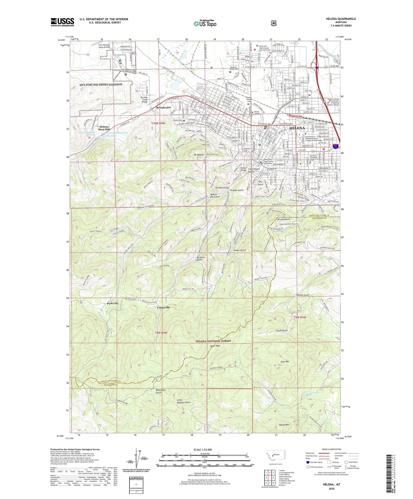
2024 topographic map quadrangle Helena in the state of Montana. Scale: 1:24000. Based on the newly updated USGS 7.5' US Topo map series, this map is in the following counties: Lewis and Clark, Jefferson. The map contains contour data, water features, and other items you are used to seeing on USGS maps, but also has updated roads and other features. This is the next generation of topographic maps. Printed on high-quality waterproof paper with UV fade-resistant inks.
Quads adjacent to this one:
West: Black Mountain
Northwest: Austin
North: Scratchgravel Hills
Northeast: Lake Helena
East: East Helena
Southeast: Clancy
South: Jefferson City
Southwest: Chessman Reservoir
This map covers the same area as the classic USGS quad with code o46112e1.
Contains the following named places: 09N03W17DBC_01 Well, 09N04W02DADB01 Well, 09N04W10CBBA01 Well, 09N04W11CCCB01 Well, 09N04W11CDBD01 Well, 09N04W11DCAD01 Well, 09N04W12CABB01 Well, 09N04W15BBBD01 Well, 09N04W16BACB01 Well, 10N03W17ACCC01 Well, 10N03W17ACCC02 Well, 10N03W17CCCC01 Well, 10N03W17DCDD01 Well, 10N03W18ACC_01 Well, 10N03W18ADDD01 Well, 10N03W18CACD01 Well, 10N03W18CCC_01 Well, 10N03W18CDD_01 Well, 10N03W18DDD_01 Well, 10N03W19ACC_01 Well, 10N03W19BCCC01 Well, 10N03W19BDDD01 Well, 10N03W19CCBB01 Well, 10N03W19CCDA01 Well, 10N03W20CAAC01 Well, 10N03W20CCAA01 Well, 10N03W27CCAB01 Well, 10N03W29BCAD01 Well, 10N03W30DAAD01 Well, 10N03W30DADA01 Well, 10N03W31BDBD01 Well, 10N03W31CBBD01 Well, 10N03W32BCBD01 Well, 10N04W13ACCD01 Well, 10N04W13ACCD02 Well, 10N04W13CBB_01 Well, 10N04W13DCAC01 Well, 10N04W13DCAD01 Well, 10N04W13DCAD02 Well, 10N04W13DCAD03 Well, 10N04W13DCBD01 Well, 10N04W13DCCA01 Well, 10N04W13DCCB01 Well, 10N04W13DCDA01 Well, 10N04W13DCDB01 Well, 10N04W13DCDB02 Well, 10N04W13DCDB03 Well, 10N04W13DCDC01 Well, 10N04W15CCCC01 Well, 10N04W15DBB_01 Well, 10N04W15DBBB01 Well, 10N04W16DDAA01 Well, 10N04W22ACAB01 Well, 10N04W22ACAB02 Well, 10N04W22ACAC01 Well, 10N04W22CDCA01 Well, 10N04W22DBAB01 Well, 10N04W23ABBC01 Well, 10N04W23BAAB01 Well, 10N04W23BAB_01 Well, 10N04W23BAC_02 Well, 10N04W23BBBB01 Well, 10N04W23BBCB01 Well, 10N04W23BBCB02 Well, 10N04W23CADD01 Well, 10N04W23DACD01 Well, 10N04W23DDDD01 Well, 10N04W24ADBC01 Well, 10N04W25ACDB01 Well, 10N04W25DBDC01 Well, 10N04W26AACB01 Well, 10N04W27BBBC01 Well, 10N04W27BBDA01 Well, 10N04W28AADC01 Well, 10N04W28ACAD01 Well, 10N04W28ACAD02 Well, 10N04W28ACDB01 Spring, 10N04W28ACDB02 Well, 10N04W28ACDB03 Well, 10N04W28ACDB04 Well, 10N04W28ACDB05 Spring, 10N04W28ACDB06 Spring, 10N04W28ACDB07 Well, 10N04W28ADDA01 Well, 10N04W33BBAB01 Well, 10N04W35CACC01 Well, 10N04W36DCBB01 Well, 1906 Trail, 59636, Arrastra Gulch, Arrastra Gulch Mine, Backside Trail, Barney Park, Batch Fields, Beattie Park, Benton Avenue Cemetery, Benton Avenue Cemetery Park, Bill Roberts Municipal Golf Course, Bluebird Mine, Boy With a Leaking Boot Statue, Branding Iron RV Park, Broadwater, Brooklyn Bridge Mine, Calvary Cemetery, Camp Robert B Smith, Capital Hill Mall, Centennial / Bausch Park, Cherry Hill Park, City of Helena, Civic Center Park, Clinton Park, Constitution Park, Crane Mine, Cunningham Park, Davis Gulch III Mine, Dotsonville, Dry Gas, Dry Gulch, Exchange Field, Fair Ground Junction, Family Health Clinic, Fire Tower Park, Fort William Henry Harrison, Golden Mine, Great Northern Crossing, Green Meadow Country Club, Grizzly Gulch, Helena, Helena Barracks, Helena Division, Helena Family Physicians Center, Helena Pediatric Clinic, Helena Ranger Station, Helena Valley Womens Clinic, Helena West Side Census Designated Place, Heritage / Pioneer Park, Hill Park, Hogback Trail, Home of Peace Cemetery, Hotel Broadwater, Humboldt Mine, Hustad Center, Jack Mountain, KBLL-AM (Helena), KCAP-AM (Helena), Kenwood, Kessler Park, Kindrick Legion Field, Lange, Last Chance Gulch, Last Chance Gulch Historical Marker, Last Chance Mall Park, Lewis and Clark Camp Hospital, Lewis and Clark County Fairgrounds, Lewis and Clark County Poor Farm Cemetery, Lincoln Park, Lockey Park, Looby Mine, Lundy Center, Mares, McHugh Trailer Court, Memorial Park, Mobile City Home Park, Montana State Nursery, Montana State Veterans Cemetery, Montana Veterans Affairs Health Care System - Fort Harrison, Morelli Bridge, Mount Ascension, Mount Ascension Park, Mount Helena, Mount Helena City Park, Mount Helena National Recreation Trail, NE NE Section 16 Mine, NE NE Section 9 Mine, NE NW Section 10 Mine, NE NW Section 11 Mine, NE NW Section 12 Mine, NE SW Section 36 Mine, None Such/Jumbo Mine, North Access Trail, Northgate Plaza, Northwest Park, Noyau Mine, NW NE Section 29 Mine, NW NW Section 17 Mine, NW NW Section 29 Mine, NW SW Section 4 Mine, Oro Y Plata Mine, Orofino Gulch, Pardis Chiropractic Clinic, Park City, Pocha Park, Prairie Trail, Prospect Shafts Trail, Ramey Park, Reeders Alley, Reeders Alley Park, Reynolds Trailer Court, Rimini Junction, Robinson Park, Ryan Park, SE SW Section 9 Mine, Sheep Mountain, Sixth Ward Park, Skihi Peak, Smallwood Mine, Spring Hill Tailings, Spring Meadow Lake State Park, Spring Meadow Park, Springtown, Squaw Gulch II Mine, Squaw Gulch Mine, State Capitol Grounds, Steadman, Sterling Price Mine, Stewart Homes Park, SW NW Section 10 Mine, SW NW Section 11 Mine, SW SE Section 12 Mine, SW SE Section 22 Mine, SW SW Section 11 Mine, Ten Mile Creek Bridge, The Bullwhacker Statue, The Prospectors Sculpture and Fountain, Thermal Springs, Thomas Francis Meagher Statue, Tucker Gulch, Twilight Mine, Unionville, Unionville Census Designated Place, Veterans Administration Center, Wakina Sky Gulch, Waukesha Park, Wesleyan Park, Womens Park