MyTopo
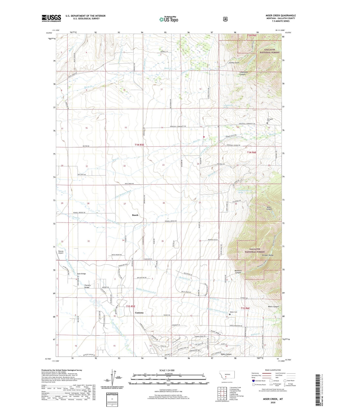
Miser Creek Montana US Topo Map
Couldn't load pickup availability
Also explore the Miser Creek Forest Service Topo of this same quad for updated USFS data
2024 topographic map quadrangle Miser Creek in the state of Montana. Scale: 1:24000. Based on the newly updated USGS 7.5' US Topo map series, this map is in the following counties: Gallatin. The map contains contour data, water features, and other items you are used to seeing on USGS maps, but also has updated roads and other features. This is the next generation of topographic maps. Printed on high-quality waterproof paper with UV fade-resistant inks.
Quads adjacent to this one:
West: Belgrade
Northwest: Horseshoe Creek
North: Flathead Pass
Northeast: Sacagawea Peak
East: Saddle Peak
Southeast: Kelly Creek
South: Bozeman
Southwest: Bozeman Hot Springs
This map covers the same area as the classic USGS quad with code o45111g1.
Contains the following named places: 01N03E10BB__01 Well, 01N05E02AAAC01 Well, 01N05E02BAAD01 Well, 01N05E03DA__01 Well, 01N05E04DD__01 Well, 01N05E04DD__02 Well, 01N05E04DDAD01 Well, 01N05E04DDAD02 Well, 01N05E05DA__01 Well, 01N05E08AD__01 Well, 01N05E09BB__01 Well, 01N05E10BA__01 Well, 01N05E11CB__01 Well, 01N05E11CB__02 Well, 01N05E13AD__01 Well, 01N05E14AB__01 Well, 01N05E14ACDD01 Well, 01N05E15CB__01 Well, 01N05E15CB__02 Well, 01N05E16BC__01 Well, 01N05E16DAAA01 Well, 01N05E20DBAA01 Well, 01N05E21BC__01 Well, 01N05E21BC__02 Well, 01N05E21BC__03 Well, 01N05E21BC__04 Well, 01N05E21CA__01 Well, 01N05E22AD__01 Well, 01N05E22CC__01 Well, 01N05E23CC__01 Well, 01N05E24AC__01 Well, 01N05E26CD__01 Well, 01N05E27CC__01 Well, 01N05E28DB__01 Well, 01N05E28DB__02 Well, 01N05E28DCAD01 Well, 01N05E32DD__01 Well, 01N05E34BD__01 Well, 01N05E34BD__02 Well, 01N05E34DB__01 Well, 01N05E34DDDC01 Well, 01N05E35AA__01 Well, 01N05E35AD__01 Well, 01N05E35ADBB01 Well, 01N05E35CA__01 Well, 01N05E36CD__01 Well, 01N06E07CC__01 Spring, 01N06E17CDCB01 Well, 01N06E18CB__01 Well, 01N06E18CB__02 Well, 01N06E30AB__01 Spring, 01N06E30BCBB01 Well, 01S05E01CB__01 Well, 01S05E02DC__01 Well, 01S05E03CB__01 Well, 01S05E03CD__01 Well, 01S05E04BD__01 Well, 01S05E04DB__01 Well, 01S05E04DC__01 Well, 01S05E04DC__02 Well, 01S05E09AC__01 Well, 01S05E09ACCC01 Well, 01S05E09BB__01 Well, 01S05E09DCCC01 Well, 01S05E10AC__01 Well, 01S05E10CC__01 Well, 01S05E11BC__01 Well, 01S05E11CB__01 Well, 01S05E12AD__01 Well, 01S05E12BCCC01 Well, 01S05E12BCCC02 Well, 01S05E12DB__01 Well, 01S05E13AA__01 Well, 01S05E14BD__01 Well, 01S05E15BA__01 Well, 01S05E15BCBA01 Well, 01S06E06ABCB01 Well, 01S06E18BBBB01 Well, Bill Smith Creek, Bostwick Canyon, Bostwick Creek, Bueno Vista Acres Trailer Court, Busch, Camona, Corbly Gulch, Courts Post Office, Decker School, East Gallatin Post Office, East Gallatin School, Flannery Bridge, Jones Creek, Limestone Canyon, Limestone Creek, Lutz McGuire Ditch, Middle Cottonwood Creek, Miser Canyon, Miser Creek, North Cottonwood Creek, Penwellton, Reese Creek, Schafer Creek, Sexton Post Office, Spain, Spain Bridge, Spring Branch, Springhill, Springhill Cemetery, Springhill Church, Springhill Fire - Central Valley Fire Disctrict, Springhill Post Office, Springhill School, Thomasville, Walker, Walker Cemetery, Walker School, Walton Creek, Watts Canyon, Wisner, Wisner Crossing