
MyTopo
Nye Montana US Topo Map
Couldn't load pickup availability
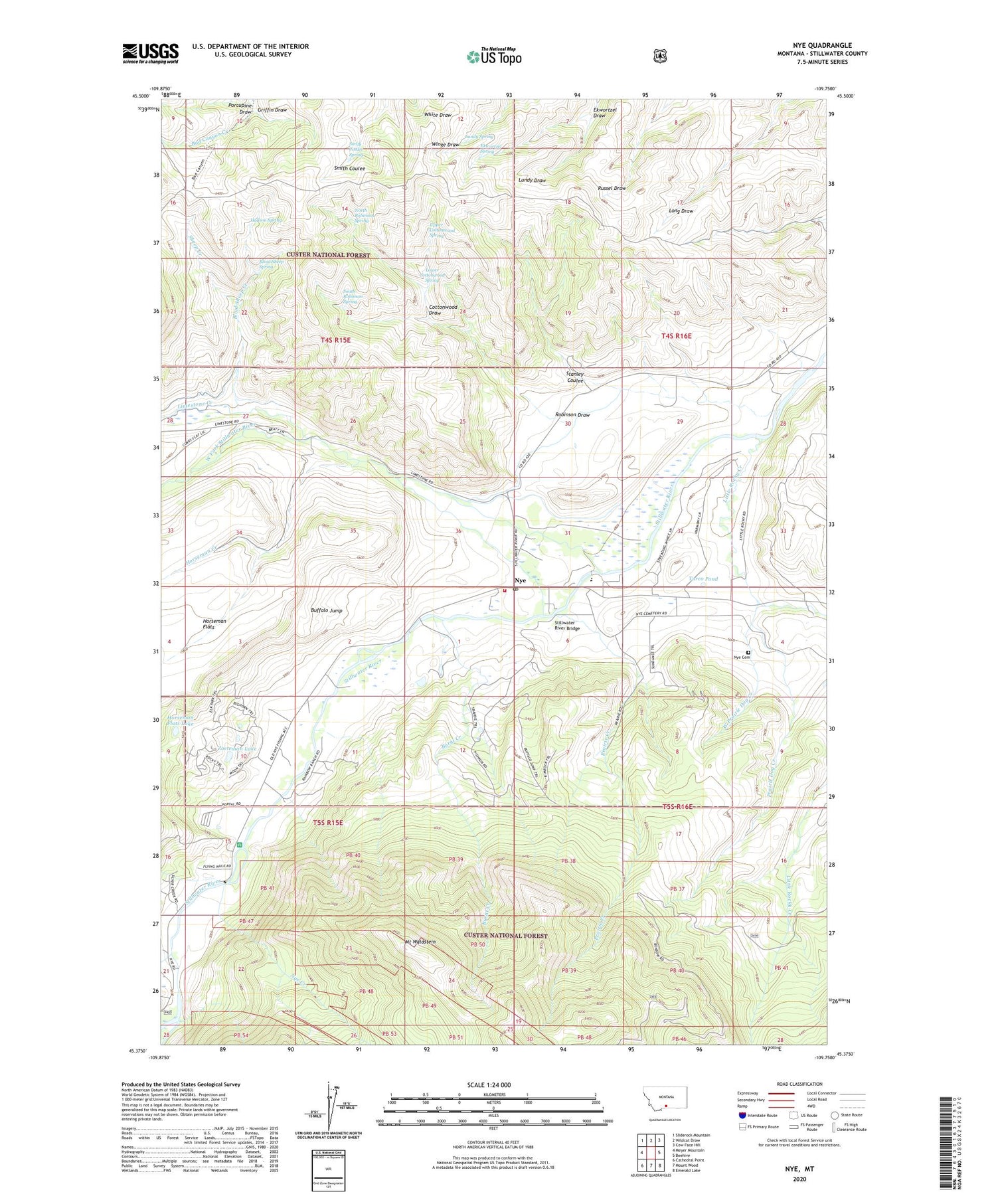
2020 topographic map quadrangle Nye in the state of Montana. Scale: 1:24000. Based on the newly updated USGS 7.5' US Topo map series, this map is in the following counties: Stillwater. The map contains contour data, water features, and other items you are used to seeing on USGS maps, but also has updated roads and other features. This is the next generation of topographic maps. Printed on high-quality waterproof paper with UV fade-resistant inks.
Quads adjacent to this one:
West: Meyer Mountain
Northwest: Sliderock Mountain
North: Wildcat Draw
Northeast: Cow Face Hill
East: Beehive
Southeast: Emerald Lake
South: Mount Wood
Southwest: Cathedral Point
Contains the following named places: 04S15E25AABA01 Well, 04S15E27DAAC01 Well, 04S15E34DCAC01 Spring, 04S16E28BADB01 Well, 04S16E29BADA01 Well, 04S16E29BADA02 Well, 04S16E29BADA03 Well, 04S16E29BBAC01 Well, 04S16E29BCDA01 Well, 04S16E30BDCD01 Well, 04S16E30CCDD01 Well, 04S16E30DBDB01 Well, 04S16E31DDDB01 Well, 05S15E01AAAA01 Well, 05S15E02AABA01 Spring, 05S15E02ACDB01 Spring, 05S15E02BBAC01 Spring, 05S15E02DCCB01 Well, 05S15E10DADA01 Well, 05S15E15CACD01 Well, 05S15E15CCBB01 Well, 05S15E21AADD01 Well, 05S15E21ADDD01 Well, 05S15E22BBBB01 Well, 05S16E06BAAB01 Well, Absarokee Division, Benbow Millsite, Blind Sheep Creek, Blind Sheep Spring, Buffalo Jump, Buffalo Jump Fishing Access Site, Buffalo Jump Recreation Site, Burnt Creek, Cottonwood Draw, Ekwortzel Draw, Ekwortzel Spring, Griffin Draw, Horseman Creek, Horseman Flats Lake, Hudson Spring, Limestone Creek, Little Rocky Creek, Lower Cottonwood Spring, Lundy Spring, Magpie Creek, Moraine Fishing Access Site, Mount Waldstein, North Robinson Spring, Nye, Nye Cemetery, Nye Census Designated Place, Nye Community Church, Nye Creek, Nye Post Office, Nye School, Nye Volunteer Fire Company, Porcupine Draw, Prairie Creek, Prairie Dog Creek, Robinson Draw, Sheep Creek, Smith Coulee Spring, South Robinson Spring, Stanley Coulee, Stillwater River Bridge, Tandy 6 Coal Mine, Turco Pond, Upper Cottonwood Spring, West Fork Stillwater River, West Prairie Dog Creek, Zoeteman Lake


