MyTopo
Southeast Missoula Montana US Topo Map
Couldn't load pickup availability
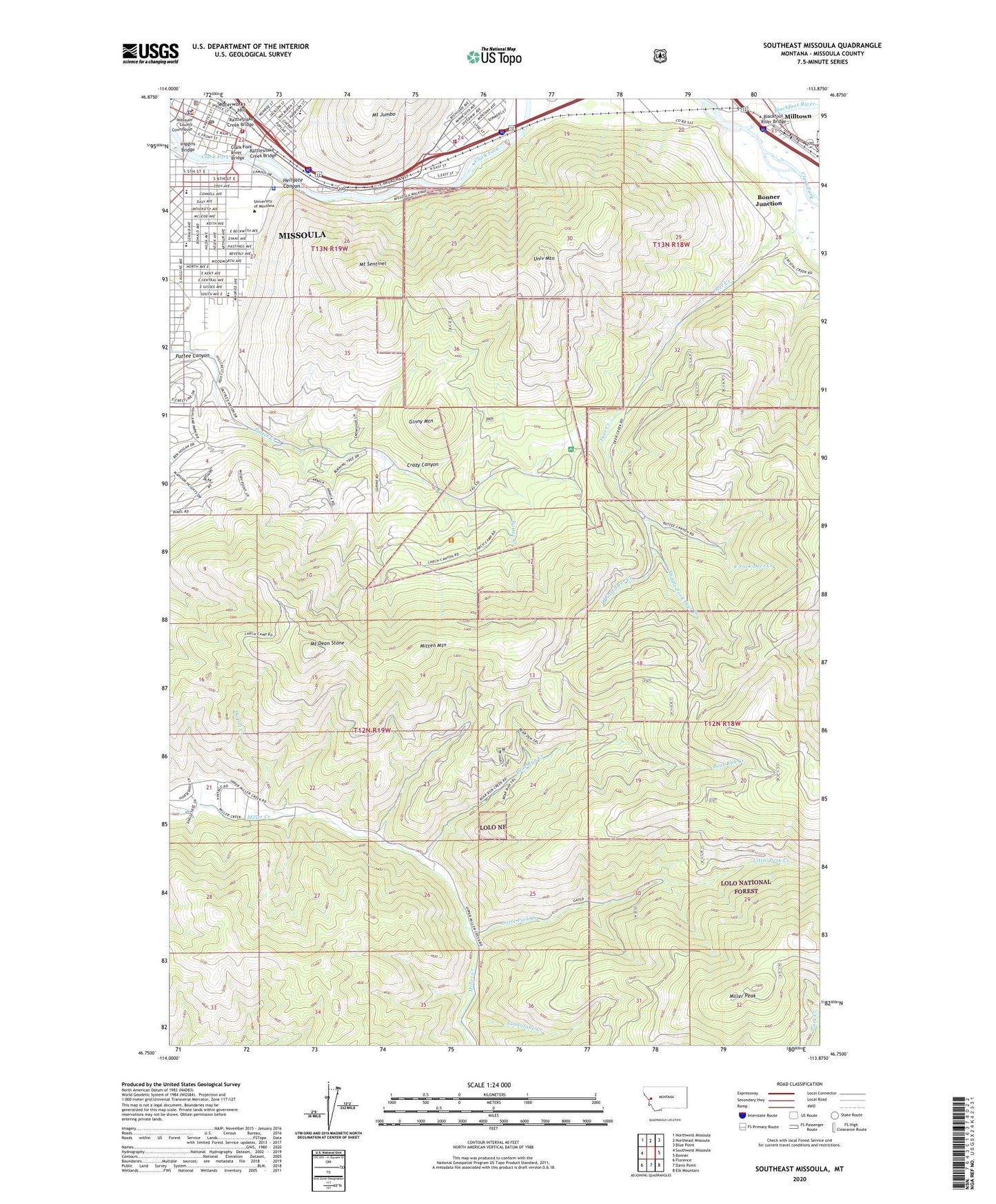
2020 topographic map quadrangle Southeast Missoula in the state of Montana. Scale: 1:24000. Based on the newly updated USGS 7.5' US Topo map series, this map is in the following counties: Missoula. The map contains contour data, water features, and other items you are used to seeing on USGS maps, but also has updated roads and other features. This is the next generation of topographic maps. Printed on high-quality waterproof paper with UV fade-resistant inks.
Quads adjacent to this one:
West: Southwest Missoula
Northwest: Northwest Missoula
North: Northeast Missoula
Northeast: Blue Point
East: Bonner
Southeast: Elk Mountain
South: Davis Point
Southwest: Florence
Contains the following named places: 13N19W21AD__01 Well, 13N19W21AD__02 Well, 13N19W22BC__01 Well, 13N19W22BC__02 Well, 13N19W22BC__03 Well, 13N19W22CB__01 Well, 13N19W22CB__02 Well, 13N19W22DB__01 Well, 13N19W22DB__02 Well, 13N19W24CD__01 Well, 13N19W27ACBC01 Well, 13N19W27BC__01 Well, 13N19W27CCAD01 Well, 13N19W33AD__01 Well, 13N19W34BB__01 Well, 59803, 59851, Aber Hall, Anderson Chiropractic Clinic, Anderson Park, Art Annex, Bear Run Creek, Bess Reed Park, Blackfoot River, Blackfoot River Bridge, Bonner Junction, Bonner Park, Botany Building, Brantly Hall, Burlington Northern Plaza, Business Administration Building, Buzan Chiropractic Clinic, Calvary Chapel, Campbell Park, Cantonment Wright, Caras Park, Center for Continuing Education, Central School, Chemistry-Pharmacy Building, Christ the King Church, Church of Christ, Church of the Holy Spirit, Clark Fork Christian Center, Clark Fork River Bridge, Clinical Psychology Center, Clover Bowl, Community Medical Center Heliport, Corbett Chiropractic Clinic, Corbin Hall, Craig Hall, Crazy Canyon, Dagret Creek, Deer Creek, Dornblaser Track, Duniway Hall, East Fork Deer Creek, East Gate Shopping Center, East Missoula, East Missoula Rural Fire Department, Elrod Hall, Federal Bureau of Investigation Missoula Office, Fine Arts Building, First Baptist Church of Missoula, First Lutheran Church, First Presbyterian Church, First United Methodist Church, Forestry Building, Ginny Mountain, Gray Chiropractic Offices, Gregory Park, Grizzly Statue, Harold C Urey Lecture Hall, Harry Adams Field House, Health Sciences Building, Heating Plant, Hell Gate and Missoula Historical Marker, Hellgate Canyon, Hellgate High School, Hellgate Post Office, Higgins Bridge, Highlands Golf Club, Hope Baptist Church, International House, Jacobs Island Park, Jeannette Rankin Hall, Jesse Hall, Journalism Building, K Williams Natural Trail Area, Kiwanis Park, Knowles Hall, Law School, Liberal Arts Building, Limestone Creek, Little Park Creek, Lodge, Madison Park, Maplewood Manor Personal Care Home, Mathematics Building, Maureen and Mike Mansfield Library, McGill Hall, Middle Fork Deer Creek, Miller Hall, Miller Peak, Milltown, Milltown Bird Reserve, Milltown Dam, Milltown Dam Fishing Access Site, Milltown Reservoir, Missoula, Missoula County Courthouse, Missoula County Sheriff's Office, Missoula Fire Department Station 1, Missoula Museum of the Arts, Missoula Police Department, Missoula Public Library, Missoula Valley Missionary Baptist Church, Mitten Mountain, Mount Dean Stone, Mount Jumbo Elementary School, Mount Jumbo Trailer Court, Mount Sentinel, Mount Sentinel Mine, Mullan Statue, Music Building, Native American Studies Building, Neal, North Corbin Hall, Now Care Western Montana Clinic Downtown, Pattee Canyon, Pattee Canyon Picnic Area, Paxson School, Performing Arts and Radio-TV Center, Pharmacy/Psychology Building, Physical Plant, Prescott School, Rankin Park, Rattlesnake Creek, Rattlesnake Creek Bridge, River Bowl, Saint Francis Xavier Church, Saint Pauls Lutheran Church, Schreiber Gymnasium, Science Complex, Social Studies Building, Spirit of Peace Alternative Church, Student Health Services Building, Toole Park, Tunnel Lake, Turner Hall, Unitarian - Universalist Fellowship, United States Fish and Wildlife Law Enforcement Missoula Office, United States Forest Service Lab, United States Marshal's Service Missoula Office, University Beacon, University Center, University Congregational Church, University Hall, University Mountain, University of Montana, University of Montana Golf Course, University of Montana Police Department, University of Montana Soccer Field, Washington-Grizzly Stadium, West Fork Deer Creek