MyTopo
Southwest Missoula Montana US Topo Map
Couldn't load pickup availability
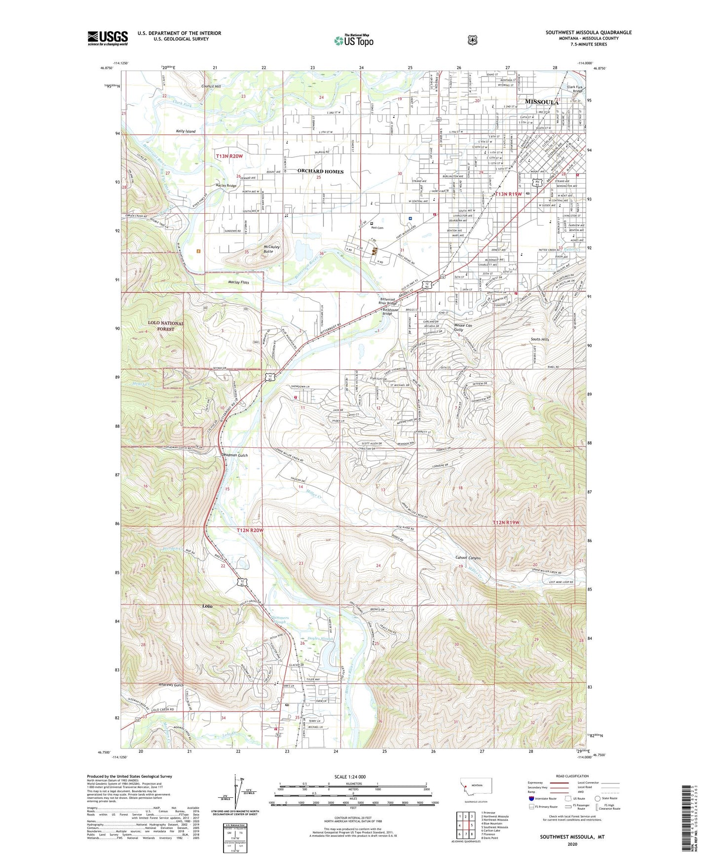
2020 topographic map quadrangle Southwest Missoula in the state of Montana. Scale: 1:24000. Based on the newly updated USGS 7.5' US Topo map series, this map is in the following counties: Missoula. The map contains contour data, water features, and other items you are used to seeing on USGS maps, but also has updated roads and other features. This is the next generation of topographic maps. Printed on high-quality waterproof paper with UV fade-resistant inks.
Quads adjacent to this one:
West: Blue Mountain
Northwest: Primrose
North: Northwest Missoula
Northeast: Northeast Missoula
East: Southeast Missoula
Southeast: Davis Point
South: Florence
Southwest: Carlton Lake
Contains the following named places: 12N19W05BACB01 Well, 12N19W06ACCC01 Well, 12N19W06ACCC02 Well, 12N19W06BB__01 Well, 12N19W06BBAB01 Well, 12N19W06BBBA01 Well, 12N19W06BBBB01 Well, 12N19W06BBDB01 Well, 12N19W06BDBA01 Well, 12N19W12BABC01 Well, 12N19W12BCDA01 Well, 12N19W12DAAD01 Well, 12N19W13CAAA01 Well, 12N19W18BB__01 Well, 12N19W18BB__02 Well, 12N19W19AC__01 Well, 12N19W20DBDC01 Well, 12N20W01AA__01 Well, 12N20W01AAC_01 Well, 12N20W01AB__01 Well, 12N20W01ABC_01 Well, 12N20W01AC__01 Well, 12N20W01AC__02 Well, 12N20W01ACA_01 Well, 12N20W01CC__01 Well, 12N20W01CD__01 Well, 12N20W01D___01 Well, 12N20W01DA__01 Well, 12N20W01DA__02 Well, 12N20W01DAAC01 Well, 12N20W01DACA01 Well, 12N20W01DB__01 Well, 12N20W01DC__01 Well, 12N20W02ABC_02 Well, 12N20W02CA__01 Well, 12N20W02CA__02 Well, 12N20W02CB__01 Well, 12N20W02CD__01 Well, 12N20W02CD__02 Well, 12N20W02CD__03 Well, 12N20W02D___02 Well, 12N20W03DCCD01 Well, 12N20W10AA__01 Well, 12N20W10BAAB01 Well, 12N20W11AB__01 Well, 12N20W11AD__01 Well, 12N20W11BACC01 Well, 12N20W12AD__01 Well, 12N20W12BB__01 Well, 12N20W12BB__02 Well, 12N20W14BCAB01 Well, 12N20W22ADAC01 Well, 12N20W22ADAC02 Well, 12N20W22ADAC03 Well, 12N20W22ADAC04 Well, 12N20W25ACCA01 Well, 12N20W25ACCA02 Well, 12N20W25CAAB01 Well, 12N20W26CACC01 Well, 12N20W26CCDD01 Well, 12N20W34CAB_01 Well, 12N20W34CBD_01 Well, 12N20W34DBAD01 Well, 12N20W35CBAB01 Well, 13N19W19CA__01 Well, 13N19W19CA__02 Well, 13N19W19CD__01 Well, 13N19W19DBDB01 Well, 13N19W20AC__01 Well, 13N19W20CB__01 Well, 13N19W20DA__01 Well, 13N19W21AC__01 Well, 13N19W21AC__02 Well, 13N19W21ADC_01 Well, 13N19W21BD__01 Well, 13N19W21CD__01 Well, 13N19W21DC__01 Well, 13N19W28DC__01 Well, 13N19W29AC__01 Well, 13N19W29CD__01 Well, 13N19W29DA__02 Well, 13N19W29DADD01 Well, 13N19W30AA__01 Well, 13N19W30AC__01 Well, 13N19W30ACA_01 Well, 13N19W30ACA_02 Well, 13N19W30ADBA01 Well, 13N19W30BA__01 Well, 13N19W30BA__02 Well, 13N19W30BDA_01 Well, 13N19W30CD__01 Well, 13N19W30DCAD01 Well, 13N19W30DD__01 Well, 13N19W30DD__02 Well, 13N19W31BAC_01 Well, 13N19W31BDAC01 Well, 13N19W31CC__01 Well, 13N19W31CC__02 Well, 13N19W31CD__01 Well, 13N19W31DC__01 Well, 13N19W32AD__01 Well, 13N19W32BB__01 Well, 13N19W32BC__01 Well, 13N19W32BD__01 Well, 13N19W32CD__01 Well, 13N19W32DD__01 Well, 13N19W32DD__02 Well, 13N19W33BA__01 Well, 13N19W33BC__01 Well, 13N20W22BD__01 Well, 13N20W24DA__01 Well, 13N20W24DADC01 Well, 13N20W25AA__01 Well, 13N20W25AACC01 Well, 13N20W25CD__01 Well, 13N20W25CDD_01 Well, 13N20W26AA__01 Well, 13N20W26AB__01 Well, 13N20W26DC__01 Well, 13N20W26DD__01 Well, 13N20W26DDCD01 Well, 13N20W27CC__01 Well, 13N20W27DC__01 Well, 13N20W34BBBA01 Well, 13N20W35AC__01 Well, 13N20W35BA__01 Well, 13N20W35BBBB01 Well, 59801, Ahern Trailer Court, Andrews Gulch, Big Flat Ditch, Bitterroot Gateway Trailer Court, Bitterroot Natural Medicine Clinic, Bitterroot River, Bitterroot River Bridge, Blue Mountain Clinic, Blue Mountain Equestrian and Hiking Trail, Blue Mountain Nature Trail National Recreation Trail, Blue Mountain Recreation Area, Blue Mountain Trailer Park, Boyd Park, Buckhouse Bridge, Buckhouse Bridge Fishing Access Site, Butler Chiropractic Health and Research Clinic, Cahoot Canyon, Caras Plaza, Chapman Chiropractic Clinic, Clark Fork Bridge, Council Hill, Cozy Court, Deadman Gulch, Doyles Slough, Dunham Stage Station, Elms Park, Fairway Shopping Center, First Care, Flor-Haven Home, Foleys Trailer Court, Foothills Chiropractic Center PC, Fort Missoula, Fort Missoula Park, Fort Missoula Post Cemetery, Franklin Park, Garland Park, Hawthorne House, Hayes, Hayes Creek, High Park, Hillside Place, Holiday Trailer Court, Holiday Village Shopping Center, Hollyhock Trailer Court, Kelly Island, Kelly Island Fishing Access Site, KGVO-AM (Missoula), KLCY-AM (East Missoula), KMSO-FM (Missoula), Larchmont Golf Course, Lewis and Clark Shopping Center, Linda Vista Public Golf Course, Lipske Trailer Court, Lolo, Lolo Census Designated Place, Lolo Family Practice Clinic - Western Montana Clinic, Lolo Fishing Access Site, Maclay Bridge, Maclay Flats, McCauley Butte, McCormick Park, McLeod Park, Memorial Rose Garden, Memorial Rose Gardens, Mental Health Center, Miller Creek, Missoula Country Club, Missoula County Fairgrounds, Missoula Family Medical Center, Missoula Unit Heliport, MJB Trailer Court, Moose Can Gully, Mormon Creek, Now Care Western Montana Clinic, O'Brien Creek, Orchard Homes, Orchard Homes Census Designated Place, Pattee Creek, Pheasant Run Park, Playfair Park, Plummers Slough, Post, Sacajawea Park, Saint Patrick Hospital Heliport, Skyview Park, Sleeman Creek, Smith Spur, South Center, South Hills, Southgate Mall, Southside Lions Park, Spartan Park, Spurgin Park, State Drive-In, Sunset Memorial Park, Town and Country Shopping Center, Travellers Rest Trailer Court, Trempers Shopping Center, Two River Trailer Park, Vietnam Veterans Memorial, Village Health Care Center, Village Senior Residence, Wapikiya Park, Washington Park, West Acres Trailer Park, Whitaker Park, Worden Creek