MyTopo
Primrose Montana US Topo Map
Couldn't load pickup availability
Also explore the Primrose Forest Service Topo of this same quad for updated USFS data
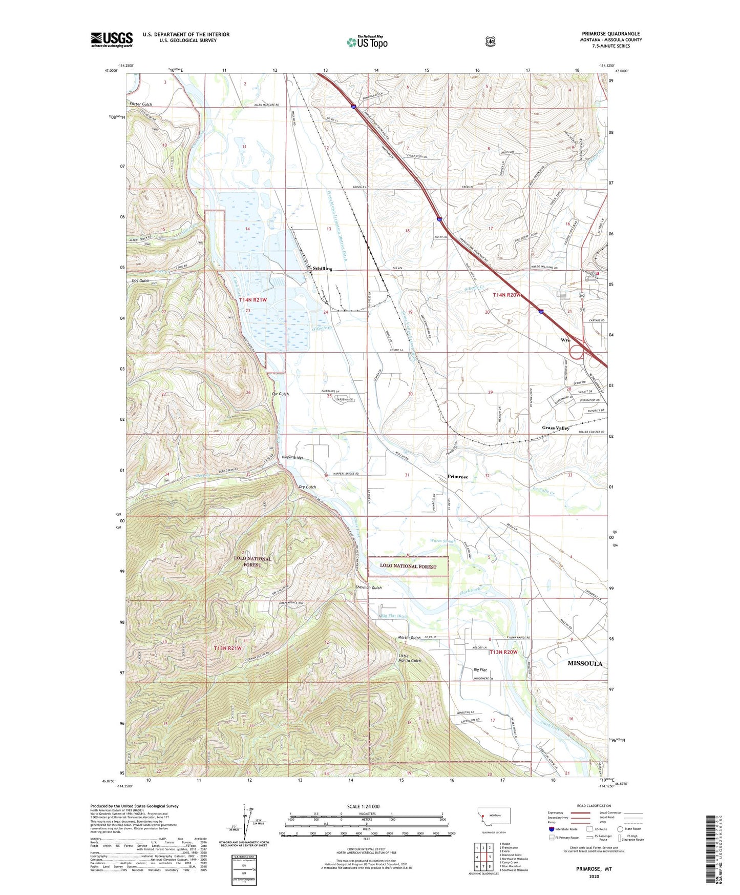
2024 topographic map quadrangle Primrose in the state of Montana. Scale: 1:24000. Based on the newly updated USGS 7.5' US Topo map series, this map is in the following counties: Missoula. The map contains contour data, water features, and other items you are used to seeing on USGS maps, but also has updated roads and other features. This is the next generation of topographic maps. Printed on high-quality waterproof paper with UV fade-resistant inks.
Quads adjacent to this one:
West: Diamond Point
Northwest: Huson
North: Frenchtown
Northeast: Evaro
East: Northwest Missoula
Southeast: Southwest Missoula
South: Blue Mountain
Southwest: Camp Creek
This map covers the same area as the classic USGS quad with code o46114h2.
Contains the following named places: 13N20W04BC__01 Well, 13N20W04CB__01 Well, 13N20W06AA__03 Well, 13N20W08CBB_01 Well, 13N20W08DA__01 Well, 13N20W09BA__01 Well, 13N20W17BB__01 Well, 13N20W21BB__01 Well, 13N21W01DCAD01 Well, 13N21W11AADC01 Well, 14N20W07DB__01 Well, 14N20W07DD__01 Well, 14N20W08DDCC01 Well, 14N20W09DD__01 Well, 14N20W19BD__01 Well, 14N20W19CB__01 Well, 14N20W20BB__01 Well, 14N20W21BB__01 Well, 14N20W21BD__01 Well, 14N20W28AB__01 Well, 14N20W28DA__01 Well, 14N20W28DBDD01 Well, 14N20W28DCCC01 Well, 14N20W29DCCA01 Well, 14N20W30CC__01 Well, 14N20W31AA__01 Well, 14N20W31BB__01 Well, 14N20W31BD__01 Well, 14N20W31DA__01 Well, 14N20W31DB__01 Well, 14N20W31DD__01 Well, 14N20W32BB__01 Well, 14N20W32CB__01 Well, 14N20W32CB__02 Well, 14N20W32DC__01 Well, 14N20W32DCCA01 Well, 14N20W33CC__01 Well, 14N21W01DDBB01 Well, 14N21W02DC__01 Well, 14N21W11ABAB01 Well, 14N21W11BA__01 Well, 14N21W11CA__01 Well, 14N21W12DB__01 Well, 14N21W13AB__01 Well, 14N21W13BB__01 Well, 14N21W13BB__02 Well, 14N21W13BBAA01 Well, 14N21W13CACC01 Well, 14N21W13CD__01 Well, 14N21W13DB__01 Well, 14N21W13DC__02 Well, 14N21W13DCDA01 Well, 14N21W13DDCA01 Well, 14N21W13DDCC01 Well, 14N21W14DA__01 Well, 14N21W14DB__01 Well, 14N21W23AA__01 Well, 14N21W24AC__01 Well, 14N21W24AC__02 Well, 14N21W24BA__01 Well, 14N21W24BA__03 Well, 14N21W24BA__04 Well, 14N21W24BA__05 Well, 14N21W24BA__06 Well, 14N21W24BAAC01 Well, 14N21W24BAAC02 Well, 14N21W24DA__01 Well, 14N21W24DB__01 Well, 14N21W24DBA_01 Well, 14N21W25AB__01 Well, 14N21W25ABCC01 Well, 14N21W25AC__01 Well, 14N21W25BCAA01 Well, 14N21W25BCAC01 Well, 14N21W25CADD01 Well, 14N21W25CADD02 Well, 14N21W25CBA_01 Well, 14N21W25CBA_02 Well, 14N21W25CCDA01 Well, 14N21W25CCDA02 Well, 14N21W25DA__01 Well, 14N21W25DD__01 Well, 14N21W36BD__01 Well, 14N21W36DD__01 Well, 59804, Albert Creek, Ardrum, Ardrum Post Office, Big Flat, Council Grove, Council Grove State Park, Cyr Gulch, Deep Creek, Deep Creek Fishing Access Site, Dog Gulch, Dry Gulch, Frenchtown Rural Fire District Station 6, Frenchtown Rural Fire District Station 7, Gaspard, Grass Valley, Grass Valley French Ditch, Grass Valley Post Office, Grass Valley School, Harper Bridge, Jellystone RV Park, Jim and Marys RV Park, La Valle Creek, Little Martin Gulch, Martin Gulch, Mellady, O'Keefe Creek, Primrose, Rock Creek, Schilling, Schilling Siding, Sherman Gulch, Sherman Gulch Beacon, Skyline Trailer Court, Wagon Wheel Trailer Court, Warm Slough, Wye Census Designated Place