
MyTopo
Three Forks Montana US Topo Map
Couldn't load pickup availability
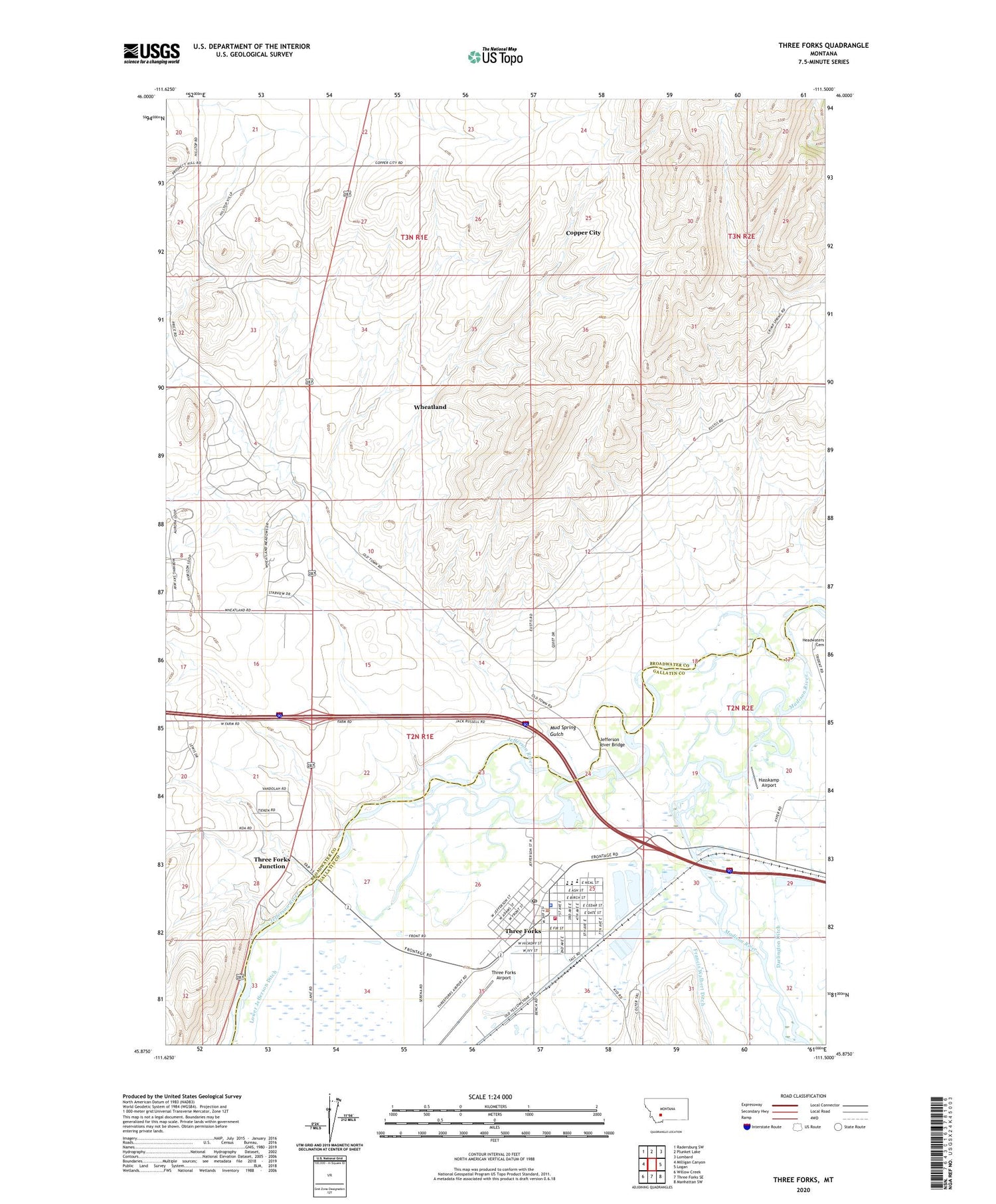
2020 topographic map quadrangle Three Forks in the state of Montana. Scale: 1:24000. Based on the newly updated USGS 7.5' US Topo map series, this map is in the following counties: Broadwater, Gallatin. The map contains contour data, water features, and other items you are used to seeing on USGS maps, but also has updated roads and other features. This is the next generation of topographic maps. Printed on high-quality waterproof paper with UV fade-resistant inks.
Quads adjacent to this one:
West: Milligan Canyon
Northwest: Radersburg SW
North: Plunket Lake
Northeast: Lombard
East: Logan
Southeast: Manhattan SW
South: Three Forks SE
Southwest: Willow Creek
Contains the following named places: 02N01E04BCAA01 Well, 02N01E04BDCC01 Well, 02N01E04DBDC01 Well, 02N01E04DBDD01 Well, 02N01E08DDCA01 Well, 02N01E17ADBC01 Well, 02N01E17DAAD01 Well, 02N01E24BADA01 Well, 02N01E24DDA_01 Well, 02N01E24DDAA01 Well, 02N01E25AACC01 Well, 02N01E25AB__01 Well, 02N01E25BDBB01 Well, 02N01E25CBBD01 Well, 02N01E26AA__01 Well, 02N01E26DCDC01 Well, 02N01E26DDDA01 Well, 02N01E27BCCB01 Well, 02N01E27CBD_01 Well, 02N01E28DBDC01 Well, 02N01E28DCAB01 Well, 02N01E28DCBC01 Well, 02N01E34AAAD01 Well, 02N01E34AABA01 Well, 02N01E35BABA01 Well, 02N01E35BABA02 Well, 02N01E35DDDA01 Well, 02N01E36BAAC01 Well, 02N01E36BCBD01 Well, 02N01E36BCDD01 Well, 02N01E36CBA_01 Well, 02N02E19CBCC01 Well, 02N02E19CCAB01 Well, 02N02E19CCB_01 Well, 02N02E19CCCB01 Well, 02N02E19CCCB02 Well, 02N02E20CABC01 Well, 02N02E20CBDC01 Well, 02N02E20CCAA01 Well, 02N02E20CDAC01 Well, 02N02E29BABD01 Well, 02N02E29BABD02 Well, 02N02E30CDAA01 Well, 02N02E30DCBC01 Well, 59752, Blackbird Fishing Access Site, Christian Center Assembly of God, Church of Christ, City of Three Forks, Copper City, Drouillard Fishing Access Site, First Baptist Church, Fort Henry, Grace Lutheran Church, Harvest States Co-operative Elevator, Haskin Bridge, Hasskamp Airport, Headwaters Heritage Museum, Headwaters Public Golf Course, Holy Family Parish, Jefferson, Jefferson River, Jefferson River Bridge, Madison Post Office, Madison River, Memorial Park, Milwaukee Fishing Access Site, Milwaukee Hospital, Milwaukee Park, Mud Spring Gulch, Murphys Trailer Court, Pacabo Dam, Peterson Park, Pyfer Bridge, Sacajawea Park, Stevenson Park, The Church of Jesus Christ of Latter Day Saints, Three Forks, Three Forks Airport, Three Forks Community Library, Three Forks Hospital, Three Forks Junction, Three Forks KOA Kampground, Three Forks of the Missouri Historical Marker, Three Forks Police Department, Three Forks Pond, Three Forks Ponds Fishing Access Site, Three Forks Post Office, Three Forks Schools, Three Forks Volunteer Fire Department and Three Forks Area Ambulance Station 1, Three Rivers Clinic, Tom Bertagnolli Park, United Methodist Church, Wheatland Census Designated Place


