MyTopo
Broken Bow Nebraska US Topo Map
Couldn't load pickup availability
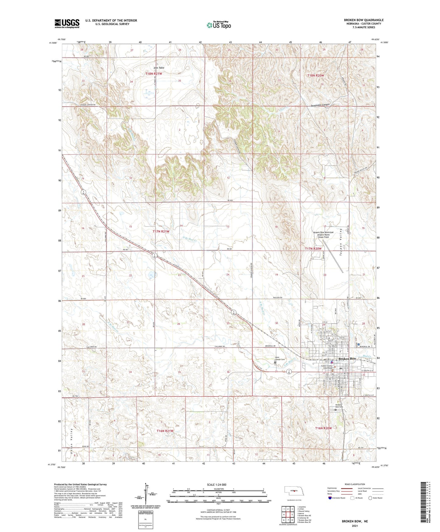
2021 topographic map quadrangle Broken Bow in the state of Nebraska. Scale: 1:24000. Based on the newly updated USGS 7.5' US Topo map series, this map is in the following counties: Custer. The map contains contour data, water features, and other items you are used to seeing on USGS maps, but also has updated roads and other features. This is the next generation of topographic maps. Printed on high-quality waterproof paper with UV fade-resistant inks.
Quads adjacent to this one:
West: Merna
Northwest: Anselmo
North: Lillian
Northeast: Round Valley
East: Broken Bow NE
Southeast: Broken Bow SE
South: Broken Bow SW
Southwest: Callaway SE
This map covers the same area as the classic USGS quad with code o41099d6.
Contains the following named places: Assembly of God Church, Berean Fundamental Church, Broken Bow, Broken Bow Cemetery, Broken Bow Clinic, Broken Bow Country Club, Broken Bow Fire Department Station 1, Broken Bow Fire Department Station 2, Broken Bow High School, Broken Bow Historical Marker, Broken Bow Middle School, Broken Bow Municipal Airport/Keith Glaze Field, Broken Bow Police Department, Broken Bow Post Office, Broken Bow Public Library, Broken Bow Rural Fire District 1, Central Nebraska Medical Clinic, Christian Life Center, Church of Christ, Church of God, Church of the Nazarene, City of Broken Bow, Custer Center Church, Custer Center School, Custer Community Park, Custer County, Custer County Courthouse, Custer County Historical Museum, Custer County Sheriff's Office, Custer Elementary School, Custer United Methodist Parish, East Table, East Table School, Evangelical Free Church, Faith Bible Fellowship, First Baptist Church, First Mennonite Church, First Presbyterian Church, Gremm School, Heritage Hall Nursing Home, Highland, Indian Hills Park, Jehovahs Witnesses Kingdom Hall, Jennie M Melham Memorial Medical Center, KCNI-AM (Broken Bow), Melham Park, Nebraska State Grange Historical Marker, North Branch Mud Creek, North Grade School, North Park, North Park Elementary School, Our Saviour Lutheran Church, Pioneer Community Mental Health Center, Prairie Center School, Prairie Eyecare Center, Saint Johns Episcopal Church, Saint Joseph Catholic Church, Saint Joseph Cemetery, Saint Pauls Lutheran Church, Sandhills Manor, Seventh Day Adventist Church, South Branch Mud Creek, South Park, Sunny Dell School, Tappan Valley School, The Church of Jesus Christ of Latter Day Saints, Tomahawk Park, Tomahawk Park Campground, Union Valley School, Vannice School, Wagon Wheel Motel and Camp Grounds, ZIP Code: 68822