MyTopo
Dunbar Nebraska US Topo Map
Couldn't load pickup availability
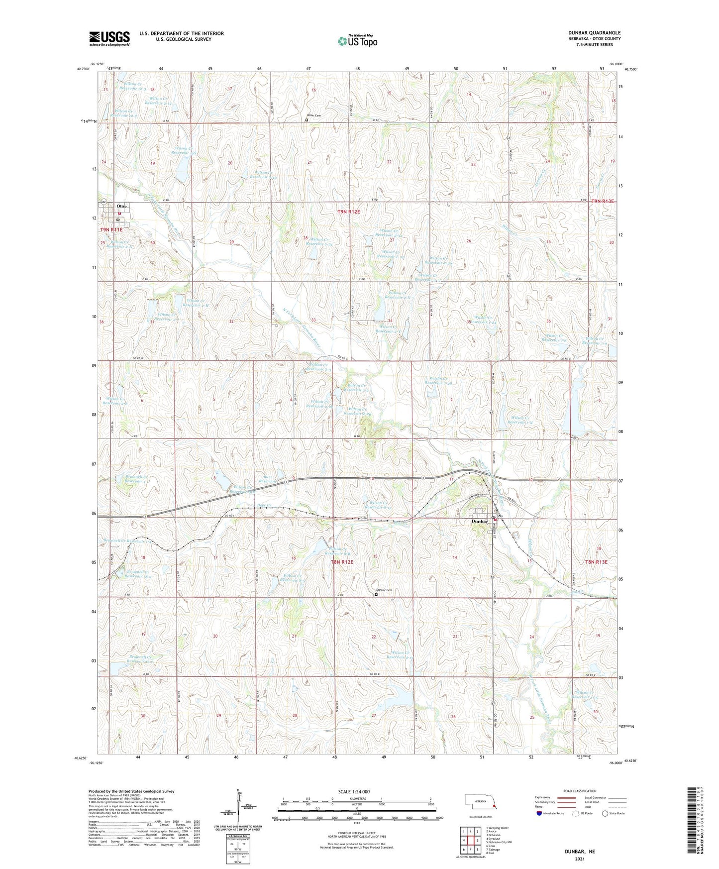
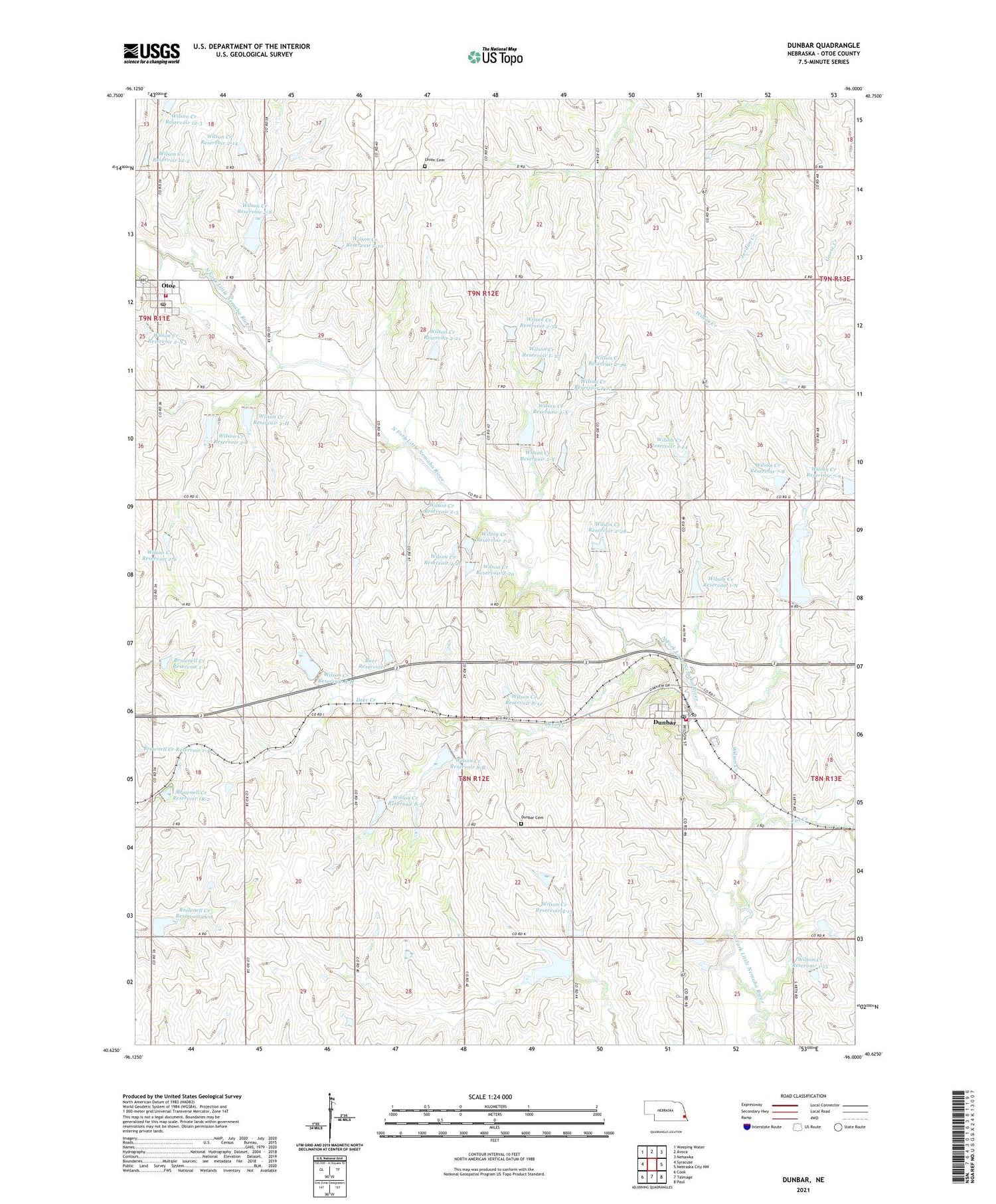
2021 topographic map quadrangle Dunbar in the state of Nebraska. Scale: 1:24000. Based on the newly updated USGS 7.5' US Topo map series, this map is in the following counties: Otoe. The map contains contour data, water features, and other items you are used to seeing on USGS maps, but also has updated roads and other features. This is the next generation of topographic maps. Printed on high-quality waterproof paper with UV fade-resistant inks.
Quads adjacent to this one:
West: Syracuse
Northwest: Weeping Water
North: Avoca
Northeast: Nehawka
East: Nebraska City NW
Southeast: Paul
South: Talmage
Southwest: Cook
Contains the following named places: Berlin Election Precinct, Berner Dam, Brownell Creek Dam 1-1, Brownell Creek Dam 16-A, Brownell Creek Reservoir 1-1, Brownell Creek Reservoir 16-A, Brownell Creek Reservoir 18-2, Burr Dam, Burr Reservoir, Deer Creek, Delaware Election Precinct, Dieter Dam, Dunbar, Dunbar Cemetery, Dunbar Post Office, Dunbar Presbyterian Church, Dunbar Volunteer Fire Department, Farmers Union Co-op Elevator, Fox Creek, Gibbs Dam, Howe School, Main School, McWilliams School, N F Little Nemaha Dam 4-F, N F Little Nemaha Reservoir 4-F, Nehawka Farmers Co-op Elevator, Otoe, Otoe Post Office, Otoe Public School, Otoe Volunteer Fire Department, Peterson Dam, Prairie Owl Campground, Reuter Dam, Smallfoot Public School, Township of Berlin, Township of Delaware, Turlington Post Office, Turllington, Union Cemetery, Village of Dunbar, Village of Otoe, Wilson Creek, Wilson Creek Dam 1-15, Wilson Creek Dam 12-2, Wilson Creek Dam 12-3, Wilson Creek Dam 1-24, Wilson Creek Dam 1-N, Wilson Creek Dam 2-2, Wilson Creek Dam 2-21, Wilson Creek Dam 2-23, Wilson Creek Dam 2-26, Wilson Creek Dam 2-27, Wilson Creek Dam 2-28, Wilson Creek Dam 2-2b, Wilson Creek Dam 2-32, Wilson Creek Dam 2-6, Wilson Creek Dam 2-H, Wilson Creek Dam 2-J, Wilson Creek Dam 2-N, Wilson Creek Dam 2-S, Wilson Creek Dam 2-X, Wilson Creek Dam 2-Y, Wilson Creek Dam 4-11, Wilson Creek Dam 4-15, Wilson Creek Dam 7-8, Wilson Creek Dam 7-9, Wilson Creek Dam 7-A, Wilson Creek Dam 8-12, Wilson Creek Dam 8-5, Wilson Creek Dam 8-B, Wilson Creek Dam 8-H, Wilson Creek Reservoir 1-15, Wilson Creek Reservoir 12-2, Wilson Creek Reservoir 12-3, Wilson Creek Reservoir 1-24, Wilson Creek Reservoir 1-N, Wilson Creek Reservoir 2-14, Wilson Creek Reservoir 2-19, Wilson Creek Reservoir 2-2, Wilson Creek Reservoir 2-21, Wilson Creek Reservoir 2-26, Wilson Creek Reservoir 2-27, Wilson Creek Reservoir 2-28, Wilson Creek Reservoir 2-2b, Wilson Creek Reservoir 2-3, Wilson Creek Reservoir 2-32, Wilson Creek Reservoir 2-6, Wilson Creek Reservoir 2-H, Wilson Creek Reservoir 2-J, Wilson Creek Reservoir 2-N, Wilson Creek Reservoir 2-S, Wilson Creek Reservoir 2-X, Wilson Creek Reservoir 2-Y, Wilson Creek Reservoir 4-15, Wilson Creek Reservoir 7-8, Wilson Creek Reservoir 7-A, Wilson Creek Reservoir 8-12, Wilson Creek Reservoir 8-5, Wilson Creek Reservoir 8-B, Wilson Creek Reservoir 8-H, Wilson Creek Reservoir I- 23, Wilson Creek Reservoir Z-2a, Wilson Creek State Wildlife Management Area, ZIP Codes: 68346, 68417