MyTopo
Berlin New Hampshire US Topo Map
Couldn't load pickup availability
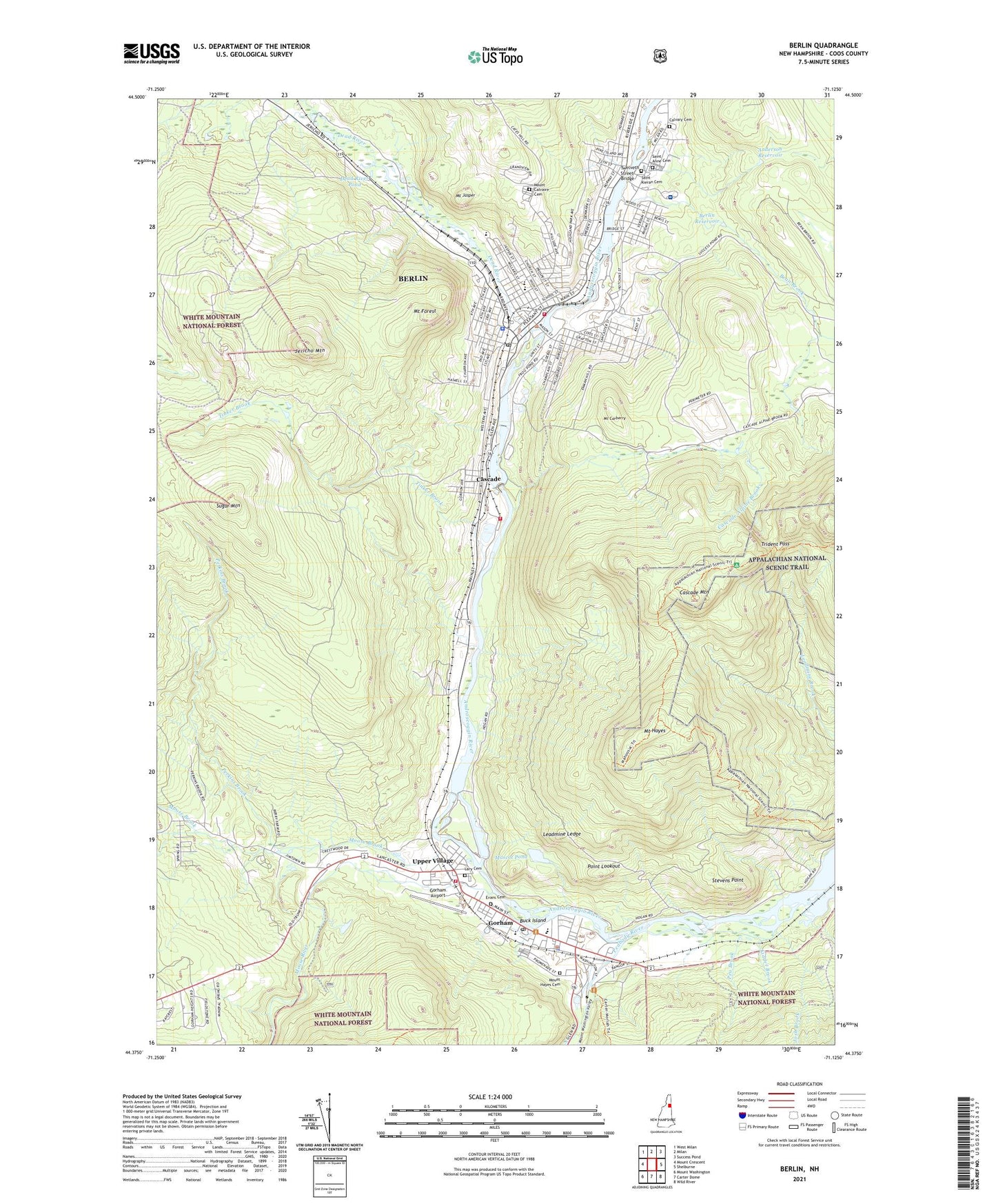
2021 topographic map quadrangle Berlin in the state of New Hampshire. Scale: 1:24000. Based on the newly updated USGS 7.5' US Topo map series, this map is in the following counties: Coos. The map contains contour data, water features, and other items you are used to seeing on USGS maps, but also has updated roads and other features. This is the next generation of topographic maps. Printed on high-quality waterproof paper with UV fade-resistant inks.
Quads adjacent to this one:
West: Mount Crescent
Northwest: West Milan
North: Milan
Northeast: Success Pond
East: Shelburne
Southeast: Wild River
South: Carter Dome
Southwest: Mount Washington
Contains the following named places: Anderson Dam, Anderson Reservoir, Androscoggin Ranger Station, Androscoggin River Reservoir, Androscoggin Valley Country Club, Androscoggin Valley Hospital, Androscoggin Valley Hospital Library, Bartlett Elementary School, Bean Brook, Berlin, Berlin City Hall, Berlin Emergency Medical Services, Berlin Fire Department, Berlin Junior High School, Berlin Police Department, Berlin Post Office, Berlin Public Library, Berlin Reservoir, Berlin Senior High School, Berlin United Church of Christ, Brown Company House, Brown Elementary School, Buck Island, Calvary Cemetery, Cascade, Cascade Alpine Brook, Cascade Alpine Water Supply Dam, Cascade Brook Reservoir, Cascade Dam, Cascade Mill Aeration Lagoon Dam, Cascade Mill Lagoons, Cascade Mountain, Christian Life Center, Church of the Ressurection Eastern Orthodox Church, Community Baptist School, Community Bible Academy, Coos County Courthouse, Cross Power Dam, Dead River, Dead River Pond, Edward Fenn School, Evans Cemetery, First Baptist Church, First Congregational Church, Gateway Trailer Park, Gorham, Gorham Airport, Gorham Census Designated Place, Gorham Common, Gorham Dam, Gorham Dam Brown Company, Gorham Emergency Medical Services, Gorham Fire Department Station 1, Gorham Fire Department Station 2, Gorham High School, Gorham Historical Society Museum, Gorham Middle School, Gorham Police Department, Gorham Post Office, Gorham Public Library, Gorham Railroad Station, Gorham Shop and Save Shopping Center, Gorham Town Hall, Gorham United Methodist Church, Group Camping Area Number 1, Group Mountain Camping Area Number 2, Guardian Angel Roman Catholic Church, Guardian Angel School, Hillside Elementary School, Holy Family Roman Catholic Church, J Brodie Smith Dam, J Brodie Smith Reservoir, Jericho Brook, Jericho Mountain, Josh Brook, Kidder Brook, Kingdom Hall of Jehovahs Witnesses, Lary Cemetery, Leadmine Ledge, Leadmine State Forest, Marston Elementary School, Mascot Pond, Moose Brook, Moose Brook State Park, Moose River, Mount Calvaire Cemetery, Mount Carberry, Mount Forest, Mount Hayes, Mount Hayes Cemetery, Mount Jasper, Mount Washington Valley, Mountaineer Club Cabin, North Country Baptist Church, Northern Forest Heritage Park, Northern Forest Heritage Park Headquarters, Northern White Mountains Chamber of Commerce, Northwoods Christian Church, Notre Dame High School, Pea Brook, Peabody River, Perkins Brook, Point Lookout, Riverside Dam, Saint Anne Cemetery, Saint Annes Roman Catholic Church, Saint Barnabas Episcopal Church, Saint Joseph Roman Catholic Church, Saint Josephs School, Saint Jude Charismatic Church, Saint Kieran Cemetery, Saint Kieran Roman Catholic Church, Saint Michael Catholic School, Saint Paul Lutheran Church, Salvation Army, Sawmill Dam, Schoolhouse Brook, Seventh Day Adventist Church, Sinclair Trail, Stevens Point, Sugar Mountain, Tinker Brook, Town of Gorham, Trident Pass, Twelveth Street Bridge, Upper Village, WBRL-AM (Berlin), WKCB Radio Tower (Biloxi), WMOU-AM (Berlin)