MyTopo
Hillsboro New Hampshire US Topo Map
Couldn't load pickup availability
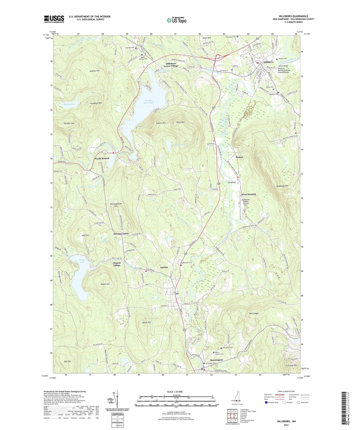
2021 topographic map quadrangle Hillsboro in the state of New Hampshire. Scale: 1:24000. Based on the newly updated USGS 7.5' US Topo map series, this map is in the following counties: Hillsborough. The map contains contour data, water features, and other items you are used to seeing on USGS maps, but also has updated roads and other features. This is the next generation of topographic maps. Printed on high-quality waterproof paper with UV fade-resistant inks.
Quads adjacent to this one:
West: Stoddard
Northwest: Washington
North: Hillsboro Upper Village
Northeast: Henniker
East: Deering
Southeast: Greenfield
South: Peterborough North
Southwest: Dublin
Contains the following named places: Angus Lea Golf Course, Antrim, Antrim Census Designated Place, Antrim Center, Antrim Elementary School, Antrim Fire Department Station 2, Antrim Fire Department Station Headquarters and Emergency Medical Services, Antrim Girls Shelter School, Antrim Police Department, Antrim Post Office, Antrim Station, Appleton Cemetery, Bagley Pond, Ball Hill, Beard Brook, Bell Ledges, Bennington, Bennington Census Designated Place, Bennington Congregational Church, Bennington Country Store Post Office, Bennington Fire and Rescue, Bennington Police Dept, Bible Hill, Birchmere Camp, Butler Cemetery, Camp Sachem, Campbell Mountain, Campbell Pond, Campbell Pond Dam, Clinton Village, Cochran Brook, Contoocook Mills Industrial Site, Corkplain, Deering Fire and Rescue McCallister Station, Deering Fire and Rescue Murdough Station, Evas Marsh, Evergreen Cemetery, Franklin Pierce Lake, Gibson Mountain, Great Bridge, Great Brook, Great Brook School, Gregg Lake, Gregg Lake Dam, Hawthorne-Feather Airpark, Hedgehog Hill, Hillsboro, Hillsboro - Deering Elementary School, Hillsboro - Deering High School, Hillsboro - Deering Middle School, Hillsboro Chamber of Commerce, Hillsboro Lower Village, Hillsboro United Methodist Church, Hillsboro-Deering Railroad Covered Bridge, Hillsborough Census Designated Place, Hillsborough Fire Department, Hillsborough Police Department, Hillsborough Post Office, Hillsborough Town Offices, Holt Hill, Holton, Lily Pond, Maple Avenue Cemetery, Maplewood Cemetery, Meetinghouse Hill, Monadnock Power Station Dam, Mount Calvary Cemetery, Nahor Hill, North Branch, North Branch River, Oxbow Campground, Paper Mill Dam, Patten Hill, Pierce Elementary School, Pierce Power Dam, Pine Hill Cemetery, Preston Cemetery, Riley Mountain, Saint Mary Cemetery, Saint Marys Catholic Church, Shedd Brook, Steel Pond Dam, Steels Pond, Sulphur Hill, Sunnyside Cemetery, Town of Antrim, Town of Bennington, West Deering, WRCI-FM (Hillsboro), ZIP Codes: 03440, 03442