MyTopo
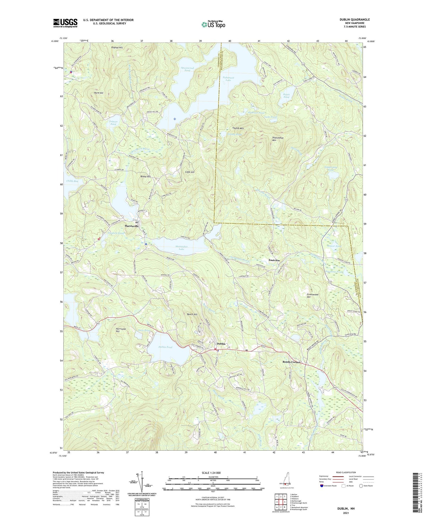
Dublin New Hampshire US Topo Map
Couldn't load pickup availability
2024 topographic map quadrangle Dublin in the state of New Hampshire. Scale: 1:24000. Based on the newly updated USGS 7.5' US Topo map series, this map is in the following counties: Cheshire, Hillsborough. The map contains contour data, water features, and other items you are used to seeing on USGS maps, but also has updated roads and other features. This is the next generation of topographic maps. Printed on high-quality waterproof paper with UV fade-resistant inks.
Quads adjacent to this one:
West: Marlborough
Northwest: Marlow
North: Stoddard
Northeast: Hillsboro
East: Peterborough North
Southeast: Peterborough South
South: Monadnock Mountain
Southwest: Troy
This map covers the same area as the classic USGS quad with code o42072h1.
Contains the following named places: Beaver Pond, Beech Hill, Beech Hill Hospital, Beech Hill Hospital Adolescent Unit School, Blood Hill, Bonds Corner, Brickyard Brook, Carpenter Marsh State Wildlife Management Area, Childs Bog, Childs Bog Dam, Cobb Hill, Dark Pond, Dinsmore Pond, Dublin, Dublin Christian Academy, Dublin Consolidated School, Dublin Country Club, Dublin Fire Department, Dublin Lake Historic District, Dublin Police Department, Dublin Pond, Dublin Pond Dam, Dublin Post Office, Dublin Village Historic District, Eastview, Emmanuel Protestant Episcopal Church, Evangelical Congregational Church, Filtrine Dam, Greenwood Hill, Half Moon Pond Dam, Harrisville, Harrisville Fire Department, Harrisville Historic District, Harrisville Police Dept, Harrisville Pond, Harrisville Pond Dam, Harrisville Post Office, Harrisville Rural District, Hinds Brook, Hunts Pond, Hunts Pond Dam, Hurd Hill, Hurricane Hill, Jacks Pond, Jaquith Brook, Juggernaut Pond, Lake Skatutakee, Lake Skatutakee Dam, Mud Pond, Mud Pond Dam, Nelson Fire and Rescue Station 1, Nelson Police Department, Nubanusit Brook Reservoir, Nubanusit Lake, Nubanusit Lake Dam, Osgood Hill, Peterson State Wildlife Management Area, Pumpelly Trail, Ryan State Wildlife Management Area, Saint Denis Church, Seaver Reservoir Dam, Shadrach Pond, Skatutakee Lake, Skatutakee Mountain, Spoonwood Pond, Spoonwood Pond Dam, Stanford Pond, Stanley Brook, Tenney Pond, Thumb Mountain, Tolman Pond, Town of Dublin, Town of Harrisville, Town of Nelson, ZIP Codes: 03444, 03450, 03457