MyTopo
Pittsfield New Hampshire US Topo Map
Couldn't load pickup availability
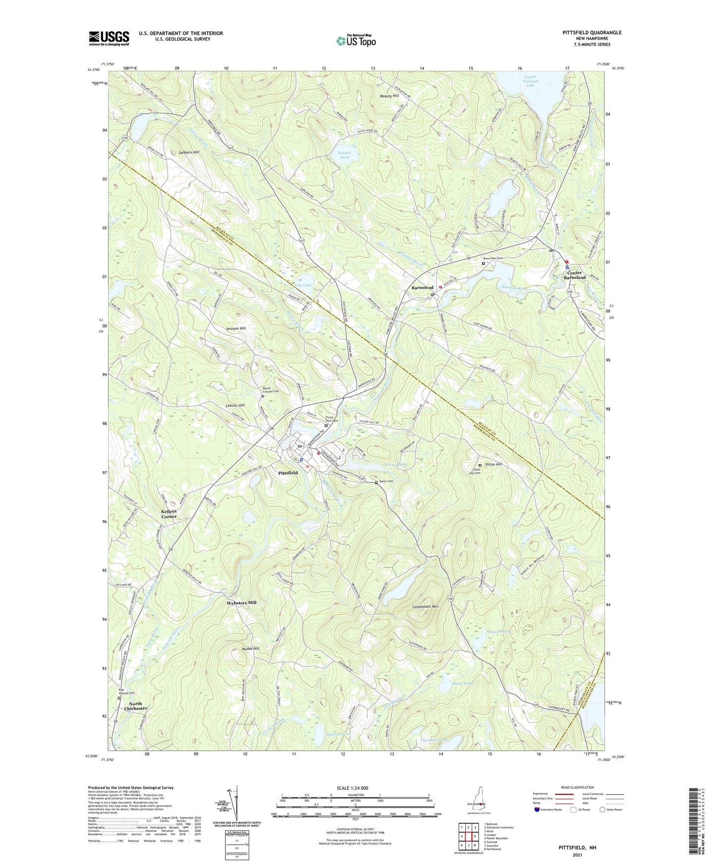
2021 topographic map quadrangle Pittsfield in the state of New Hampshire. Scale: 1:24000. Based on the newly updated USGS 7.5' US Topo map series, this map is in the following counties: Merrimack, Belknap, Rockingham. The map contains contour data, water features, and other items you are used to seeing on USGS maps, but also has updated roads and other features. This is the next generation of topographic maps. Printed on high-quality waterproof paper with UV fade-resistant inks.
Quads adjacent to this one:
West: Loudon
Northwest: Belmont
North: Gilmanton Ironworks
Northeast: Alton
East: Parker Mountain
Southeast: Northwood
South: Gossville
Southwest: Suncook
Contains the following named places: Advent Christian Church, Appleview Orchard, Barnstead, Barnstead Elementary School, Barnstead Fire and Rescue, Barnstead Fire Rescue Station 2, Barnstead Parade Church, Barnstead Parade Dam, Barnstead Post Office, Beauty Hill, Berry Cemetery, Berry Pond, Berry Pond Brook, Berry Pond Dam, Big River, Blake Pond, Carpenter Memorial Library, Catamount Mountain, Center Barnstead, Center Barnstead Police Dept, Center Barnstead Post Office, Chestnut Pond, Crooked Run, Eaton Pond, Floral Park Cemetery, Friends Meetinghouse, Huntress Pond, Jenness Hill, Kelley Brook, Kelleys Corner, Leavitt Hill, Lily Lake, Loudon School, Lougee Pond, Lower Suncook Lake, Mount Calvary Cemetery, North Chichester, Nudds Hill, Odiorne Pond, Perry Brook, Pine Ground Cemetery, Pittsfield, Pittsfield Census Designated Place, Pittsfield Center Historic District, Pittsfield Church of God, Pittsfield Community Center, Pittsfield Elementary School, Pittsfield Fairgrounds, Pittsfield Fire Department, Pittsfield High School, Pittsfield Middle School, Pittsfield Mill Dam, Pittsfield Police Department, Pittsfield Post Office, Rings Corner, Riverview Cemetery, Rollins Pond, Sanborn Brook, Sanborn Hill, Sanders Brook, Suncook Lake Dam, Suncook River Reservoir, Tilton Hill, Tilton Hill Cemetery, Town of Barnstead, Town of Pittsfield, Webster Stream, Websters Mill, Wheeler Brook, Whites Pond, Whites Pond Outlet Dam, ZIP Codes: 03218, 03263