MyTopo
Sunapee Lake North New Hampshire US Topo Map
Couldn't load pickup availability
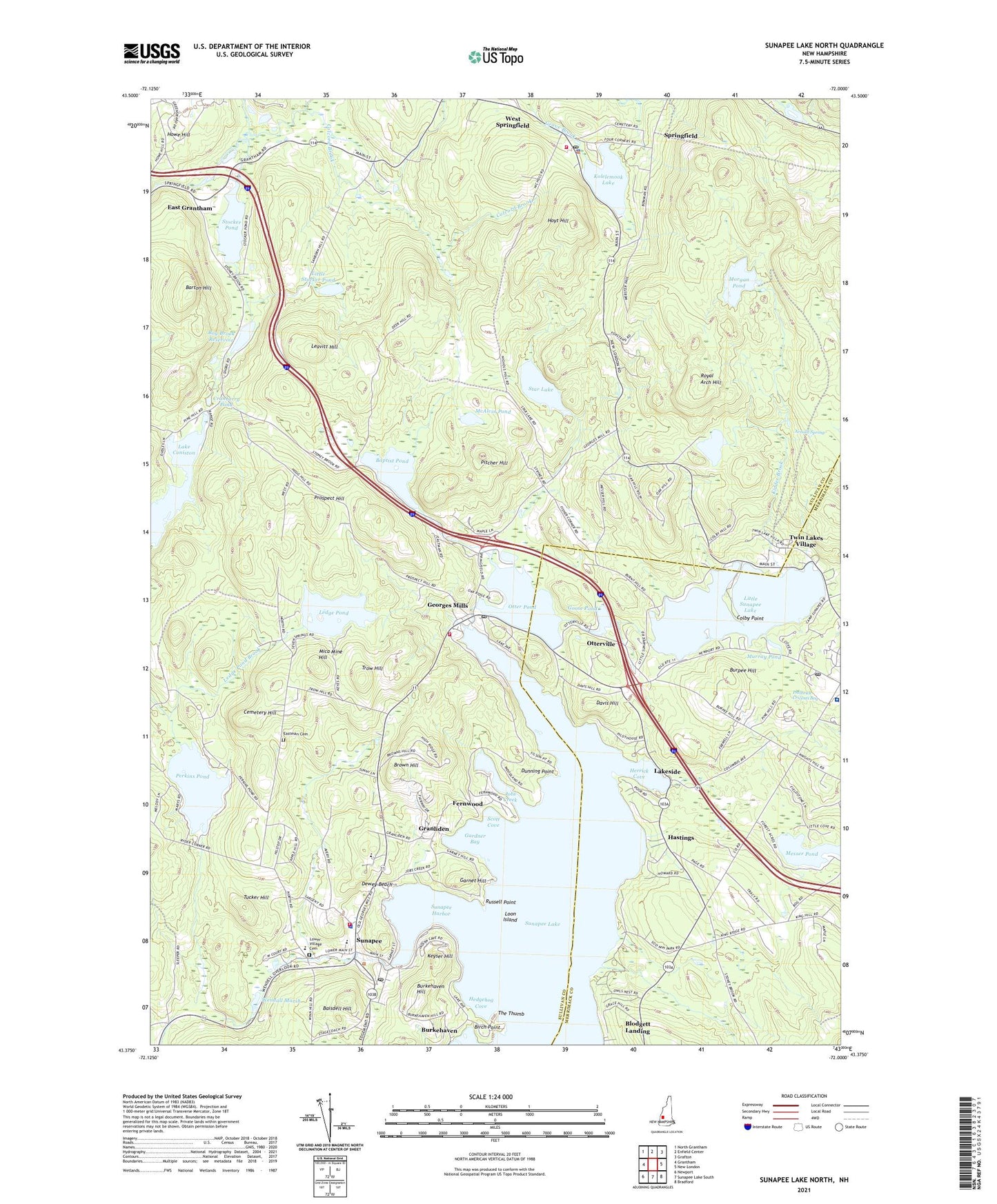
2024 topographic map quadrangle Sunapee Lake North in the state of New Hampshire. Scale: 1:24000. Based on the newly updated USGS 7.5' US Topo map series, this map is in the following counties: Sullivan, Merrimack. The map contains contour data, water features, and other items you are used to seeing on USGS maps, but also has updated roads and other features. This is the next generation of topographic maps. Printed on high-quality waterproof paper with UV fade-resistant inks.
Quads adjacent to this one:
West: Grantham
Northwest: North Grantham
North: Enfield Center
Northeast: Grafton
East: New London
Southeast: Bradford
South: Sunapee Lake South
Southwest: Newport
This map covers the same area as the classic USGS quad with code o43072d1.
Contains the following named places: Arnold Spring, Baisdell Hill, Baptist Pond, Barton Hill, Berchmans Hall, Birch Point, Blodgett Landing Census Designated Place, Bog Brook, Bog Brook Dam, Bog Brook Reservoir, Brown Hill, Bucklin Beach, Burkehaven, Burkehaven Hill, Burpee Hill, Camp Coniston (YMCA), Camp Sunapee, Cemetery Hill, Colby Point, Colcord Brook, Cranberry Pond, Davis Hill, Dewey Beach, Dewey Park, Dunning Point, Dutchman Pond, East Grantham, Eastman Brook, Eastman Cemetery, Fernwood, Gardner Bay, Garnet Hill, Georges Mills, Georges Mills Post Office, Gile Memorial Forest, Goose Pond, Goose Pond Dam, Gordon State Wildlife Management Area, Granliden, Hastings, Hedgehog Cove, Herrick Cove, Herrick Cove Lighthouse, Howe Hill, Hoyt Hill, Jobs Creek, Keyser Hill, Kidder Brook, Kolelemook Lake, Lake Coniston, Lake Sunapee Dam, Lakeside, Leavitt Hill, Ledge Pond, Lincoln and Allison Gordon Wildlife Management Area, Little Stocker Pond, Little Sunapee Lake, Loon Island, Loon Island Lighthouse, Lower Village, Lower Village Cemetery, McAlvin Pond, Messer Pond, Mica Mine Hill, Morgan Pond, Morgan Pond Dam, Mount Royal Academy, Murray Pond, New London Hospital, New London Post Office, Otter Pond, Otter Pond Dam, Otterville, Palazzi Pond, Perkins Pond, Philbrick Cricenti Bog, Pitcher Hill, Prospect Hill, Roby Corners, Royal Arch Hill, Russell Point, Saint Andrews Church, Scott Cove, Soo Nipi Park, Springfield, Springfield Police Department, Springfield Post Office, Springfield Town Forest, Springfield Volunteer Fire and Rescue Department Station, Star Lake, Star Lake Dam, Stocker Pond, Sunapee, Sunapee Central Elementary School, Sunapee Community Church, Sunapee Fire Department and Emergency Medical Services, Sunapee Fire Department and Rescue Station 2 Georges Mills Station, Sunapee Harbor, Sunapee Lake, Sunapee Lake Town Dam, Sunapee Middle and High School, Sunapee Middle School, Sunapee Police Department, Sunapee Post Office, Sunapee Town Hall, The Thumb, Town of Springfield, Town of Sunapee, Trow Hill, Tucker Hill, Twin Lakes Village, Wayside Chapel, Wendall Marsh, Wendall Marsh Dam, Wendell Marsh State Wildlife Management Area, West Springfield, Wildwood Forest Campground, ZIP Codes: 03284, 03751, 03782