MyTopo
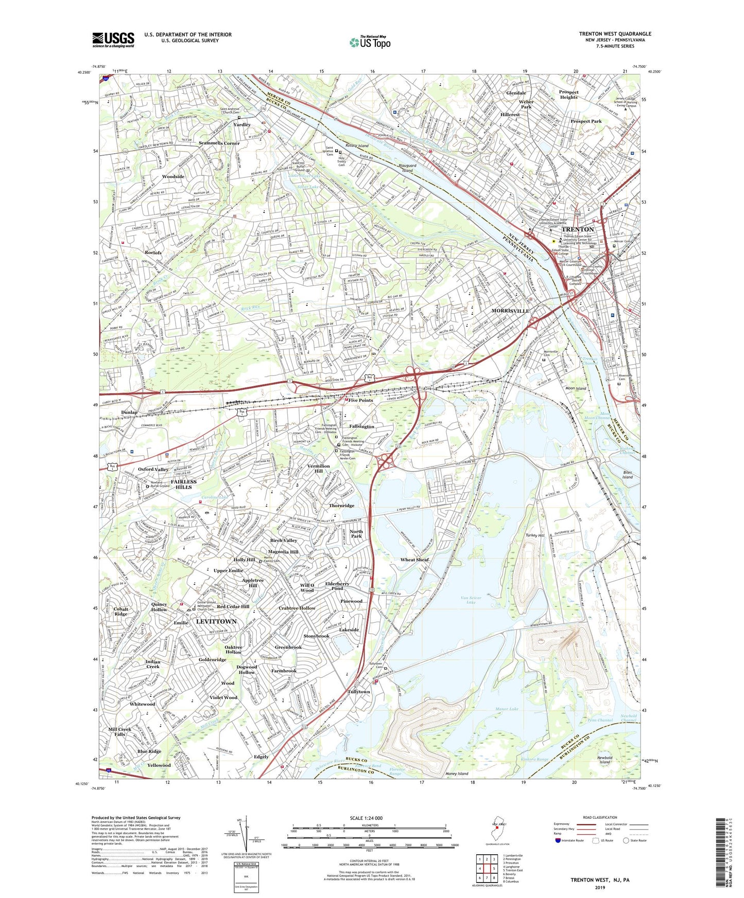
Trenton West New Jersey US Topo Map
Couldn't load pickup availability
2023 topographic map quadrangle Trenton West in the states of Pennsylvania, New Jersey. Scale: 1:24000. Based on the newly updated USGS 7.5' US Topo map series, this map is in the following counties: Mercer, Bucks, Burlington. The map contains contour data, water features, and other items you are used to seeing on USGS maps, but also has updated roads and other features. This is the next generation of topographic maps. Printed on high-quality waterproof paper with UV fade-resistant inks.
Quads adjacent to this one:
West: Langhorne
Northwest: Lambertville
North: Pennington
Northeast: Princeton
East: Trenton East
Southeast: Columbus
South: Bristol
Southwest: Beverly
Contains the following named places: 3-M Heliport, Alliance Landfill, Appletree Hill, Aria Health Hospital Bucks County Campus, Assunpink Creek, Belaire Trailer Court, Birch Valley, Blauguard Island, Bloomsdale Gardens, Blue Ridge, Borough of Morrisville, Borough of Tullytown, Borough of Yardley, Brock Creek, Brook Park, Brookfield, Buck Creek, Cabot Cabot and Forbes Industrial Park, Cadwalader Park, Cambridge Estates, Canterberry Estates, Capital Health System Regional Medical Center, Capital View, Caroline Lake, Carriage Hill, Cedar Lake Trailer Park, Chickenfoot Park, City of Trenton, Clearbrook, Clover Shopping Center, Cobalt Ridge, Cochran Channel, Crabtree Hollow, Curtis Lake, Delavue Manor, Dogwood Hollow, Drexelwood, Dunlap, East Side, Edge Hill, Edgely, Edgely Industrial Park, Edgewood Park, Elderberry Pond, Emilie, Emilie United Methodist Church Cemetery, Fairbridge, Fairless Hills, Fairless Hills Census Designated Place, Fairless Hills Shopping Center, Falls Industrial Park, Fallsington, Fallsington County Park, Fallsington Friends Meeting Cemetery - Hicksite, Fallsington Friends Meeting Cemetery - Orthodox, Fallsington Friends Newer Cemetery, Fallsington Highlands, Farmbrook, Five Mile Woods Forest Preserve, Five Point Shopping Center, Five Points, Florence Bend, Gaslight Shopping Center, Glen Wood, Glendale, Gold Run, Goldenridge, Grand View Falls Estates, Greenbrook, Heycock Meadows, Hickory Hills, Highland Park, Hillcrest, Holly Hill, Holy Trinity Catholic Cemetery, Hortman Park, Independence Square, Indian Creek, Junewood, Kenwood, Kings Plaza Shopping Center, Kinkora Range, Lake Afton Dam, Lake Caroline Dam, Lakeside, Lakeview Terrace, Leeper Village, Levittown, Levittown Census Designated Place, Levittown Plaza, Levittown Public Recreation Association Park, Levittown Station, Lincoln Plaza, Little Silver Lake, Magnolia Hill, Magnolia Park, Makefield Chase, Makefield Manor, Manor Lake, Manor Lake Dam, Martins Creek, Mayfair Farms, McClister Airport, Melody Lakes Trailer Park, Mercer Cemetery, Mercer County Waterfront Park, Mercer Medical Center, Middletown Township Park, Milford Manor, Mill Creek, Mill Creek Falls, Mirror Lake Farms, Money Island, Moon Channel, Moon Island, Morningside, Morris Family Cemetery, Morris Heights, Morrisville, Morrisville Cemetery, Morrisville Shopping Center, Newbold Channel, Newbold Island, North Park, North Trenton Park, Oak Valley, Oaktree Hollow, Orchard Hill Farms, Oxford Glen, Oxford Valley, Oxford Valley Golf Course, Oxford Valley Heights, Oxford Valley Mall Dam, Oxford Valley Park, Park Town Estates, Pebble Creek, Penn Channel, Penn Park, Penn Trailer Court, Penn Valley, Penn Valley Manor, Penn Village, Penn Warner Industrial Park, Pennsbury Heights, Pennsbury Manor State Park, Pennsbury Plaza, Pennsylvania Canal, Pennwood Crossing Trailer Park, Pine Brook Farms, Pine Lake Park, Pinewood, Plaza Park, Prospect Heights, Prospect Park, Queen Anne County Park, Queen Anne Creek, Queen Anne Plaza Shopping Center, Quincy Hollow, Red Cedar Hill, Ridgeview Farms, River Glen, Riverview Cemetery, Rock Run, Roelofs, Roelofs Station, Rotary Island, Rowan Dam, Rowland Burial Ground, Saint Andrew's Episcopal Church Cemetery, Saint Ignatius Cemetery, Salem Industrial Park, Sandy Run, Scammells Corner, Scotts Creek, Sesame Place Amusement Park, Sherwood, Silver Lake, Silver Lake Dam, Slate Hill Burial Ground, Sovereign Bank Arena, Stacy Park, Stoney Hill Homes, Stonybrook, Sweet Briar, Thornridge, Thornridge Shopping Center, Township of Falls, Township of Lower Makefield, Treemont Industrial Park, Trenton Channel, Trenton Country Club, Trenton Heliport, Trenton Marine Terminal, Tullytown, Tullytown Cemetery, Turkey Hill, Tyburn, U S Steel Industrial Park, Upper Emilie, Van Sciver Lake, Van Sciver Lake Dam, Vermilion Hill, Village of Nottingham, Violet Wood, Warner Station, Washington Heights, WBCB-AM (Lancaster), Weber Park, West Acres, West Morrisville Station, Westover, Wheat Sheaf, Whitewood, Will O Wood, Wister Court, Wood, Woodside Census Designated Place, WPST-FM (Trenton), Wynnewood, Yardley, Yardley Commons, Yardley Farms, Yardley Golf Club, Yardley Hunt, Yardley Meadows, Yardley Station, Yardley Terrace, Yellowood, ZIP Codes: 08608, 08618, 19030, 19054, 19055, 19057, 19067