MyTopo
Coney Island New York US Topo Map
Couldn't load pickup availability
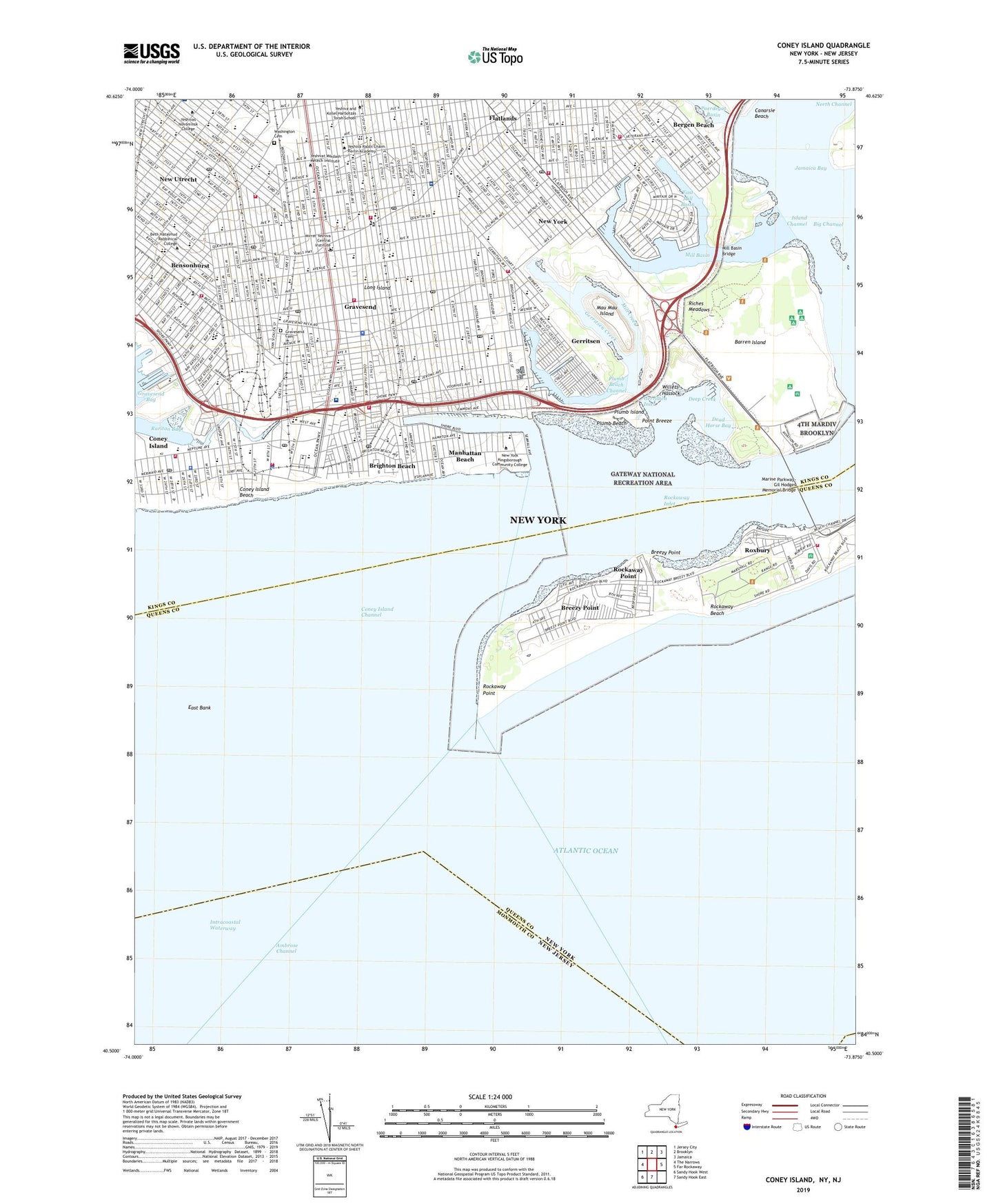
2023 topographic map quadrangle Coney Island in the state of New York. Scale: 1:24000. Based on the newly updated USGS 7.5' US Topo map series, this map is in the following counties: Kings, Queens, Monmouth. The map contains contour data, water features, and other items you are used to seeing on USGS maps, but also has updated roads and other features. This is the next generation of topographic maps. Printed on high-quality waterproof paper with UV fade-resistant inks.
Quads adjacent to this one:
West: The Narrows
Northwest: Jersey City
North: Brooklyn
Northeast: Jamaica
East: Far Rockaway
South: Sandy Hook East
Southwest: Sandy Hook West
This map covers the same area as the classic USGS quad with code o40073e8.
Contains the following named places: Abraham Lincoln High School, Ahaba Ve Ahva Yeshiva, Aimee Triangle, Alexanders Brooklyn Heliport, Andries Playground, Astroland, Avenue T Sub-Station New York City Transit System, Avenue V Sewage Pumping Station, Aviator Sports and Events Center, Bais Yaakov Academy, Barkai Yeshiva, Barren Island, Be'er Mordechai Elementary School, Bensonhurst, Bergen Beach, Bergen Beach Playground, Bergen Beach Yacht Club, Bet Yaakov Ateret Torah, Bet Yakov Ateret Torah High School, Beth Israel Medical Center - Kings Highway Division, Big Apple Education Center, Bill Brown Memorial Playground, Bill Brown Square, Bishop Kearney School, Bnos Israel of East Flatbush, B'Not Rachel High School for Girls, Breezy Point, Brighton Beach, Brighton Beach Park, Brighton Playground, Brooklyn Amity School, Brooklyn Coast Guard Air Station, Brooklyn Hebrew Hospital For The Aged, Brooklyn Marine Park, Brooklyn Studio School, Brooklyn Yacht Club, Calvert Vaux Park, Catherine Laboure Special Education Program, Century Playground, Coast Guard Air Station Brooklyn, Colonel David Marcus Memorial Playground, Commander Eugene S Sarsfield Playground, Coney Island, Coney Island Beach, Coney Island Channel, Coney Island Creek, Coney Island Hospital, Coney Island Terminal New York City Transit System, Corporal Wiltshire Triangle, Cosmo Barone Triangle, Crown Heights Yeshiva, Cutinella Triangle, Dahill Triangle, Dead Horse Bay, Deep Creek, Dock Number 1, Dock Number 10, Dock Number 2, Dock Number 3, Dock Number 4, Dock Number 5, Dock Number 6, Dock Number 7, Dock Number 8, Dock Number 9, Dreamland, East Bank, East Mill Basin, Edward R Murrow High School, Flatlands, Floyd Bennett Field, Fort Tilden, Franklin Delano Roosevelt High School, Fraser Square, Friends Field, Galapo Playground, Garibaldi Square, Gateway National Recreation Area, Georgetown, Gerald H Chambers Square, Gerritsen, Gerritsen Creek, Gerritsen Inlet, Gesher Yehuda, Good Shepherd School, Grady Playground, Gravesend, Gravesend Cemetery, Gravesend Health Sub-Station, Gravesend Park, Gravesend Square, Happyland Manhattan Beach Day School, Herman Dolgon Playground, Hickman Playground, Homecrest Playground, Ida G Israel Community Health Center, Intermediate School 14, Intermediate School 227, Intermediate School 228, Intermediate School 234, Intermediate School 239, Intermediate School 240, Intermediate School 278, Intermediate School 303, Intermediate School 78, Intermediate School 96, Island Channel, James Madison High School, Junior High School 43, Kelly Memorial Playground, Keshaechquereren, KeySpan Park, Kingsborough Community College, Lady Moody Triangle, Lafayette High School, Lafayette Playground, Lawson Institute Home For The Aged And Hospital, Lindower Park, Long Pol Bar, Luna Shopping Center, Manhattan Beach, Manhattan Beach Coast Guard Training Station, Manhattan Beach Park, Marine Park Golf Course, Marine Parkway-Gil Hodges Memorial Bridge, Marlboro Playground, Mau Mau Island, McDonald Playground, Mcguire Fields, Mellett Playground, Meucci Square, Milestone Park, Mill Basin, Mill Basin Bridge, Mill Creek, Monsignor Crawford Field, Naval Air Station New York, New Utrecht, New York Community Hospital, Our Lady of Grace School, Paul W Kolbert Park, Plumb Beach, Plumb Beach Channel, Plumb Island, Point Breeze, Power Playground, Private First Class Thomas Norton Memorial Playground, Private Sealanes-Jamaica Bay Seaplane Base, Public School 100, Public School 101, Public School 121, Public School 128, Public School 153, Public School 177, Public School 186, Public School 193, Public School 194, Public School 195, Public School 197, Public School 199, Public School 203, Public School 205, Public School 206, Public School 207, Public School 209, Public School 212, Public School 215, Public School 216, Public School 222, Public School 226, Public School 236, Public School 238, Public School 247, Public School 248, Public School 253, Public School 254, Public School 255, Public School 277, Public School 286, Public School 312, Public School 370, Public School 48, Public School 52, Public School 80, Public School 95, Public School 97, Public School 98, Public School 99, Public School K225 Eileen E Zaglin, Rachel Haber Cohen Playground, Resurrection School, Riches Meadows, Rockaway Inlet, Rockaway Point, Rockaway Point Yacht Club, Roxbury, Saint Bernard School, Saint Brendans School, Saint Edmund Preparatory High School, Saint Mark School, Saint Thomas Aquinas School, Saints Simon and Jude School, Samuel Goldberg Triangle, Scarangella Park, Seaside Park, Sergeant Joyce Kilmer Triangle, Seth Low Playground, Sheepshead Bay, Sheepshead Bay High School, Sheepshead Playground, Sheepshead Sub-Station New York Transit System, Shell Bank Creek, Sid Luckman Field, Sixteen Trees Triangle, Southwestern Brooklyn Incinerator Department of Sanitation, Steeplechase Pier, Trump Village Shopping Center, Trust Triangle, Washington Cemetery, West Brighton, West Eighth Street Station, West Playground, Willets Hassock, William E Grady High School, WKRB-FM (Brooklyn), Yak Playground, ZIP Codes: 11204, 11214, 11223, 11224, 11229, 11230, 11234, 11235, 11697