MyTopo
Edgewood New Mexico US Topo Map
Couldn't load pickup availability
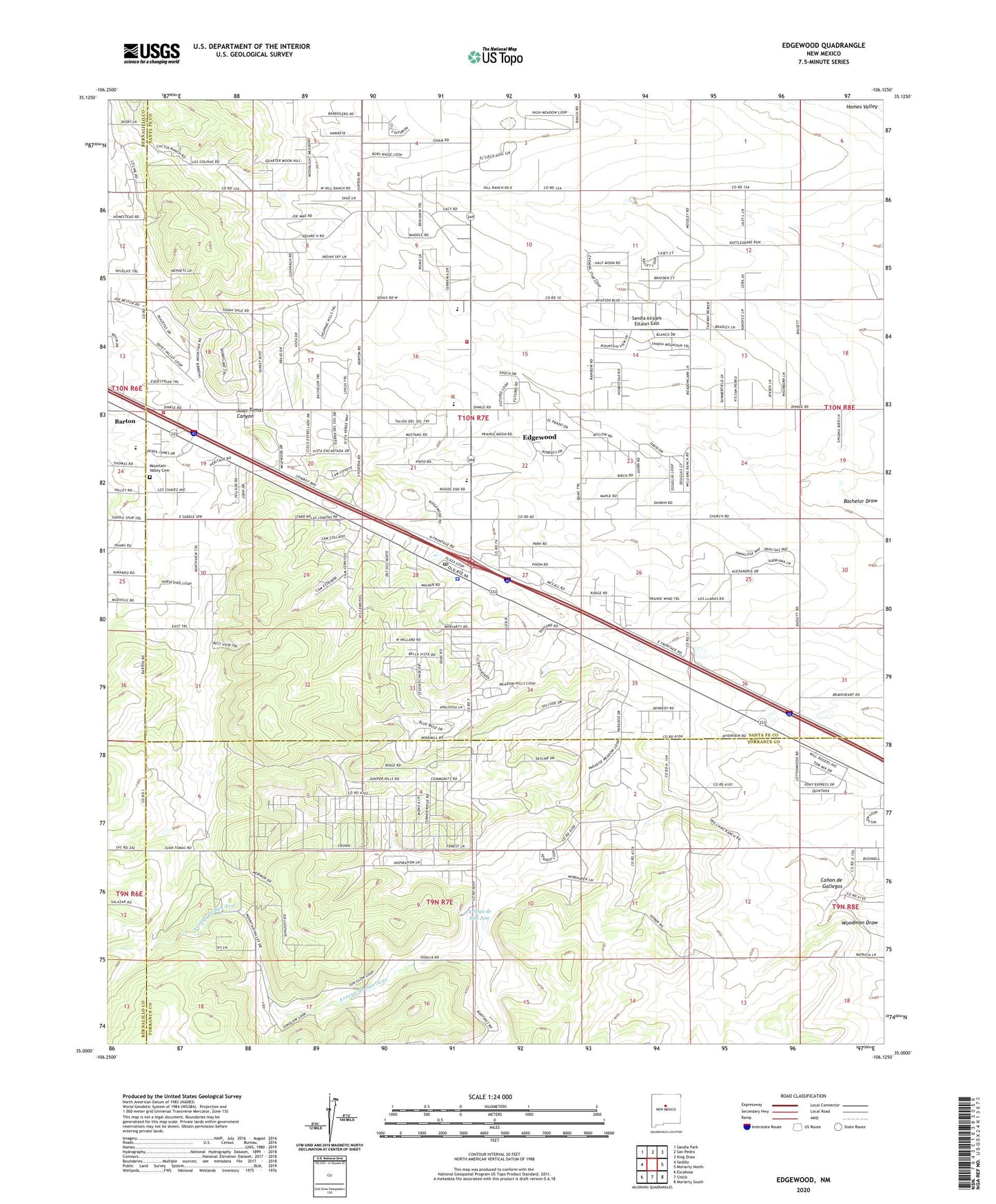
2020 topographic map quadrangle Edgewood in the state of New Mexico. Scale: 1:24000. Based on the newly updated USGS 7.5' US Topo map series, this map is in the following counties: Santa Fe, Torrance, Bernalillo. The map contains contour data, water features, and other items you are used to seeing on USGS maps, but also has updated roads and other features. This is the next generation of topographic maps. Printed on high-quality waterproof paper with UV fade-resistant inks.
Quads adjacent to this one:
West: Sedillo
Northwest: Sandia Park
North: San Pedro
Northeast: King Draw
East: Moriarty North
Southeast: Moriarty South
South: Chilili
Southwest: Escabosa
Contains the following named places: 100613224 Water Well, 10064 Water Well, 110724121 Water Well, 253 Water Well, 451 Water Well, 454 Water Well, 457 Water Well, 458 Water Well, 459 Water Well, 460 Water Well, 461 Water Well, 463 Water Well, 465 Water Well, 466 Water Well, 473 Water Well, 474 Water Well, 535 Water Well, 87015, Arroyo de San Jose, Barton, Barton Post Office, Bassett Ranch, Bella Vista Ranch, Blackwell Place, Briggs Place, Butler Ranch, Canon de Gallegos, Christ Unity at the Edge of the Woods, E-1175 Water Well, E1723-S-2 Water Well, E-2291 Water Well, E-2772 Water Well, E-2779 Water Well, E-286-S Water Well, E-3042 Water Well, E-3493 Water Well, E-3522 Water Well, E-3806 Water Well, E-3909 Water Well, E-483 Water Well, E-761 Water Well, E-761-S-2 Water Well, East Mountain Assembly of God Church, Edgewood, Edgewood Believers Fellowship Church, Edgewood Christian School, Edgewood Elementary School, Edgewood Post Office, Gallegos, Grace Baptist Church, H S Williams Ranch, Hale Ranch, Hill Ranch, Jarett Place, Jarett Place Census Designated Place, Juan Tomas Canyon, La Don Mine, Lacy Place, Learning Institute, Loyd Ranch, McClendon, Moriarty Elementary School, Moriarty High School, Moriarty Middle School, Mosley Place, Mountain Valley Cemetery, Mountainview Elementary School, New Mexico Soaring Ranch Airport, New Mexico State Police District 5 Edgewood, Sandia Airpark Estates East, Santa Fe County Volunteer Fire Edgewood District Station 1, Santa Fe County Volunteer Fire Edgewood District Station 4, Santa Fe County Volunteer Fire Mountain Hills Station, Schockley, Silvia Ranch, Thunder Mountain, Thunder Mountain Census Designated Place, Tina, Tina Barite Deposit, Valley View Christian Church, Water Well 10000, WL Williams Ranch, YMCA Camp