MyTopo
Ruidoso New Mexico US Topo Map
Couldn't load pickup availability
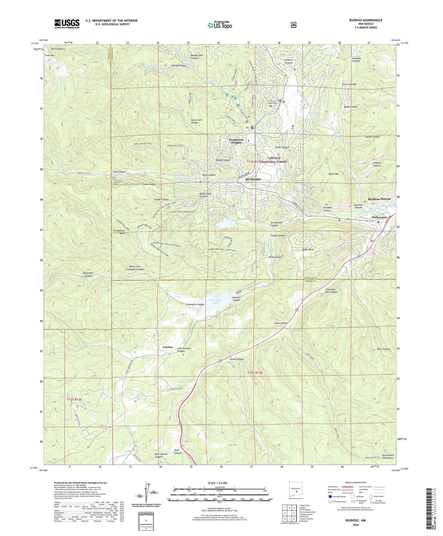
2020 topographic map quadrangle Ruidoso in the state of New Mexico. Scale: 1:24000. Based on the newly updated USGS 7.5' US Topo map series, this map is in the following counties: Otero, Lincoln. The map contains contour data, water features, and other items you are used to seeing on USGS maps, but also has updated roads and other features. This is the next generation of topographic maps. Printed on high-quality waterproof paper with UV fade-resistant inks.
Quads adjacent to this one:
West: Sierra Blanca Peak
Northwest: Nogal Peak
North: Angus
Northeast: Fort Stanton
East: Ruidoso Downs
Southeast: Whitetail
South: Apache Summit
Southwest: Mescalero
Contains the following named places: Airplane Canyon, Alfred Hale Canyon, Alpine Cellars Village, Angus Church of the Nazarene, Bear Canyon, Blazer Mill Historical Marker, Bog Spring, Bogg Canyon, Brady Canyon, Burkes Good News Ministries Church, Carrizo, Carrizo Creek, Cedar Canyon, Cedar Creek, Cedar Creek Campground, Cedar Creek Picnic Area, Cellars Canyon, Cherokee Bill Canyon, Church of Christ, Cienegita Canyon, Community United Methodist Church, Cow Canyon, Cow Mountain, Cree Meadows, Dark Canyon, Dude Mesa, Eastern New Mexico University - Ruidoso Campus, Episcopal Church of the Holy Mount, Fence Canyon, First Assembly of God Church, First Baptist Church, First Christian Church, First Presbyterian Church, Flume Canyon, Flume Ridge, Forest Lawn Cemetery, Gateway Assembly of God Church, Gateway Church of Christ, Gavilan Canyon, Gavilan Memorial Gardens Cemetery, Graham Mine, Grindstone Canyon, Grindstone Mesa, Grown of Life Community Church, Hollywood, Hollywood Post Office, Indian Canyon, Inn of the Mountain Gods, Jim Strong Pit, Jose Second Canyon, Jose Second Dam Number 1, Jose Second Dam Number 2, Jose Second Dam Number 3, KBUY-AM (Ruidoso), KRRR Radio Tower (Conway), Lake Mescalero Dam, Lincoln County Emergency Medical Services Headquarters, Lincoln County Medical Center, Lincoln County Sheriff's Office, Lookout Canyon, Mescalero Apache Fire Rescue Station 2, Mescalero Baptist Mission, Mescalero Lake, Middle Fork Cedar Creek, Mine Canyon, Miserable Canyon, Montessoris Little Red School House, Moon Mountain, Musket Ball Canyon, New Mexico State Police District 8 Rudidoso, Nob Hill Elementary School, North Fork Canyon, North Fork Cedar Creek, North Fork Cienegita Canyon, North Fork Rio Ruidoso, Palmer Tank, Panther Creek, Paradise Canyon, Peace Chapel Universal Life Church, Pentecostal Lighthouse of Ruidoso, Perk Canyon, Perk Ridge Trail, Pete Gaines Canyon, Pidgeon Tank, Pierce Canyon, Ponderosa Heights, Ruidoso, Ruidoso Fire Department Station 1 Headquarters, Ruidoso Fire Department Station 2, Ruidoso Fire Department Station 3, Ruidoso Heliport, Ruidoso High School, Ruidoso Historical Marker, Ruidoso Lookout Tower, Ruidoso Middle School, Ruidoso Municipal Airport, Ruidoso Police Department, Ruidoso Post Office, Ruidoso Weather Station, Saint Eleanors Catholic Church, Salt Well, Sawmill Canyon, Sego Dam, Sheperd of the Hills Lutheran Church, Skunk Canyon, Smokey Bear Ranger Station, Snow Canyon, Snow Spring, South Fork Cedar Creek, South Fork Rio Ruidoso, Spirit of Life Apostolic/Pentecostal Tabernacle, Spring Canyon, The Church of Jesus Christ of Latter Day Saints, Trinity Mountain Fellowship, Village of Ruidoso, White Mountain Elementary School, White Mountain Intermediate School, Wizards Roost, ZIP Codes: 88345, 88355