MyTopo
Canandaigua New York US Topo Map
Couldn't load pickup availability
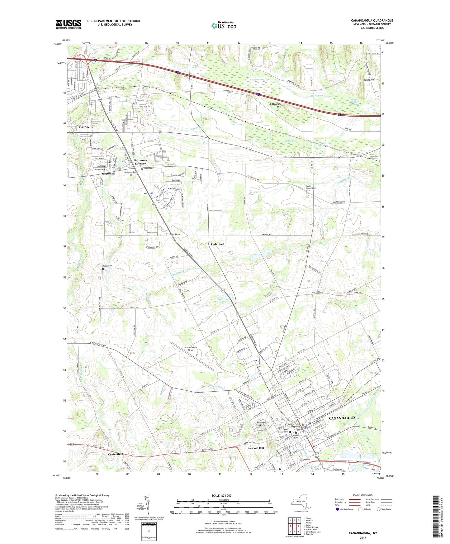
2023 topographic map quadrangle Canandaigua in the state of New York. Scale: 1:24000. Based on the newly updated USGS 7.5' US Topo map series, this map is in the following counties: Ontario. The map contains contour data, water features, and other items you are used to seeing on USGS maps, but also has updated roads and other features. This is the next generation of topographic maps. Printed on high-quality waterproof paper with UV fade-resistant inks.
Quads adjacent to this one:
West: Victor
Northwest: Fairport
North: Macedon
Northeast: Palmyra
East: Clifton Springs
Southeast: Rushville
South: Canandaigua Lake
Southwest: Bristol Center
This map covers the same area as the classic USGS quad with code o42077h3.
Contains the following named places: Arsenal Hill, Beaver Creek, Beaver Meadow Swamp, Black Brook Farm, Black Creek, Blacksmith Corners, Buttermilk Hill, Calvary Assembly of God, Calvary Cemetery, Calvary Chapel Christian School, Canadaigua Veterans Affairs Medical Center, Canandaigua Academy, Canandaigua Airport, Canandaigua Baptist Church, Canandaigua City Hall, Canandaigua Country Estate Mobile Home Park, Canandaigua Elementary School, Canandaigua Emergency Squad, Canandaigua Fire Department, Canandaigua Middle School, Canandaigua Montessori School, Canandaigua Police Department, Canandaigua Post Office, Canandaigua Primary School, Canandaigua Toll Plaza, Center Pointe Golf and Country Club, Centerfield, City of Canandaigua, Clark Manor House Adult Care Facility, Elijah House Adult Care Facility, Elm Manor Nursing Home, Farmington, Farmington Fire Department, Farmington Post Office, Federated Church, FF Thompson Hospital, First Church of Christ Scientist, First Congregational Church, First United Methodist Church, Four Winds Corners, Frederick F Thompson Memorial Hospital, Fresh-Ayr Farm, Good Shepherd Lutheran Church, Hallenbeck Building, Hathaway Cemetery, Hathaway Corners, Hozzey Swamp, Hunt's Mobile Home Park, Ingleside Corners, Mayflower's Nursery And Garden Center, McMiller Corners, Mertensia, New York State Police Troop E Headquarters, Ontario County Court House, Ontario County Sheriff's Office, Padelford, Pioneer Cemetery, Power Cemetery, R And R Farms, Saint Brendan's Christian Fellowship, Saint John's Episcopal Church, Saint Mary's Convent, Saint Mary's Parochial School, Saint Mary's Roman Catholic Church, Sand Hill Cemetery, School Number 1, School Number 10, School Number 11, School Number 8, South Farmington Cemetery, South Farmington Chapel, Tilton Cemetery, Town of Farmington, Troop E Heliport, Unitarian Universalist Church, United Presbyterian Church, WCGR-AM (Canandaigua), Wesleyan Methodist Church, West Avenue Cemetery, Winged Pheasant Golf Club, Wood Library, Woodlawn Cemetery, Woodlawn Court Mobile Home Park, Young Hill, Zion Fellowship, ZIP Code: 14425