MyTopo
Far Rockaway New York US Topo Map
Couldn't load pickup availability
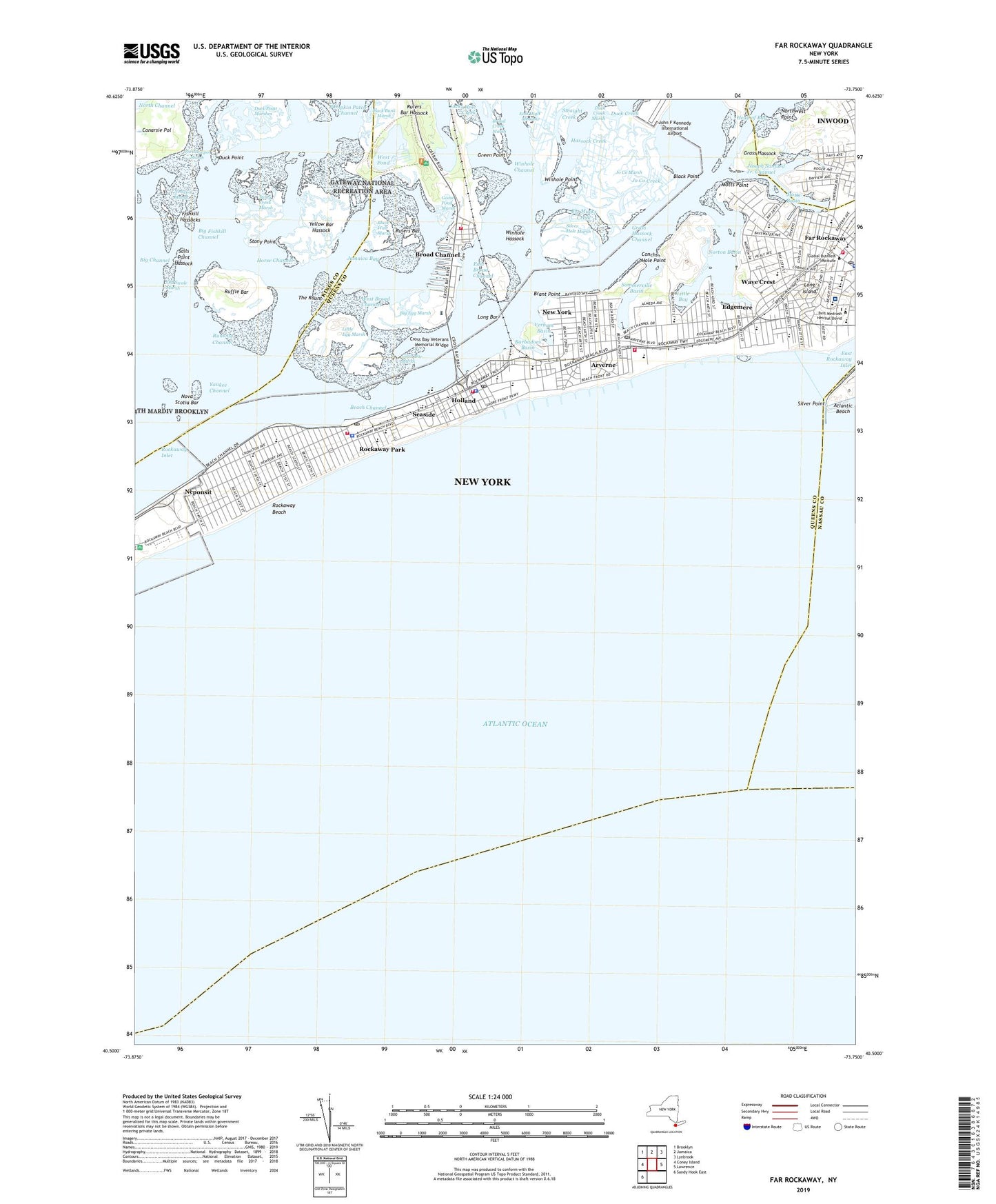
2023 topographic map quadrangle Far Rockaway in the state of New York. Scale: 1:24000. Based on the newly updated USGS 7.5' US Topo map series, this map is in the following counties: Queens, Kings, Nassau. The map contains contour data, water features, and other items you are used to seeing on USGS maps, but also has updated roads and other features. This is the next generation of topographic maps. Printed on high-quality waterproof paper with UV fade-resistant inks.
Quads adjacent to this one:
West: Coney Island
Northwest: Brooklyn
North: Jamaica
Northeast: Lynbrook
East: Lawrence
Southwest: Sandy Hook East
This map covers the same area as the classic USGS quad with code o40073e7.
Contains the following named places: Almeda Playground, Arverne, Arverne Incinerator, Arverne Playground, Arverne Post Office, Arverne Station, Barbadoes Basin, Bass Channel, Bass Channel Island, Bayside Playground, Bayswater, Bayswater Jewish Center, Beach 17th Street Playground, Beach 59th Street Playground, Beach Channel, Beach Channel Playground, Belle Harbor, Benjamin Cardozo Playground, Bethel Temple Church of God, Big Channel, Big Egg Marsh, Big Fishkill Channel, Big Mucks Creek, Black Bank Marsh, Black Point, Black Wall Marsh, Brant Point, Brant Point Wildlife Sanctuary, Broad Channel, Broad Channel Community Park, Broad Channel Park, Broad Channel Volunteer Fire Department and Ambulance Corp, Brood Channel Station, Canarsie Pol, Christian Training and Recreation School, Christianpol Marsh, Church of God Christian Academy, Columbia Theater, Conch Playground, Conchs Hole Point, Congregation Derech Emunah, Congregation Ohav Zedek, Cross Bay Veterans Memorial Bridge, Dubois Point Wildlife Sanctuary, Duck Creek, Duck Creek Marsh, Duck Point, Duck Point Marshes, East Broad Channel, East High Meadow, East Rockaway Inlet, Edgemere, Edgemere Station, Edgemere Urban Renewal Park, Far Rockaway, Far Rockaway Branch Queens Borough Public Library, Far Rockaway Post Office, Far Rockaway Power Station, Far Rockaway Station, Fire Department New York Engine 265 Ladder 121, First Baptist Church, First Church of God, First Congregational Church, Fishkill Hassocks, Frederick Douglas Academy VI High School, Gene Gray Playground, Giant Bar Marsh, Goose Pond Marsh, Grass Hassock, Grass Hassock Channel, Grassmere Playground, Green Point, Gwirtzman Triangle, Hammel, Hammel Playground, Hammels Station, Hassock Creek, Holland, Holland Station, Horse Channel, Incinerator Number 5, Inwood Census Designated Place, Inwood Country Club, Inwood Park, Jacks Hole Creek, Jacob Riis Park, Jamaica Bay, Jamaica Bay Wildlife Refuge, Jewish Community Center of Inwood, Jewish War Veterans Memorial Square, Jo Co Creek, Jo Co Marsh, Joseph Sanford Jr. Channel, Little Bay, Little Bay Marsh, Little Egg Marsh, Long Bar, Merkaz Hatorah of Belle Harbor, Michaelis-Bayswater Park, Middle School 180, Middle School 198, Motts Basin, Motts Point, MS 323 - Region 5 Scholars Academy, Naval Air Station Rockaway, Neponsit, Nestepol Marsh, New York City Fire Department Engine 266 Battalion 47, New York Engine Company 328, New York Fire Department Engine 268 Ladder 137, New York Fire Department Engines 264 and 328 Ladder 134, New York Ladder Company 121, New York Ladder Company 134, New York Ladder Company 137, New York Police Department 100th Precinct Station, New York Police Department 101st Precinct Station, New York Police Department Transit Bureau District 23 Station, Northwest Point, Norton Basin, Nova Scotia Bar, Old Swale Marsh, Patricia A Brackley Park, Patrick S Gilmore School, Peninsula Hospital Center, Peninsula Hospital Center Heliport, Pix Theater, Public School 104, Public School 105, Public School 106, Public School 114, Public School 183, Public School 215, Public School 225, Public School 42, Public School 43, Public School 47, Pumpkin Patch Channel, Q465 Far Rockaway High School, Refuge Church of Christ, Rockaway Airport, Rockaway Beach, Rockaway Beach Post Office, Rockaway Community Park, Rockaway Industrial Park, Rockaway Park, Rockaway Park Post Office, Rockaway Park Station, Rockaway Playland, Ruffle Bar, Rulers Bar, Rulers Bar Hassock, Runway Channel, Sails Point Hassock, Saint Camillus Church, Saint Camillus School, Saint Francis De Sales Church, Saint Francis De Sales School, Saint Gertrude's Church, Saint John's Baptist Church, Saint John's Episcopal Church, Saint John's Episcopal Hospital, Saint Josephs School, Saint Mary's Star of the Sea School, Saint Rose of Lima Church, Saint Rose of Lima School, Saint Virgilius Roman Catholic Church, Saint Virgilius School, Seaside, Seaside Playground, Seaside Station, Silver Hole Marsh, Silver Point, Solid Rock Seventh Day Adventist Church, Somerville, Sommerville Basin, Stella Maris High School, Stony Creek Marsh, Stony Point, Straight Creek, Talmud Torah Siach Yitzchok, Temple of Israel, Terrapeninsula Preserve, The Raunt, The Raunt Station, The Raut, Vernam Basin, Veteran's Circle, Veterans Park, Wave Crest, Wave Crest Station, West Broad Channel, West End Temple, West Pond, Westbourne Playground, Winhole Channel, Winhole Hassock, Winhole Point, Yankee Channel, Yellow Bar Hassock, Yeshiva Darchei Torah, Yeshiva of Belle Harbor, ZIP Codes: 11096, 11691, 11692, 11693, 11694