MyTopo
Groton New York US Topo Map
Couldn't load pickup availability
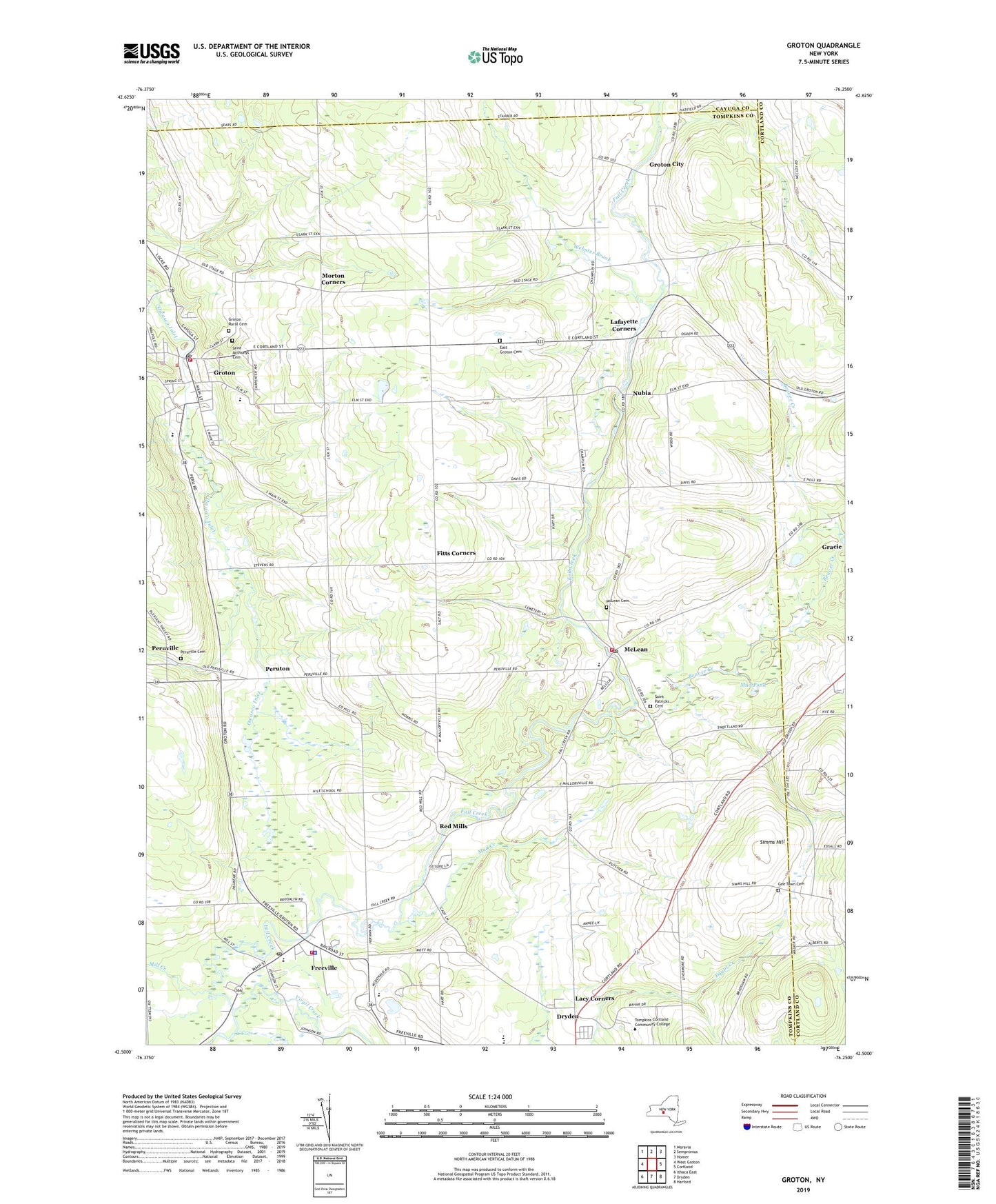
2023 topographic map quadrangle Groton in the state of New York. Scale: 1:24000. Based on the newly updated USGS 7.5' US Topo map series, this map is in the following counties: Tompkins, Cortland, Cayuga. The map contains contour data, water features, and other items you are used to seeing on USGS maps, but also has updated roads and other features. This is the next generation of topographic maps. Printed on high-quality waterproof paper with UV fade-resistant inks.
Quads adjacent to this one:
West: West Groton
Northwest: Moravia
North: Sempronius
Northeast: Homer
East: Cortland
Southeast: Harford
South: Dryden
Southwest: Ithaca East
This map covers the same area as the classic USGS quad with code o42076e3.
Contains the following named places: Ballard Corners, Beaver Creek, Carey Corners, Carroll Farms, Cassavant Elementary School, Chflocie Farms, Cortland National Fish Hatchery, Country Acres Mobile Home Park, Dryden High School, Dryden Middle School, East Groton Cemetery, Elm Tree Golf Course, Fitts Corners, Fouts Farm, Freeville, Freeville Elementary School, Freeville Fire Department, Freeville Post Office, Freeville Village Wastewater Treatment Plant, Gee Town Cemetery, George Junior Republic High School, Groton, Groton Assembly of God Church, Groton City, Groton City United Church of Christ, Groton Community Church, Groton Community Health Care Center Residential Care Facility, Groton Elementary School, Groton Fire Department, Groton High School, Groton Middle School, Groton Post Office, Groton Public Library, Groton Rural Cemetery, Groton Village Sewage Treatment Plant, Hard Times Hog Farm, Hart Corners, Heritage Baptist Church, Jaslin Court Mobile Home Park, Jones Corners, Kingdom Hall of Jehovah's Witnesses, Lacy Corners, Lafayette Corners, Malloryville, Mc Lean Post Office, McCloy Farm, McLean, McLean Cemetery, McLean Census Designated Place, McLean Community Church, McLean Fire Department, Merchants Corners, Mill Creek, Mill Dam Park, Morton Corners, Mud Creek, Mud Pond, Mud Schoolhouse Corners, Nubia, Peruton, Peruville, Peruville Cemetery, Pleasant Valley, Red Mills, Riggs Corners, Saint Anthony's Catholic Church, Saint Anthonys Cemetery, Saint Patricks Cemetery, School Number 1, School Number 10, School Number 11, School Number 13, School Number 14, School Number 16, School Number 17, School Number 19, School Number 27, School Number 3, School Number 4, School Number 5, School Number 6, School Number 9, Simms Hill, Stevens Corners, Stone Hedges Country Club, Sugar Bush Farms, Tompkins Cortland Community College, Town of Groton, Valhalla Farm, Victory Christian Academy, Village of Freeville, Village of Groton, Virgil Creek, Webster Brook, ZIP Code: 13102