MyTopo
Horseheads New York US Topo Map
Couldn't load pickup availability
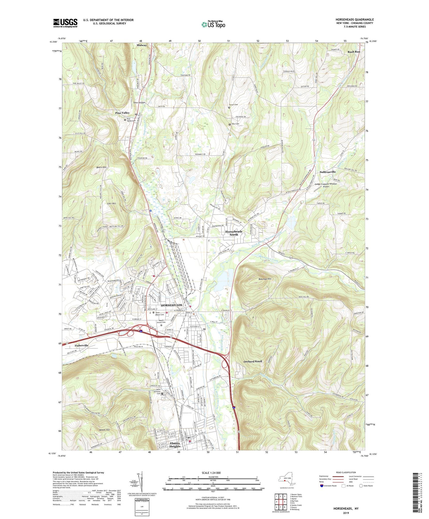
2023 topographic map quadrangle Horseheads in the state of New York. Scale: 1:24000. Based on the newly updated USGS 7.5' US Topo map series, this map is in the following counties: Chemung. The map contains contour data, water features, and other items you are used to seeing on USGS maps, but also has updated roads and other features. This is the next generation of topographic maps. Printed on high-quality waterproof paper with UV fade-resistant inks.
Quads adjacent to this one:
West: Big Flats
Northwest: Beaver Dams
North: Montour Falls
Northeast: Alpine
East: Erin
Southeast: Wellsburg
South: Elmira
Southwest: Seeley Creek
This map covers the same area as the classic USGS quad with code o42076b7.
Contains the following named places: Arnot Mall Shopping Center, Baileys Creek, Beaver Brook, Beers Hill, Bethany Nursing Home and Health Related Facility, Bethany Retirement Home, Bible Baptist Church, Bowman Hill, Broad Street School, Bulkley Creek, Calvary Baptist Church, Carr Hill, Center Street School, Central Assembly of God, Chemung County, Church of Christ, Cohen School, Dodge/Coppola/Wheeler Airport, Elcor Nursing Home, Elmira Heights, Elmira Heights Fire Department, Elmira Heights Police Department, Elmira Heights Post Office, Elmira Heights Senior Citizens Day Center, Elmira Heights Village Hall, Elmwood Avenue Baptist Church, Faith Tabernacle Evangelical Church, First Baptist Church of Horseheads, First Presbyterian Church of Horseheads, First United Methodist Church of Horseheads, Fisherville, Gardner Road Elementary School, Glad Tidings Christian Life Church, Glad Tydings Church, Grace Church of the Nazarene, Hawes Hill, Horseheads, Horseheads Armory, Horseheads Fire Department, Horseheads Free Library, Horseheads Intermediate School, Horseheads Middle School, Horseheads North Census Designated Place, Horseheads Post Office, Horseheads Senior High School, Horseheads Town Hall, Horseheads Village Hall, Latta Brook, Lenox Avenue School, Lincoln School, Love Church, Maple Grove Cemetery, Maplehurst Park, Maranatha Bible Chapel, Mark Twain Golf Course, New York State Police Troop E Zone 3 Horseheads Station, North Branch Newtown Creek, Oakwood United Methodist Church, Omni Airpark, Orchard Knoll, Our Saviour's Lutheran Church, Painters Lick, Pine Valley, Pine Valley Cemetery, Pine Valley Census Designated Place, Pine Valley Mobile Home Park, Pine Valley Post Office, Pine Valley United Methodist Church, Pine Wood Campground, Pioneer Village, Ridge Road School, Rolling Acres Mobile Home Park, Rush Run, Saint John's Episcopal Church, Saint Mary our Mother School, Saint Marys Cemetery, Saint Matthew's Episcopal Church, Saint Nicholas Cemetery, Seventh Day Adventist Church, Soaring Eagles Golf Course, Steele Memorial Library, Sullivanville, Sullivanville United Methodist Church, The Church of Jesus Christ of Latter Day Saints, Thurston School, Town and Country Fire Department, Town and Country Volunteer Fire Department Station 2, Town of Horseheads, Town of Veteran, Turner Cemetery, Vary Cemetery, Village of Elmira Heights, Village of Horseheads, WEHH-AM (Elmira Heights-Horseheads), Wesleyan Church, WIQT-AM (Horseheads), WLNL-AM (Horseheads), WLVY-FM (Elmira), WQIX-FM (Horseheads), ZIP Codes: 14845, 14872, 14903