MyTopo
Olean New York US Topo Map
Couldn't load pickup availability
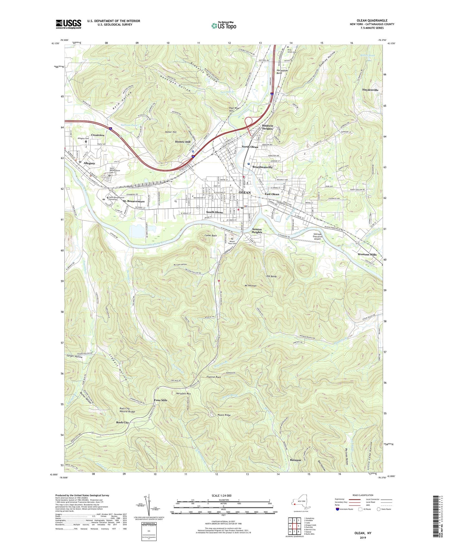
2019 topographic map quadrangle Olean in the state of New York. Scale: 1:24000. Based on the newly updated USGS 7.5' US Topo map series, this map is in the following counties: Cattaraugus. The map contains contour data, water features, and other items you are used to seeing on USGS maps, but also has updated roads and other features. This is the next generation of topographic maps. Printed on high-quality waterproof paper with UV fade-resistant inks.
Quads adjacent to this one:
West: Knapp Creek
Northwest: Humphrey
North: Hinsdale
Northeast: Cuba
East: Portville
Southeast: Bullis Mills
South: Eldred
Southwest: Derrick City
Contains the following named places: Allegany, Allegany Baptist Church, Allegany Cemetery, Allegany Elementary School, Allegany Fire House Number 1, Allegany Full Gospel Church, Allegany Post Office, Allegany Public Library, Allegany Town Hall, Allegany Village Municipal Building, Archbishop Walsh High School, Aspen Tower Assisted Living Center, Baha'i Faith, Baldwin Heights, Barbers Trailer Ranch, Barlett Country Club, Barnum, Bethany Lutheran Church, Bethel Assembly of God Church, Bethel Baptist Church, Blakesly Hollow, B'nai Israel Cemetery, Boardman Park, Boardmanville, Boardmanville Elementary School, Bradner Stadium, Bucher Hollow, Butler Gymnasium, Calvary Baptist Church, Camel Back, Central Baptist Church, Central High School, Christ United Methodist Church, Church of God of Prophecy, Church of the Nazarene, City of Olean, City of Olean Filter Plant and Pumping Station, Clean Center Mall Shopping Center, Congregation B'nai Israel Synagogue, Cornerstone Full Gospel Church, Crestview, Cutco Theater, Damietta Center, DeLaRouche Hall, Depot Square, Devereux Hall, Doyle Hall, Dresser-Rand Training And Conference Center, East Olean, East View Elementary School, Eden Heights of Orlean Assisted Living Center, Egstrom Pond, First Baptist Church, First Church of Christ Scientist, First Methodist Church, First Methodist Episcopal Church, First Presbyterian Church, First Wesleyan Methodist Church, Flatiron Rock, Forness Park, Four Mile, Fourmile Creek, Foursquare Gospel Church, Franchot Field, Francis Hall, Franciscan Friary, Free Methodist Church, Friedsam Memorial Library, Gardens of Brother Leo, Gargoyle Park, Geiger Hollow, Giermek Executive Airport, Glen of Saint Clare, Godfrey Hollow, Grace Alliance Church, Hannigan Hollow, Hartzfelt Mountain, Haskell Creek, Haydenville, Hickey Dining Hall, Hillside Wesleyan Church, Homer Hill, Honey Brook, Hopkins Hall, Horseshoe Bend, Immanuel Evangelical Lutheran Church, Ivers J Norton Elementary School, Jamestown Community College Cattaraugus County Campus, John J Murphy Professional Building, Johnson Hollow, Keim Hollow, Kingdom Hall of Jehovah's Witnesses, Kings Brook, Lampack Poultry Farm, Lincoln Park, Lippert Hollow, Living Waters Church, Mc Cann Hollow, McGraw-Jennings Athletic Fields, Midway Airport, Millers Pond, Moore Ridge, Mount Herman, Mount View Cemetery, Mount Zion Christian Assembly, Mountain Clinic, New Life Christian School, New York State Police Troop A Zone 4 Olean Station, North Hill Elementary School, North Olean, North Olean Yards, Oak Hill Park, Old Baldy, Olean, Olean Armory, Olean Business Institute, Olean Creek, Olean Fire Department, Olean Fire Department Central Station, Olean Fire Department Station 1, Olean General Hospital, Olean Gospel Tabernacle, Olean Industrial Park, Olean Middle School, Olean Municipal Building, Olean Police Department, Olean Post Office, Olean Public Library, Olean Raceway, Olean Rod and Gun Club, Olean Senior High School, Palace Theatre, Paul Wise Hill, People's Methodist Church, Plassmann Hall, Polish Catholic Church of the Transfiguration, Public School Number 8, Regina A Quick Center for the Arts, Reilly Center, River Park Health Care Center, Riverview Park, Robinson/Falconio Halls, Rock City, Rock City Natural Bridge, Rock City Park, Rock of Revelation Church, Sacred Temple, Saint Bonaventure, Saint Bonaventure Cemetery, Saint Bonaventure Census Designated Place, Saint Bonaventure Parochial School, Saint Bonaventure Post Office, Saint Bonaventure Roman Catholic Church, Saint Bonaventure University, Saint Bonaventure University Golf Club, Saint Elizabeth's Academy, Saint Francis Hospital, Saint John's Evangelical Lutheran Church, Saint John's Parochial School, Saint John's Roman Catholic Church, Saint Josephs Manor Home for the Chronically Ill, Saint Joseph's Manor Nursing Home, Saint Joseph's Roman Catholic Church, Saint Josephs School, Saint Marys of the Angels Roman Catholic Church, Saint Stephen's Episcopal Church, Sandra A and William L Richter Center, Savage Hollow, School Number 1, School Number 11, School Number 4, School Number 9, Seminary of Christ the King, Seneca Heights, Seventh Day Adventist Church, Shay/Loughlen Hall, Showers United Methodist Church, South Olean, South Olean Yards, South Side Chapel, Southern Tier Catholic School, The Church of Jesus Christ of Latter Day Saints, Town of Allegany Garage, Town of Olean, Trans Am Ambulance Services, Trinity United Methodist Church, Twomile Creek, United Pentecostal Church, University Chapel, University Ministries Center, University Observatory, Village of Allegany, Village of Saint Anthony, War Veterans Park, Washington West Elementary School, West Branch Fourmile Creek, Westons Mills, WHDL-AM (Olean), WMNS-AM (Olean), WMXO-FM (Olean), WPIG-FM (Olean), WSBU-FM (Saint Bonaventure), ZIP Codes: 14760, 14778, 14788