MyTopo
Spencerport New York US Topo Map
Couldn't load pickup availability
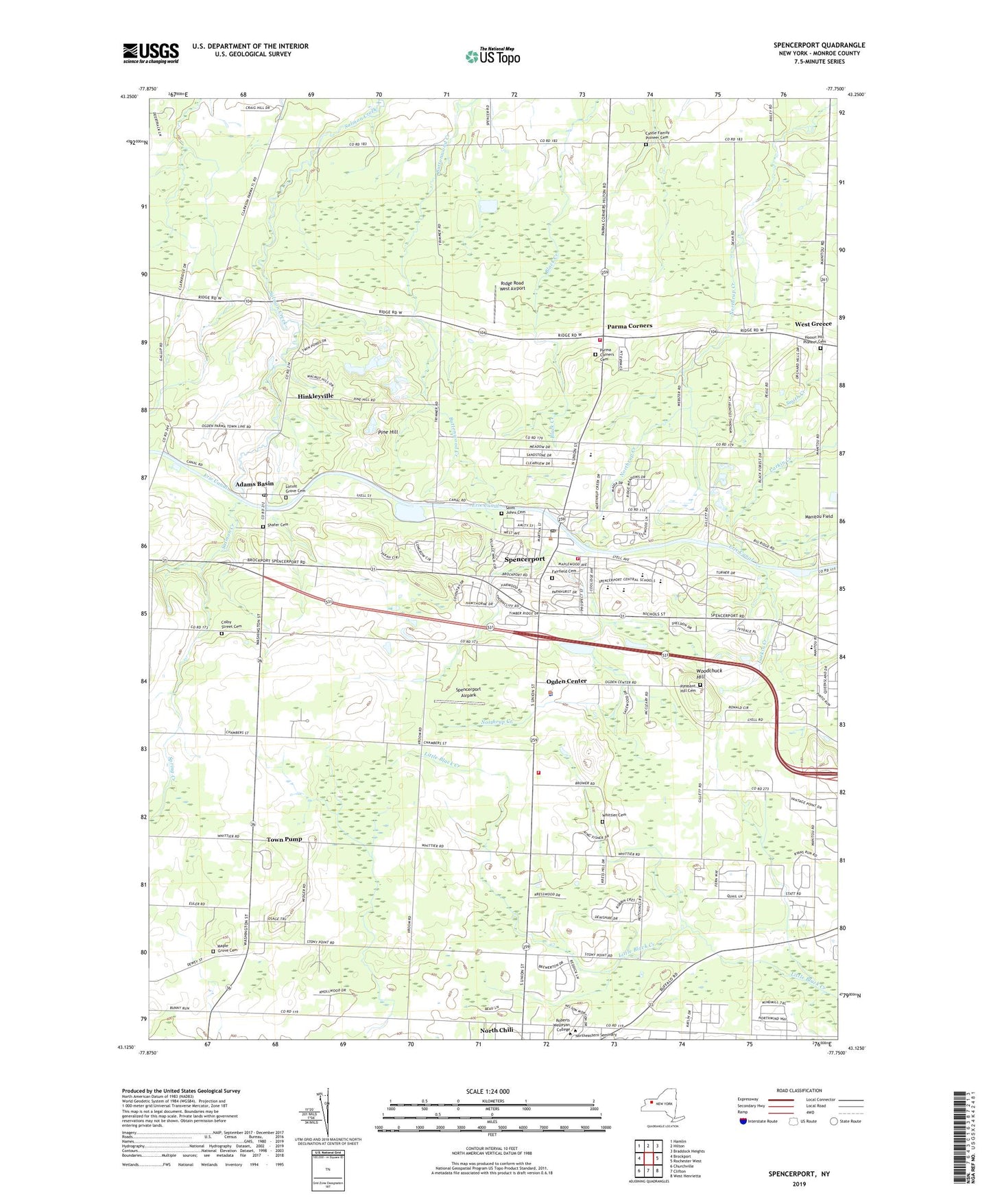
2023 topographic map quadrangle Spencerport in the state of New York. Scale: 1:24000. Based on the newly updated USGS 7.5' US Topo map series, this map is in the following counties: Monroe. The map contains contour data, water features, and other items you are used to seeing on USGS maps, but also has updated roads and other features. This is the next generation of topographic maps. Printed on high-quality waterproof paper with UV fade-resistant inks.
Quads adjacent to this one:
West: Brockport
Northwest: Hamlin
North: Hilton
Northeast: Braddock Heights
East: Rochester West
Southeast: West Henrietta
South: Clifton
Southwest: Churchville
This map covers the same area as the classic USGS quad with code o43077b7.
Contains the following named places: A M Cosgrove Middle School, Adams Basin, Adams Basin Post Office, B Thomas Golisano Library, Braemar Country Club, Bridle Wreath Farm, Buttonwood Golf Course, Canal View Elementary School, Cardinal Creek Country Club, Castle Family Pioneer Cemetery, Catfield, Childtime Childcare Center, Chili Bible Baptist Church, Cobble Creek Farm, Colby Homestead Farms, Colby Street Cemetery, Craig Hill Country Club, Davison Hall, Deconinck Farms, Deerfield Country Club, Fairfield Cemetery, Faith Baptist Church, Fallone's Funtime Center, Garlock Dining Commons, Grace Church of the Nazarene, Hastings Center For Academics, Hinkleyville, Hoosic Hill Pioneer Cemetery, Italian American Community Center, Leibeck Farm, Leo Bernabi Elementary School, Locust Grove Cemetery, Manitou Field, Maple Grove Cemetery, Mariah Meadows Farm, Mersereau Hall, Miner Hall, Ogden Center, Ogden Church, Ogden Community Center, Ogden Farmers Library, Ogden Industrial Isle, Ogden Senior Center, Ogden Town Hall, Parma Corners, Parma Corners Cemetery, Pine Hill, Pinewood Country Club, Pleasant Hill Cemetery, Regency Oaks Industrial Park, Ridge Road West Airport, Rinker Community Service Center, Robbs Farm, Roberts Wesleyan College, Saint John the Evangelist School, Saint Johns Cemetery, Salmon Creek Country Club, School Number 10, School Number 11, School Number 12, School Number 13, School Number 2, School Number 3, School Number 4, School Number 5, School Number 6, School Number 8, September Place Mobile Home Park, Shafer Cemetery, Spencerport, Spencerport Airpark, Spencerport Fire District - Station 1, Spencerport Fire District - Station 3, Spencerport Fire District Station 2, Spencerport High School, Spencerport Post Office, Spencerport Village Hall, Spencerport Volunteer Ambulance Service, Spencerport Wastewater Treatment Plant, Spencerport Waterworks, Spring Creek, Springdale Farm, Sweeney Farms, Town Line School, Town of Ogden, Town Pump, Trowbridge School, Twin Hills Golf Course, United Methodist Church, Vantage Point Business Center, Victory Community Church, Village of Spencerport, Village Plaza Shopping Center, Voller Athletic Center, Wedgewood Nursing Home, West Greece, Westover Center, Whittier Cemetery, Whittier Fruit Farm, William C Munn Elementary School, Willson School, Woodchuck Hill, WRMM-AM (Rochester), Zuber Farms, ZIP Code: 14559