MyTopo
Brockport New York US Topo Map
Couldn't load pickup availability
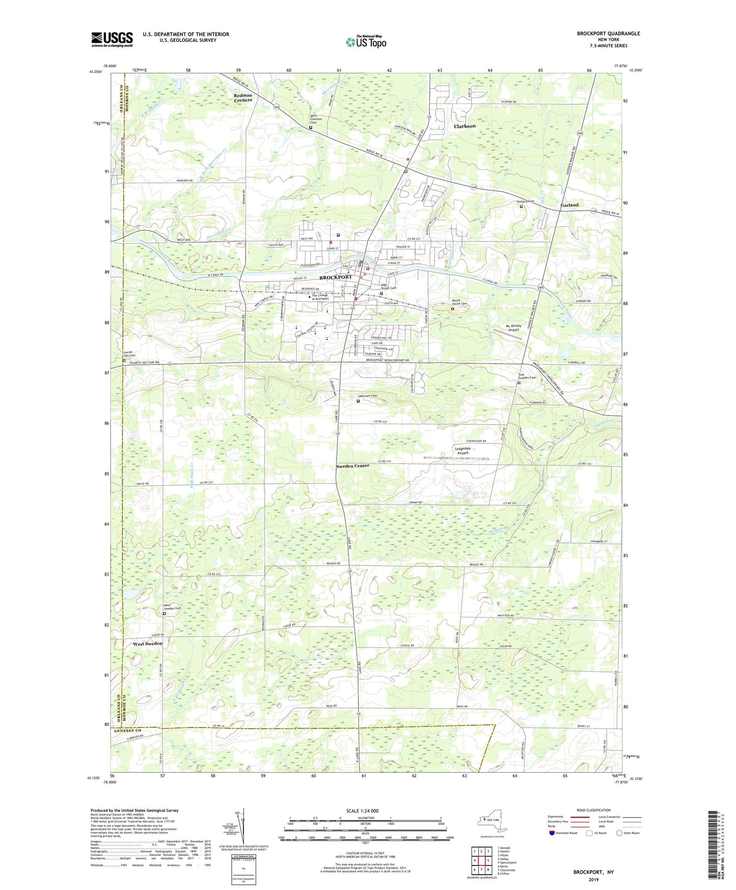
2023 topographic map quadrangle Brockport in the state of New York. Scale: 1:24000. Based on the newly updated USGS 7.5' US Topo map series, this map is in the following counties: Monroe, Genesee, Orleans. The map contains contour data, water features, and other items you are used to seeing on USGS maps, but also has updated roads and other features. This is the next generation of topographic maps. Printed on high-quality waterproof paper with UV fade-resistant inks.
Quads adjacent to this one:
West: Holley
Northwest: Kendall
North: Hamlin
Northeast: Hilton
East: Spencerport
Southeast: Clifton
South: Churchville
Southwest: Byron
This map covers the same area as the classic USGS quad with code o43077b8.
Contains the following named places: A D Oliver Middle School, Albert W Brown Building, Allen Administration Building, Arrowhead Golf Club, Assembly of God Church, Barclay Elementary School, Benedict Hall, Bob Boozer Field, Bramley Hall, Briggs Hall, Brockport, Brockport Child Daycare Center, Brockport Country Club, Brockport Fire Department Station 1, Brockport Fire Department Station 2, Brockport Fire Department Station 3, Brockport Fire Department Station 4, Brockport Free Methodist Church, Brockport Gap Filler Annex, Brockport High School, Brockport Post Office, Brockport United Methodist Church, Brockport Village Hall, Brockport-Seymour Library, Brockway Hall, Cary Memorial Hall, Chapman Service Center, Christ Community Church, Christ Community Church School, Clarkson, Clarkson Census Designated Place, Clarkson Children's Center, Clarkson Congregational Church, Clarkson District Number 2 Public School, Clarkson Mobile Home Park, Clarkson Post Office, Clarkson Town Hall, Concordia Evangelical Lutheran Church, Conrad Welcome Center, Cooper Hall, Cornerstone Christian Academy, Dailey Hall, Dobson Hall, Drake Memorial Library, East Sweden Cemetery, Edwards Hall, First Baptist Church, First Presbyterian Church, Fred W Hill School, Free Methodist Church, Garland, Garland Cemetery, Garland Methodist Church, Ginther Elementary School, God Holy Temple, Gordon Hall, Grace Baptist Church, Greenridge Mobile Home Park, Harmon Hall, Harrison Hall, Hartwell Hall, Hazen Health Center, High Street Cemetery, Holmes Hall, Jubilee Christian Church, Lakeside - Beikirch Care Center, Lakeside Child Care Center, Lakeview Cemetery, Lathrop Hall, Ledgedale Airpark, Lennon Hall, Locust Hill Cemetery, MacVicar Hall, Mc Kinney Airport, McCracken Farms, McFarlane Hall, McLean Hall, Morgan Hall, Mortimer Hall, Mount Olivet Cemetery, Nativity Parochial School, Northampton Park, Perry Hall, Rakov Center For Student Services, Redman Corners, Roman Catholic Church of the Nativity, Saint Luke's Episcopal Church, School Number 1, School Number 14, School Number 4, School Number 5, School Number 6, School Number 7, School Number 8, School Number 9, Seymour College Union, Smith Hall, Special Olympics Stadium, State University of New York College at Brockport, Strand Theatre, Strong Memorial Hospital, Sweden Center, Sweden Community Center, Sweden Senior Center, Sweden Town Hall, The Church of Jesus Christ of Latter Day Saints, The Landing, Thompson Hall, Tower Fine Arts Center, Town of Clarkson Courthouse, Town of Sweden, Town of Sweden Courthouse, Tuttle North Athletic Complex, Tuttle South Gymnasium, Vanderhoof Hall, Village of Brockport, WASB-AM (Brockport), WBKT-FM (Brockport), WBSU-FM (Brockport), West Clarkson Cemetery, West Fork Moorman Creek, West Sweden, West Sweden Cemetery, ZIP Code: 14420