MyTopo
Webster New York US Topo Map
Couldn't load pickup availability
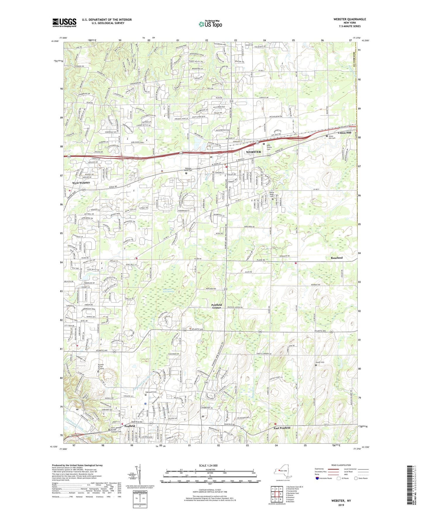
2023 topographic map quadrangle Webster in the state of New York. Scale: 1:24000. Based on the newly updated USGS 7.5' US Topo map series, this map is in the following counties: Monroe, Wayne. The map contains contour data, water features, and other items you are used to seeing on USGS maps, but also has updated roads and other features. This is the next generation of topographic maps. Printed on high-quality waterproof paper with UV fade-resistant inks.
Quads adjacent to this one:
West: Rochester East
Northwest: Rochester East OE N
North: Ninemile Point
Northeast: Furnaceville
East: Ontario
Southeast: Macedon
South: Fairport
Southwest: Pittsford
This map covers the same area as the classic USGS quad with code o43077b4.
Contains the following named places: Aaron Manor Rehabilitation and Nursing Center, Baird Road School, Bay Trail Middle School, Charles G Finney High School, Childtime Children's Center, Church of the Holy Spirit, Church of the Incarnation, Cliffside Common Shopping Center, Cobbles Elementary School, Commission Ditch, Creekedge Farm, Denonville Junior High School, East Penfield, East Penfield Church, Empire Drive-In, Faith Child Care and Nursery School, Faith Church, First Baptist Church, First Methodist Church, First Presbyterian Church, Grande Vie Senior Living Community, Harris Hill Elementary School, Harris Road Cemetery, Holy Trinity Cemetery, Holy Trinity Roman Catholic Church, Holy Trinity School, Klem Road North Elementary School, Klem Road South School, Maplewood Nursing Home, New York State Police Troop E Zone 1 Penfield Station, Oakwood Cemetery, Panorama Plaza Shopping Center, Panorama Post Office, Parkside Commons Shopping Center, Penfield, Penfield Center, Penfield Church, Penfield Community Center, Penfield Country Club, Penfield Fire Company - Station 1, Penfield Fire Company - Station 2, Penfield Fire Company - Station 3, Penfield Place Nursing Home, Penfield Post Office, Penfield Presbyterian Church Daycare Center, Penfield Public Library, Penfield Senior High School, Penfield Town Hall, Penfield Village Nursery School and Kindergarten, Penfield Volunteer Emergency Ambulance Service, Penn Fair Plaza Shopping Center, Pepper Hill Farm Child Care Center, Pioneer Burial Ground, Plank Road North Elementary School, Plank Road South Elementary School, Roseland, Saint Josephs Roman Catholic Cemetery, Saint Josephs School, Saint Pauls Church, Schlegel Road Elementary School, School Number 10, School Number 13, School Number 5, School Number 7, School Number 8, Schutts Farm, Scribner Road Elementary School, Shadow Lake Golf and Raquet Club, Shadow Pines Country Club, Smith Cemetery, Speedy's Plaza Shopping Center, Spry Middle School, State Road Elementary School, Thomas High School, Thousand Acre Brook, Thousand Acre Swamp, Toddlers' Workshop Kindergarten, Tots University Child Care Campus, Town of Penfield, Town of Penfield Courthouse, Town of Webster, Town of Webster Courthouse, Union Hill Cemetery, Union Hill Volunteer Fire Department Station 1, Village of Webster, WBEE-FM (Rochester), Webster, Webster - Schroeder High School, Webster Christian School, Webster Community Center, Webster Golf Course, Webster Montessori School, Webster Museum, Webster Plaza Shopping Center, Webster Post Office, Webster Public Library, Webster Rural Cemetery, Webster Square Shopping Center, Webster Town Hall, Webster Village Hall, Webster Volunteer Fire Department - Station 1 - Enderlin, Webster Volunteer Fire Department Roseland Station 2, Webster Woods Business Park, West Webster, West Webster Volunteer Fire Department Station 1, West Webster Volunteer Fire Department Station 3, Willink Middle School, WMHN-FM (Webster), ZIP Codes: 14526, 14580