MyTopo
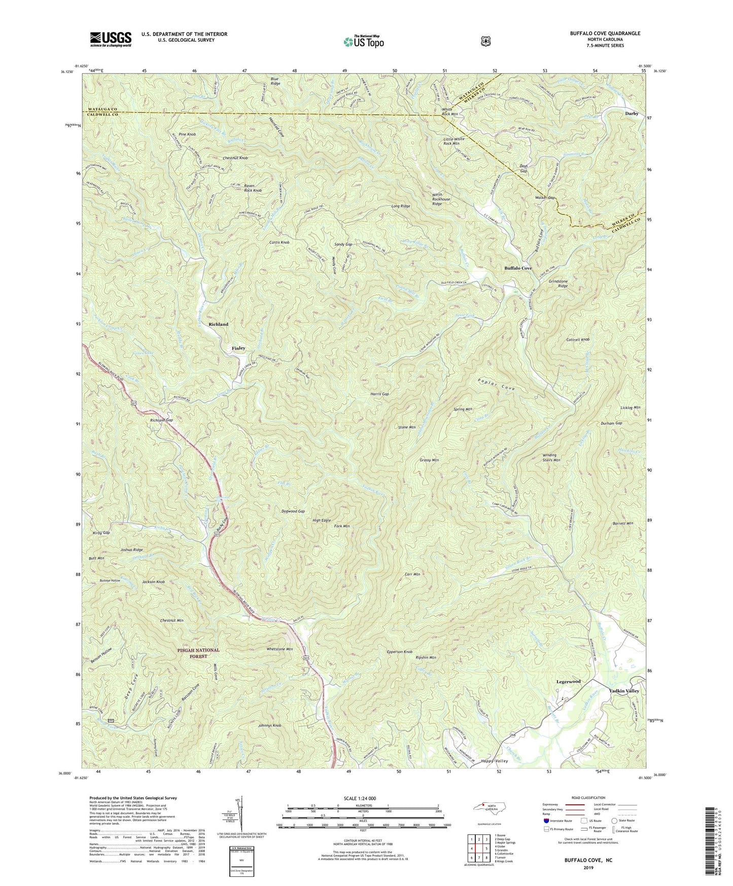
Buffalo Cove North Carolina US Topo Map
Couldn't load pickup availability
Also explore the Buffalo Cove Forest Service Topo of this same quad for updated USFS data
2022 topographic map quadrangle Buffalo Cove in the state of North Carolina. Scale: 1:24000. Based on the newly updated USGS 7.5' US Topo map series, this map is in the following counties: Caldwell, Wilkes, Watauga. The map contains contour data, water features, and other items you are used to seeing on USGS maps, but also has updated roads and other features. This is the next generation of topographic maps. Printed on high-quality waterproof paper with UV fade-resistant inks.
Quads adjacent to this one:
West: Globe
Northwest: Boone
North: Deep Gap
Northeast: Maple Springs
East: Grandin
Southeast: Kings Creek
South: Lenoir
Southwest: Collettsville
This map covers the same area as the classic USGS quad with code o36081a5.
Contains the following named places: A A Rauchfuss Lake, A A Rauchfuss Lake Dam, Addies Branch, Bailey Camp Creek, Barnett Branch, Barrett Mountain, Beacon Hills, Bethany Church, Boone Fork Recreation Site, Bradshaw School, Buffalo Cove, Buffalo Cove Baptist Church, Buffalo Creek, Butt Mountain, Camp Carolwood, Carr Mountain, Chapel of Rest, Chestnut Knob, Chestnut Mountain, Church Branch, Cling Branch, Cloverhill Plantation, Cones Lake, Cook Branch, Corpening Branch, Cottrell Knob, Cove Branch, Curtis Knob, Davenport, Days Gap, Deep Cove, Dennis Creek, Dogwood Gap, Durham Gap, Elk Branch, Epperson Knob, Field Branch, Finley, Flat Branch, Fork Mountain, Grassy Mountain, Green Rock Baptist Church, Green Rock Branch, Green Rock Church, Greenfield Branch, Grindstone Ridge, Happy Valley, Harris Gap, Haunted Cove, Hickory Flat Branch, High Eagle, Hog Camp Branch, Jackson Camp Creek, Jackson Knob, Jesse Fork, Joes Creek, Johnnys Knob, Jones, Joshua Ridge, Kirby Creek, Kirby Gap, Legerwood, Licklog Branch, Licklog Mountain, Little Dugger Creek, Little White Rock Mountain, Long Branch, Long Ridge, Long Ridge Branch, Lowder Mill Branch, Matts Branch, McCloud Branch, Mills Cove, Mine Branch, Moody Cove, Muddy Branch, Nelsons Chapel, North Rockhouse Ridge, Ooten Creek, Orchard Branch, Patterson School, Pegs Branch, Pine Knob, Poplar Cove, Pound Mill Branch, Preston Creek, Puncheon Camp Creek, Raccoon Cove, Raven Rock Knob, Red Rock Creek, Richland, Richland Gap, Ripshin Mountain, Rock Springs Church, Rockhouse Creek, Rocky Cove, Sandy Gap, Sarrett Branch, Silvervale Falls, Simmons Branch, Spanish Oak Branch, Spring Mountain, Stone Mountain, Stone Mountain Branch, Strutton Creek, Tommy Cove, Toms Branch, Township of Patterson, Township of Yadkin Valley, Triplett Creek, Walker Gap, Walnut Branch, Whetstone Mountain, White Rock Mountain, Winding Stairs Mountain, Winters Branch, Wolfpen Creek, Yadkin Valley Church