MyTopo
Bunches Bald North Carolina US Topo Map
Couldn't load pickup availability
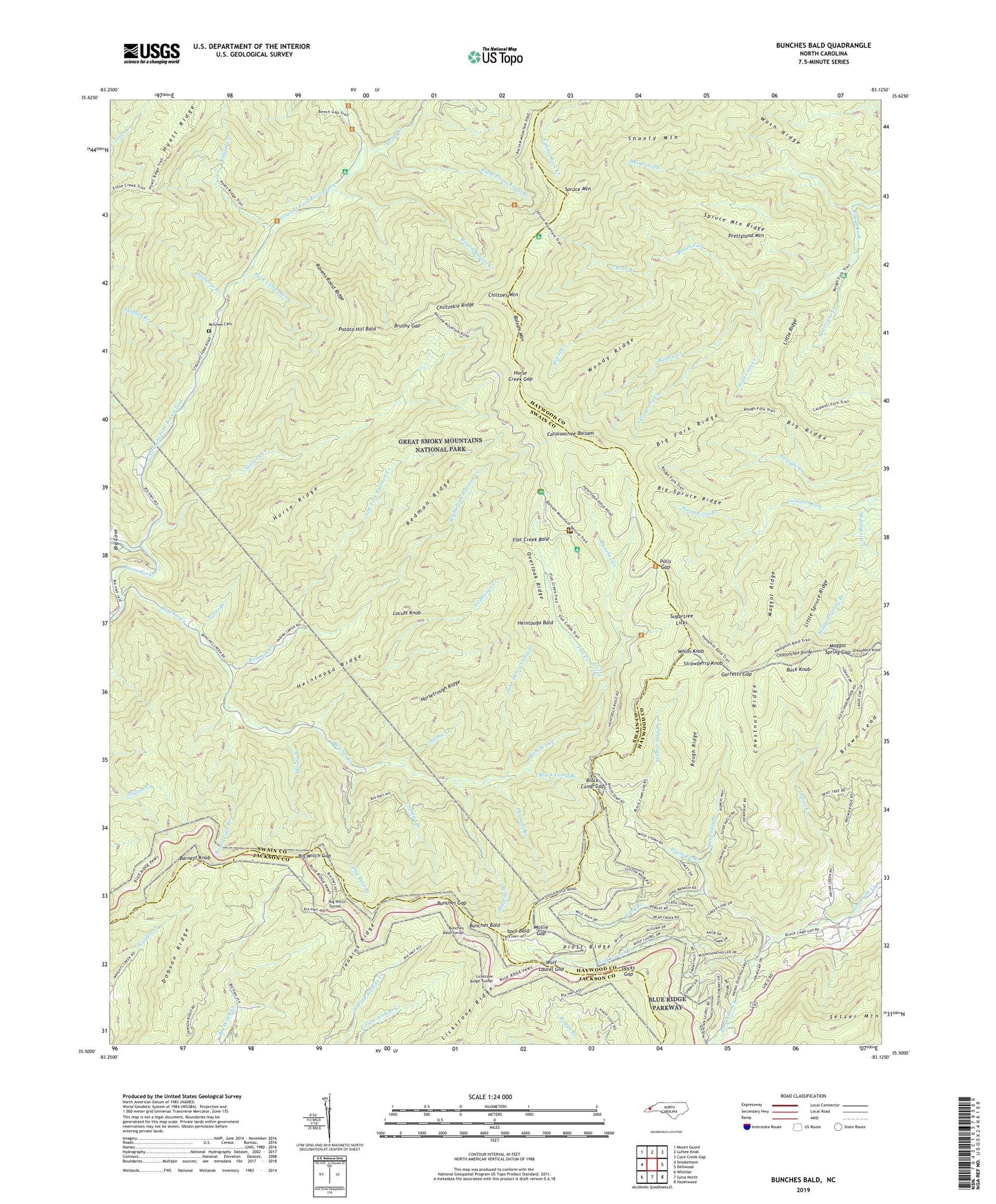
2019 topographic map quadrangle Bunches Bald in the state of North Carolina. Scale: 1:24000. Based on the newly updated USGS 7.5' US Topo map series, this map is in the following counties: Swain, Haywood, Jackson. The map contains contour data, water features, and other items you are used to seeing on USGS maps, but also has updated roads and other features. This is the next generation of topographic maps. Printed on high-quality waterproof paper with UV fade-resistant inks.
Quads adjacent to this one:
West: Smokemont
Northwest: Mount Guyot
North: Luftee Knob
Northeast: Cove Creek Gap
East: Dellwood
Southeast: Hazelwood
South: Sylva North
Southwest: Whittier
Contains the following named places: Balsam Mountain Campground, Barnett Knob, Bear Branch, Big Cove, Big Cove Mission, Big Fork Ridge, Big Ridge, Big Spruce Ridge, Big Witch Gap, Big Witch Overlook, Big Witch Tunnel, Black Camp Branch, Black Camp Gap, Board Cove Branch, Brown Lead, Brushy Gap, Buck Knob, Bunches Bald, Bunches Bald Overlook, Bunches Bald Tunnel, Bunches Creek, Bunches Gap, Cataloochee Balsam, Chestnut Ridge, Chiltoes Mountain, Chiltoskie Ridge, Deep Gap Branch, Dobson Ridge, Docks Gap, Flat Bald Branch, Flat Creek, Flat Creek Bald, Flat Creek Campsite, Flat Creek Falls, Garretts Gap, George Ira Creek, Heintooga Bald, Heintooga Creek, Heintooga Overlook, Heintooga Ridge, Horse Camp, Horse Creek, Horse Creek Gap, Horse Ridge, Horsetrough Ridge, Horsetrough Ridge Overlook, Hurricane Creek, Hyatt Creek, Indian Creek, Jenkins Ridge, Jenkins Ridge Overlook, John Henry Camp Creek, Jonathan Creek Overlook, Jones Creek, Ledge Creek, Left Fork Redman Creek, Lickstone Overlook, Lickstone Ridge, Lickstone Ridge Tunnel, Little Bald Branch, Little Ridge, Little Spruce Ridge, Locust Knob, Long Branch, Madcap Branch, Maggot Ridge, Maggot Spring Branch, Maggot Spring Gap, Mashie Stomp Creek, Masonic Monument, McGhee Cemetery, Messer Fork, Mile High Overlook, Mollie Gap, Moody Branch, Overlook Ridge, Peachtree Church, Pleasant Branch, Plott Balsam Overlook, Plott Ridge, Polls Gap, Potato Hill Bald, Prettyland Mountain, Quillaree Branch, Ravens Roost Ridge, Redman Creek, Redman Ridge, Right Fork Redman Creek, Right Prong Ledge Creek, Rock Camp Run, Rough Ridge, Round Bottom Campground, Round Bottom Creek, Round Bottom Horse Camp, Selma Creek, Shanty Mountain, Sheepback Knob, Skidder Branch, Soco Bald, Spread Branch, Spruce Mountain, Spruce Mountain Ridge, Stillwell Creek, Straight Fork Raven Fork, Strawberry Knob, Sugartree Licks, Thomas Divide Overlook, Tooni Branch, Warm Cove Branch, Wash Ridge, Whim Knob, Wolf Cove Creek, Wolf Laurel Branch, Wolf Laurel Gap, Woody Creek, Woody Ridge, Wycle Fork