MyTopo
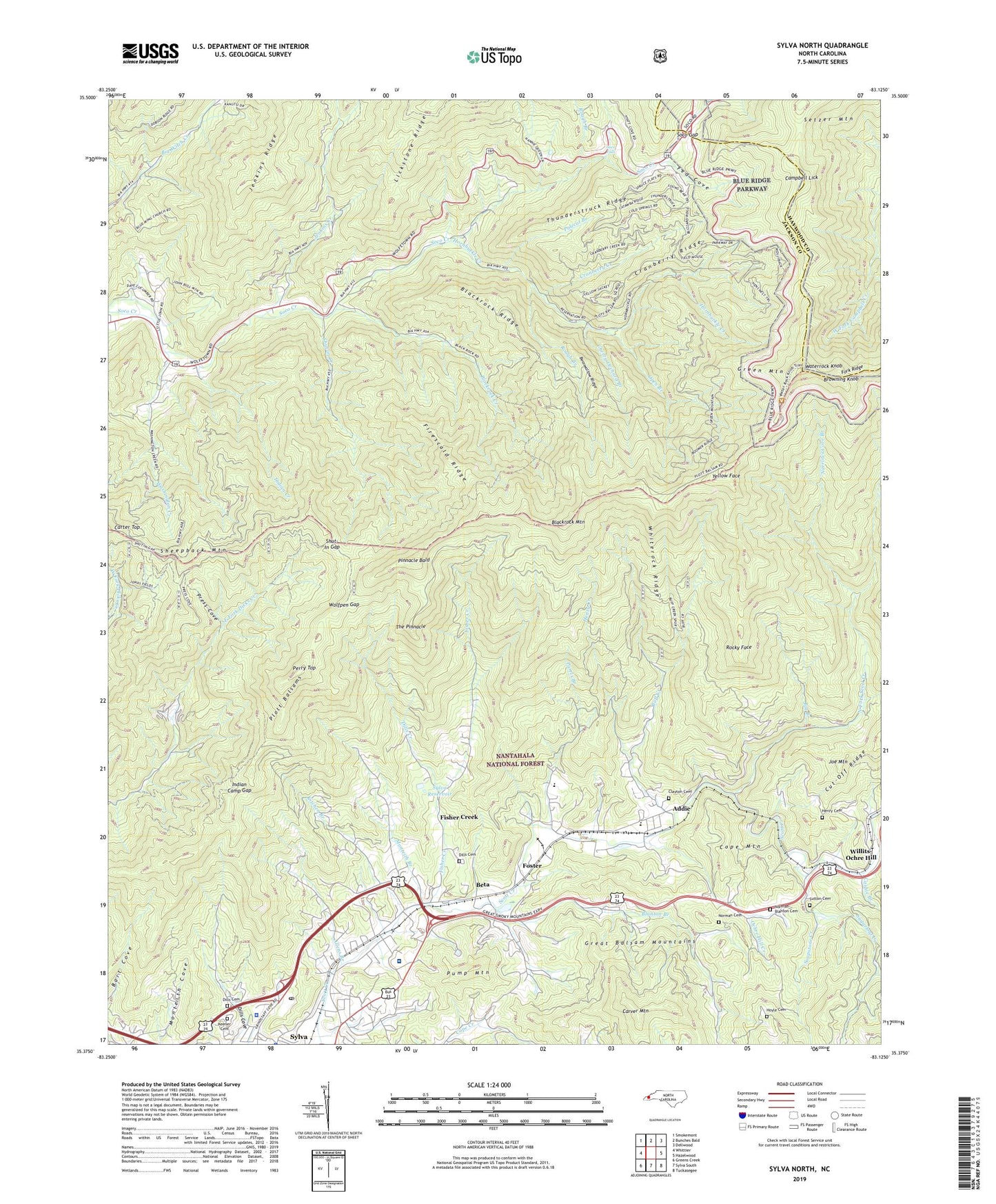
Sylva North North Carolina US Topo Map
Couldn't load pickup availability
Also explore the Sylva North Forest Service Topo of this same quad for updated USFS data
2022 topographic map quadrangle Sylva North in the state of North Carolina. Scale: 1:24000. Based on the newly updated USGS 7.5' US Topo map series, this map is in the following counties: Jackson, Haywood. The map contains contour data, water features, and other items you are used to seeing on USGS maps, but also has updated roads and other features. This is the next generation of topographic maps. Printed on high-quality waterproof paper with UV fade-resistant inks.
Quads adjacent to this one:
West: Whittier
Northwest: Smokemont
North: Bunches Bald
Northeast: Dellwood
East: Hazelwood
Southeast: Tuckasegee
South: Sylva South
Southwest: Greens Creek
This map covers the same area as the classic USGS quad with code o35083d2.
Contains the following named places: Addie, Allens Branch, Bearwallow Ridge, Beta, Big Branch, Blackrock Creek, Blackrock Mountain, Blackrock Ridge, Blanton Branch, Blue Wing Church, Browning Knob, Buff Creek, Buff Creek Church, Campbell Lick, Carver Mountain, Cashie Branch, Cherry Orchard Branch, Clayton Cemetery, Cope Mountain, Cranberry Creek, Cranberry Ridge, Cranberry Ridge Overlook, Dills Cemetery, Dills Cove, Dills Creek, East Fork Jenkins Creek, Fed Cove, Fed Cove Overlook, Firescald Ridge, Fisher Creek, Fork Ridge, Foster, Green Mountain, Hall, Harris Regional Hospital, Henry Cemetery, Henry Creek, Hornbuckle Creek, Hornbuckle Valley Overlook, Hoyle Cemetery, Indian Camp Gap, Indian Creek, Jackson County Sheriff's Office, Jackson Plaza, Jenkins Creek, Joe Mountain, Jonas Fields, Keener Cemetery, Kitchen Branch, Liberty Church, Lost Cove, Monteith Branch, Narrows Cove Branch, Norman - Blanton Cemetery, Norman Cemetery, North Fork Scott Creek, Ochre Hill Church, Ochre Hill Creek, Oldfield Church, Open Branch, Out-Off Ridge Overlook, Parris Branch, Perry Top, Pinnacle Bald, Plott Balsams, Polecat Branch, Press Cove, Pump Mountain, Rocky Face, Rough Branch, Scotts Creek Church, Scotts Creek School, Setzer Mountain, Sheepback Mountain, Shut-in Creek, Shut-In Gap, Soapstone Creek, Soco Falls, Soco Gap, Soco Gap Parking Area, Sugarloaf Creek, Sutton Cemetery, Sylva Post Office, Sylva Reservoir, The Pinnacle, Thunderstruck Ridge, Thunderstruck Ridge Overlook, Town of Sylva, Township of Sylva, Washington Creek, Waterrock Knob, Waterrock Knob Overlook, Wesleyan Church, West Fork Jenkins Creek, Whiterock Ridge, Willits-Ochre Hill, Wolfpen Gap, Wolftown Community, WRGC-AM (Sylva), Yellow Face, Yellow-Face Overlook