MyTopo
Cary North Carolina US Topo Map
Couldn't load pickup availability
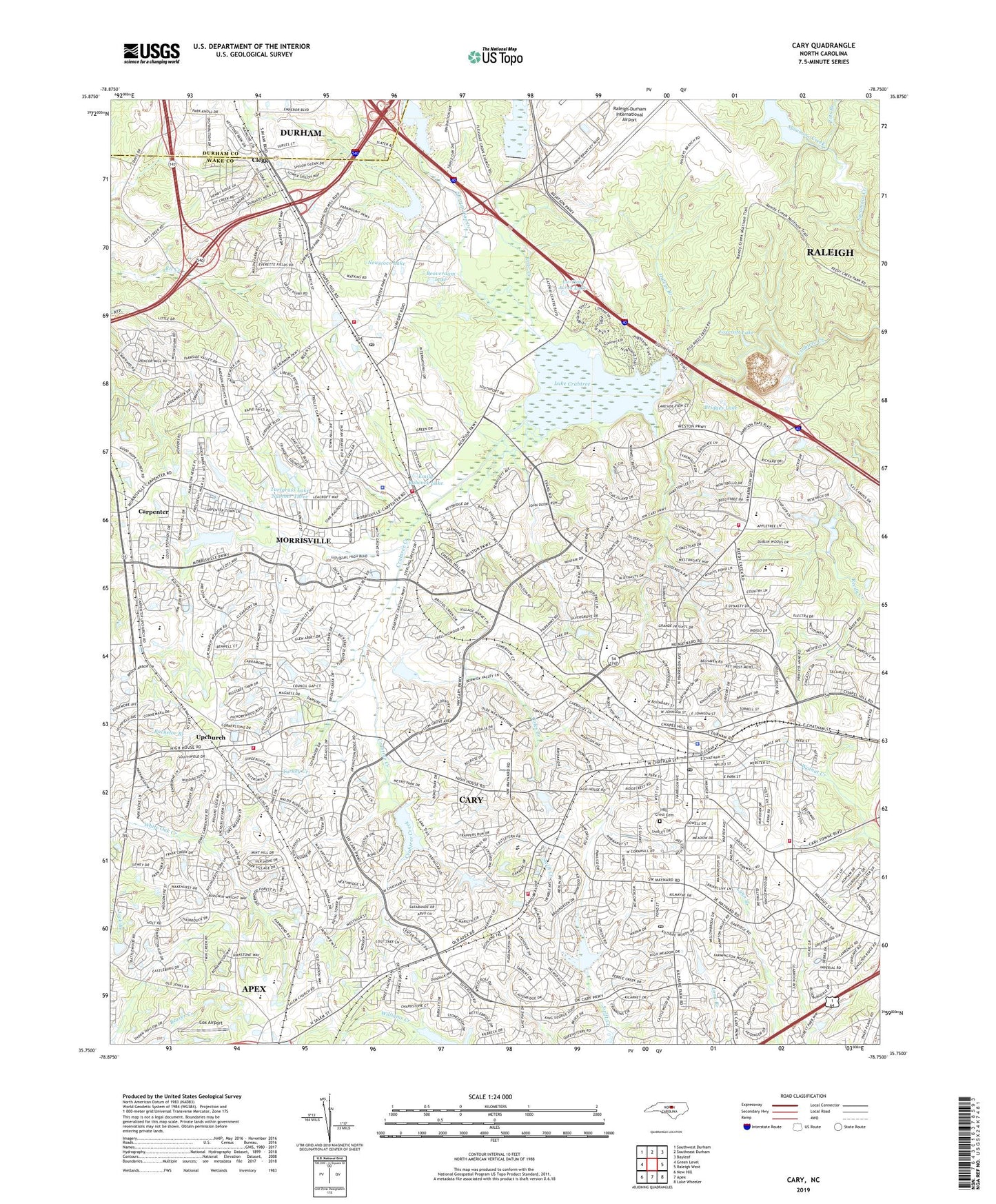
2022 topographic map quadrangle Cary in the state of North Carolina. Scale: 1:24000. Based on the newly updated USGS 7.5' US Topo map series, this map is in the following counties: Wake, Durham. The map contains contour data, water features, and other items you are used to seeing on USGS maps, but also has updated roads and other features. This is the next generation of topographic maps. Printed on high-quality waterproof paper with UV fade-resistant inks.
Quads adjacent to this one:
West: Green Level
Northwest: Southwest Durham
North: Southeast Durham
Northeast: Bayleaf
East: Raleigh West
Southeast: Lake Wheeler
South: Apex
Southwest: New Hill
This map covers the same area as the classic USGS quad with code o35078g7.
Contains the following named places: Academy Street Post Office, Adams Elementary School, Beaverdam Lake, Beechtree, Blackhawk, Briarcliff Elementary School, Bridges Lake, Brier Creek, Brier Creek Reservoir, Brookstone, Burtrose, Cambridge Forest, Carpenter, Cary, Cary Area Emergency Medical Services, Cary Church, Cary Elementary School, Cary Fire Department Station 1, Cary Fire Department Station 4, Cary Fire Department Station 5, Cary Fire Department Station 9, Cary High School, Cary Police Department Headquarters and District 1, Cary Post Office, Cary Towne Center Shopping Center, Cedar Creek, Cedar Forks Elementary School, Christs Sanctified Holy Church, Church of Faith II, Churchill Downs, Clegg, Coles Branch, Continental Can Company Lake Dam, Cox Airport, Crabtree Creek W/S Number Eighteen, Crabtree Creek W/S Number Eighteen Dam, Crabtree Creek W/S Structure Number Two Dam, Dublin Woods, Dutchess Village, East Cary Middle School, Edgehill Farms, Emily Babcock Lake, Farmington Woods, Farmington Woods Elementary School, Foxcroft Lake, Fred G Bond Metro Park, Goodhope Church, Greenwood Acres, Haleys Branch, Hatches Pond Dam, Hatchet Grove Church, Hazelwood, Hearthstone Farms, Highland Park, Hill Crest Cemetery, Hillsdale Forest, Hoffman Lake Dam, Holiday Acres Lake Dam, Homestead Estates, Irongate, Ivy Meadows, Kilarney Woods, Kildaire Farms, Kingswood School, Lake Crabtree, Lochaven, Lu-Tom Acres Lake, MacDonald Woods, Maynard Crossing Shopping Center, Maynard Pond, Medfield Estates, Morrisville, Morrisville Elementary School, Morrisville Fire and Rescue Department Station 1, Morrisville Fire and Rescue Department Station 2, Morrisville Police Department, Morrisville Post Office, Neuseoco Lake, Northwood School, Northwoods, Oxxford Hunt, Parkway, Pirates Cove, Plantation Estates, Pots Branch, Preston, Prime Outlets at Morrisville Shopping Center, Rainbow Estates, Raleigh-Durham Army Air Field, Reedy Creek Church, Russell Hills, Salem Church, Salem Middle School, Savon Height, Shiloh Church, Silverton, Sorrels Grove Church, Sree Venkateswara Temple of North Carolina, Stirrup Iron Creek, Stoneybrook, Town of Cary, Town of Morrisville, Township of Cary, Township of Cedar Fork, Trappers Run, Turfgrass Lake Number Three, Turkey Creek, Umstead Park Lake Lower Dam, Umstead Park Lake Upper Dam, Umstead Park Lower Lake, Upchurch, Wake County Emergency Medical Services Station 6, West Cary Middle School, Weston, Westpark Place, Willoughby Place, Wimbledon, Wishing Well, WKIX-AM (Raleigh), WPTF-AM (Raleigh), ZIP Codes: 27511, 27513, 27560