MyTopo
Bayleaf North Carolina US Topo Map
Couldn't load pickup availability
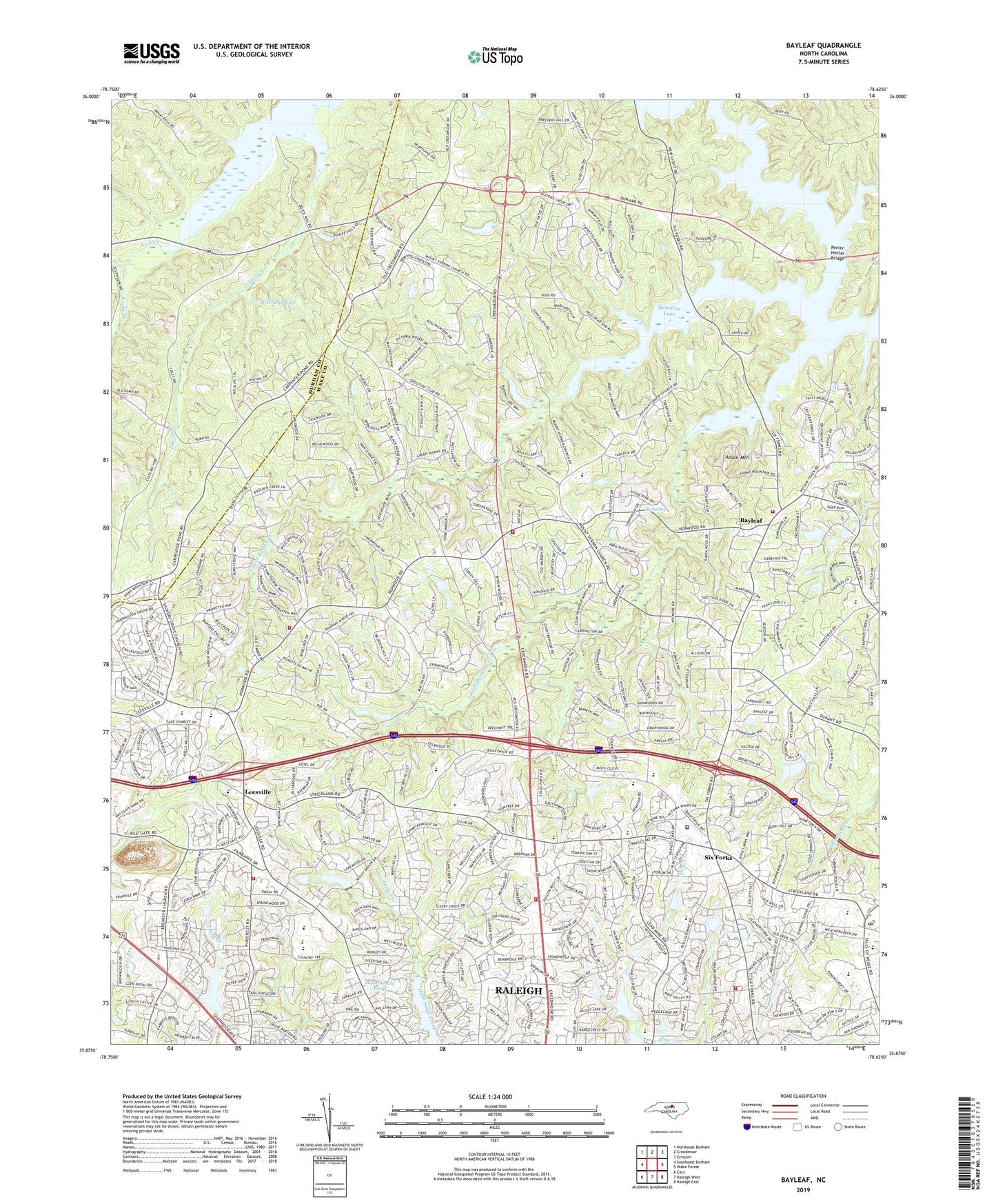
2022 topographic map quadrangle Bayleaf in the state of North Carolina. Scale: 1:24000. Based on the newly updated USGS 7.5' US Topo map series, this map is in the following counties: Wake, Durham. The map contains contour data, water features, and other items you are used to seeing on USGS maps, but also has updated roads and other features. This is the next generation of topographic maps. Printed on high-quality waterproof paper with UV fade-resistant inks.
Quads adjacent to this one:
West: Southeast Durham
Northwest: Northeast Durham
North: Creedmoor
Northeast: Grissom
East: Wake Forest
Southeast: Raleigh East
South: Raleigh West
Southwest: Cary
This map covers the same area as the classic USGS quad with code o35078h6.
Contains the following named places: Adam Mountain, Asbury United Methodist Church, Asbury United Methodist Church Preschool, Baileywick Road Elementary School, Baker Pond Dam, Baptist Grove Church, Bay Leaf Fire Department Station 1, Bay Leaf Fire Department Station 2, Bay Leaf School, Bayleaf, Bayleaf Church, Bethany Hills Baptist Church, Bethlehem Church, Brassfield Elementary School, Camp Adventure Lake Dam, Chestnut Grove Church, Christ Baptist Church, Church of the Nativity, Coachmans Trail Dam, Covenant Church International, Dunnaway Lake Dam, Durham Highway Fire Protection Association Station 1, Durham Highway Fire Protection Association Station 2, Edgewood Baptist Church, Falls of Neuse Road Church, Gethsemane Lutheran Church, Good Shepherd Lutheran Church, Good Shepherd Lutheran Preschool, Greystone Baptist Church, Hammonds Pond, Hickory Grove Church, Jewish Federation of Raleigh and Cary, Korean First Baptist Church, Laurel Creek, Leesville, Leesville Road Elementary School, Leesville Road High School, Leesville Road Middle School, Lower Barton Creek, Lower Springdale Estates Dam, Mitchell Pond, Mount Bethel Church, Mount Vernon Baptist Church, Mount Vernon Korean Mission, New Bethel Church, North Raleigh Church of the Nazarene, North Raleigh Community Church, North Raleigh Presbyterian Church, North Regional Library, North Ridge Bible Chapel, North Ridge Church, North Ridge Post Office, Penny-Hester Bridge, Pleasant Union Church, Poole Lake Dam, Poole Lake Number One Dam, Raleigh Christian Life Fellowship Church, Raleigh Fire Department Station 18, Raleigh Fire Department Station 23, Raleigh Fire Department Station 4, Redeemer Presbyterian Church, Regency Mall Shopping Center, Rocky Branch, Rogers Store, Saint Andrews Presbyterian Church, Saint Luke Evangelist Catholic Church, Saint Philip Lutheran Church, Saint Philip Lutheran Church Preschool, Shaw Lake Dam, Six Forks, Six Forks Baptist Church, Soapstone Church, Soapstone United Methodist Church, Stonebridge Dam, Tabernacle Baptist Church, Tabernacle Baptist Church Annex, Township of Bartons Creek, Township of Leesville, Union Grove Church, Upper Barton Creek, Upper Springdale Estates Dam, Victory Baptist Church, Wake Minster Church, West Millbrook Junior High School, Wildwood Country Club, ZIP Codes: 27613, 27615