MyTopo
Celo North Carolina US Topo Map
Couldn't load pickup availability
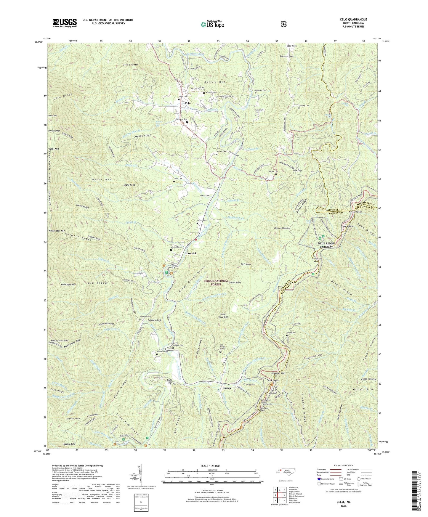
2019 topographic map quadrangle Celo in the state of North Carolina. Scale: 1:24000. Based on the newly updated USGS 7.5' US Topo map series, this map is in the following counties: Yancey, McDowell, Mitchell. The map contains contour data, water features, and other items you are used to seeing on USGS maps, but also has updated roads and other features. This is the next generation of topographic maps. Printed on high-quality waterproof paper with UV fade-resistant inks.
Quads adjacent to this one:
West: Mount Mitchell
Northwest: Burnsville
North: Micaville
Northeast: Spruce Pine
East: Little Switzerland
Southeast: Marion West
South: Old Fort
Southwest: Montreat
Contains the following named places: Autrey Cemetery, Bailey Mountain, Ballew Cemetery, Ballew Store, Bee Rock Creek, Big Ridge, Bill Autrey Branch, Black Mountain Campground, Bobs Creek, Bracher Cemetery, Bridle Ridge, Brown Creek, Buck Creek, Burgin Cove, Burnett Branch, Burnt Mountain, Busic Nork Center, Busick, Buzzard Rock, Carolina Hemlocks Recreation Area, Carroway Cemetery, Celo, Celo Knob, Celo Ridge, Clear Creek, Clear Creek Ridge, Colbert Creek, Colbert Creek Church, Colbert Ridge, Crabtree Falls, Crisawn Cemetery, Crisawn Knob, Dicks Gap, Dovers Branch, Dovers Ridge, East Branch Little Whiteoak Creek, East Fork Big Crabtree Creek, Estatoe Church, Fairview Cemetery, Fairview Church, Gibbs Cemetery, Gibbs Mountain, Glenn Church, Good Cemetery, Gragg Cemetery, Grindstaff Cemetery, Haines Eyebrow, Hall Chapel, Hamrick, Hannah Branch, Hazelnut Gap, Higgins Bald, Hoover Meadow, House Branch, John Autrey Branch, Laurel Branch, Lee Fields Cemetery, Left Prong Clear Creek, Left Prong Still Fork Creek, Little Celo Mountain, Little Mountain, Little Mountain Creek, Little Whiteoak Creek, Locust Creek, Locust Ridge, Long Arm Ridge, Long Branch, Lost Cove Picnic Area, Low Gap, Maple Bald Creek, Maple Camp Bald, Maple Camp Creek, Maple Camp Ridge, Middle Creek, Middle Fork Cow Creek, Middle Fork Rock Creek, Middle Prong Clear Creek, Middle Ridge, Middle Ridge Bald, Miller Chapel, Mount Mitchell Church, Murphy Branch, Murphy Falls, Nettie Patch, North Fork Cow Creek, North Fork Rock Creek, Open Ridge, Patton Cemetery, Percys Peak, Phipps Branch, Pine Ridge, Pine Ridge Branch, Pups Ridge, Rich Knob, Right Prong Clear Creek, Right Prong Still Fork Creek, Roaring Fork, Roaring Spout Branch, Roaring Spout Falls, Robinson Cemetery, Rock Creek, Sage Rock, Sevenmile Ridge, Shingle Pile Creek, Shuford Creek, Simmons Cemetery, Singecat Ridge, Snake Knob, South Estatoe Church, South Toe River School, South Toe Volunteer Fire and Rescue Station 1, Still Fork Creek, Stones Knob, Sugar Cove, Sugar Cove Gap, Thee Creek, Three Knobs, Timber Ridge, Township of South Toe, Twin Tunnel North, Twin Tunnel South, Twin Tunnels, Upper Falls, Victor Place Hunt Camp, Westall Cemetery, Whiteoak Creek, Whiteoak Creek Church, Winter Star Mountain, Woody Ridge