MyTopo
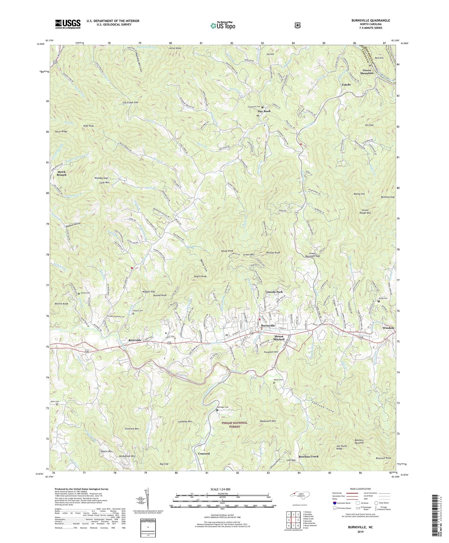
Burnsville North Carolina US Topo Map
Couldn't load pickup availability
Also explore the Burnsville Forest Service Topo of this same quad for updated USFS data
2022 topographic map quadrangle Burnsville in the state of North Carolina. Scale: 1:24000. Based on the newly updated USGS 7.5' US Topo map series, this map is in the following counties: Yancey, Mitchell. The map contains contour data, water features, and other items you are used to seeing on USGS maps, but also has updated roads and other features. This is the next generation of topographic maps. Printed on high-quality waterproof paper with UV fade-resistant inks.
Quads adjacent to this one:
West: Bald Creek
Northwest: Chestoa
North: Huntdale
Northeast: Bakersville
East: Micaville
Southeast: Celo
South: Mount Mitchell
Southwest: Barnardsville
This map covers the same area as the classic USGS quad with code o35082h3.
Contains the following named places: Allen Branch, Allen Cemetery, Anglin Branch, Anglin Knob, Austin Mountain, Bailey Branch, Bailey Cove, Bailey Hill, Baker Creek, Baker Creek School, Banks Cemetery, Banks Creek Church, Banks Creek School, Beebranch Mountain, Blevins Knob, Bloody Fork, Bluerock Knob, Bowlens Creek, Bowlens Creek Church, Bowlens Pyramid, Bowman Gap, Bowring Chapel, Buensville Hospital, Burnsville, Burnsville Elementary School, Burnsville Post Office, Burnsville Volunteer Fire Department, Byrds Branch, Cane Mountain, Cane River Church, Center Church, Clearmont Cemetery, Clearmont Church, Clearmont School, Clearmont Volunteer Fire Department Station 1, Clearmont Volunteer Fire Department Station 2, Concord, Cooper Gap, Cox Creek Gap, Day Book, Day Book Post Office, Dellinger Cemetery, Dix Gap, Dryspring Branch, East Yancey Middle School, Edney Branch, Edney Cemetery, English Branch, Ferguson Hill, George Fork, Green Mountain, Green Mountain Church, Green Mountain Gap, Green Mountain Post Office, Guilders Creek, Hampton Branch, Harris Memorial Church, Hawk Branch, High Peak, Horse Ridge, Jacks Creek Church, Joe Young Ridge, Johnson Cove, Lincoln Park, Locust Rough Mountain, Long Branch, Low Gap, McIntosh Branch, McWilliams Branch, Miller Chapel, Mine Fork, Mine Fork School, Mitchell Branch, Moses Branch, Mount Mitchell, Mount Mitchell Boys Camp, Mount Mitchell Post Office, Mountain Heritage High School, N W International Dam, North Carolina State Highway Patrol Troop G District 1, North Carolina State Prison Camp, Parson Branch, Patterson Branch, Peterson Branch, Phillips Knob, Phillips Knob Lookout, Phipps Creek, Pine Swamp Branch, Pounding Mill Cove, Ray Creek, Ray Gap, Ray Mine, Red Hill, Riverside, Rocky Knob, Rockyknob Mountain, Roland Branch, Roland Cemetery, Roland Hollow, Roland Knob, Roland School, Sampson Branch, South Cox Creek, Star Branch, Sugar Hollow, Sweetwater Branch, Tantrough Branch, Three Quarters Creek, Toecan Ranger District Office, Toecane School, Toledo, Town of Burnsville, Township of Burnsville, Township of Green Mountain, Township of Jacks Creek, Union Church, West Burnsville Church, Wilson Branch, Windom, WKYK-AM (Burnsville), Wolfpit Gap, Woodby Gap, Yancey County, Yancey County Sheriff's Office, Yancey Emergency Medical Services, Yancey Rescue Squad, Young Cemetery, Zion Church, ZIP Code: 28714